Feeds:
Posts
Comments

Posts Tagged ‘Buffalo’

Through my research, I have learned that street names often change over time.  Street name changes often come for a variety of reasons.   Some of Buffalo’s street names changed as early as 1825 after Joseph Ellicott left town. Other streets change as neighborhoods change.  For example, Lovejoy Street was named after a family of early Buffalo settlers during the War of 1812.   The neighborhood centered around Broadway and Fillmore was settled mostly by German and Polish immigrants.  When Central Terminal opened in 1929, it cut Lovejoy Street in two pieces.  The piece located in the polish neighborhood was named Paderewski Drive, after a Polish pianist and activist for Polish national freedom.

Over time, the neighborhood by the Central Terminal has changed again.  During the 40s and 50s, many of the German and Polish families moved away from the East Side of Buffalo towards suburbs, such as Cheektowaga.  Some of this move was financial – due to new Federal Programs making it easier for people to chase the “American Dream” of a house in the suburbs with a white picket fence.  Other reasons for leaving was the growing African-American presence in the city, which is referred to as “white flight”.   Perhaps now that the neighborhood has changed, we should think about changing the name of Paderewski Drive again?

clybourneRoad Less Traveled Productions will be putting on the play Clybourne Park from November 8th – December 1st.   Clybourne Park is a commentary  on the history of a house in an evolving neighborhood.   The play deals with segregation, white flight and cultural insecurities.

As part of promotion for the play, Road Less Traveled is encouraging Buffalonians to share their stories on neighborhoods they’ve lived in.   What was your neighborhood like?  Why did you move away?  Why did you stay?  You can visit the website and add your story to the map to help tell the story of Buffalo’s neighborhoods.  Click here to go to the website.  Many viewers of my blog have shared their wonderful stories with me; please share them on the website and let other people read about what life was like for you and your family in Buffalo.

The play is being performed at 710 Main Theatre (the old Studio Arena), from November 8th to December 1st.  You can buy tickets here.  Showtimes are Thursday, Friday and Saturday evenings and Sunday afternoons.   I encourage you to support Road Less Traveled’s tenth anniversary season and go see the play!   I also encourage you all to go to the Clybourne Park Buffalo website to share your stories, and talk with your friends and neighbors to share your stories.  Our stories are what make up our City.   While I focus mostly on this blog about telling the stories of people who may be long gone, those of us still here have stories to tell and our stories are important too!

We’ll be back to the regular streets posts with the next post!


Read Full Post »

porter
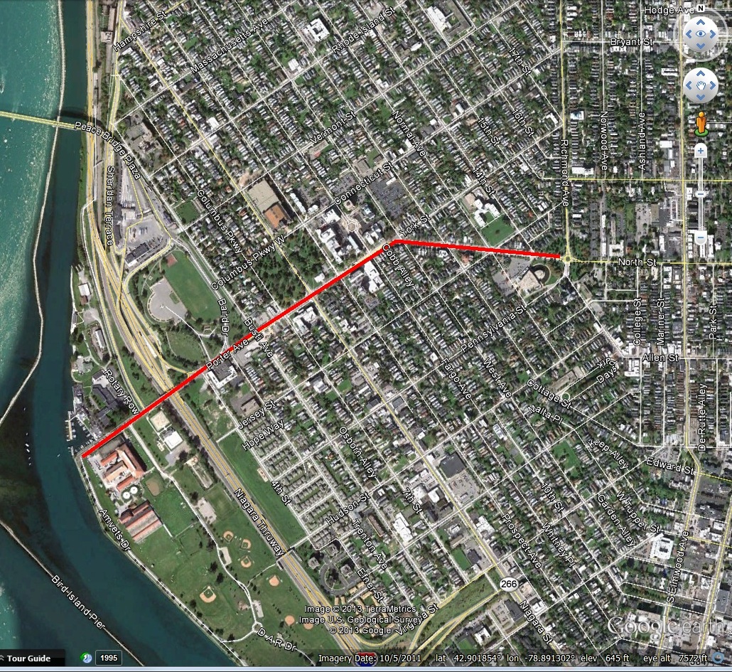
The Porter family was very influential in Buffalo/Niagara during its formation and early years of settlement.  There is Porter Ave in Buffalo, Porter Road in Niagara Falls, a Town of Porter in Niagara County and the Porter Quadrangle complex at University of Buffalo.   Porter Avenue is located in the Front Park neighborhood on the West Side of Buffalo and is an Olmsted Parkway.   The street was originally known as Guide Board Road and predates Joseph Ellicott’s time in Buffalo.  It was an Indian Trail used during the Revolutionary War to a ferry which led to Canada.

Guide Board Road sign, on North Street near Franklin Street

Guide Board Road sign, on North Street near Franklin Street

The original street alignment went straight west towards the Niagara River.  When Frederick Law Olmsted designed the City’s parkway system, he decided to turn a portion of York Street into Porter Avenue, in order to connect to Front Park and Fort Porter.  This allowed the connections between parks that completes our parks system.

Castle at Fort Porter Postcard

Castle at Fort Porter Postcard

The former Fort Porter was located on the Lake Erie shoreline just north of Front Park.  Olmsted included the Fort’s grounds into his original plans for Front Park.  The Fort was torn down to build the Peace Bridge.  The Porter Family included Augustus and Peter Porter.  Augustus was prominent in Niagara Falls, living on and owning Goat Island  His brother Peter Porter was prominent in Black Rock/Buffalo.  
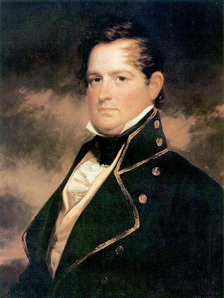
Peter Porter

Peter Porter

Peter Buell Porter was  born on August 14, 1773 and was raised in Connecticut.  He attended Yale and Litchfield Law School.  He moved west to Canandaigua for his law practice in 1793.  He served as Clerk of Ontario County from 1797 to 1804 and was elected to the New York State Assembly, representing Ontario and Steuben Counties in 1802.    

While in the Assembly, Peter Porter was influential in working with Joseph Ellicott to promote road construction in Buffalo.  However, shortly thereafter, Peter Porter began to develop a community two miles north of Buffalo called Black Rock.  At Black Rock, there was what was called a “safe and commodious” natural harbor, and the land was owned by New York State, unlike the majority of Western New York which was owned by the Holland Land Company.   Peter purchased land with his brother Augustus and Benjamin Baron to form Porter, Barton and Company.  New York State gave their trading firm a monopoly of the transportation business on the portage around Niagara Falls and it handled much of the trade on the Upper Great Lakes.

Around 1797, Joseph Ellicott tried to convince Porter and his friends to purchase property from the Holland Land Company.  Instead, they bought state lands along the Niagara River.  The laid out a town site, built warehouses and other trading facilities, establishing Black Rock.  This angered Paul Busti and other Holland Land Company agents, who then tried to purchased land from the State for the Holland Land Company in order to sabotage Porter’s plans.   As the town of Black Rock developed, the Holland Land Company tried hard to push Buffalo’s interests by using political influence in Albany.  However, Porter was equally determined to make Black Rock successful and had his own power in Albany.

Peter Porter moved to Black Rock in 1809 and was elected to the US House of Representatives, furthering his influence from Albany down to Washington, D.C.   He was so influential as a congressman that he convinced President Madison to move the customs house from Buffalo to the smaller Black Rock during summer (the more active) months. 

Map of Black Rock prior to the War of 1812

Map of Black Rock prior to the War of 1812

During the War of 1812, General Porter served in the New York State Militia.  In congress, Porter was labelled a War Hawk as he fought for security of the Niagara Frontier as the conflict leading up to the war became heated.  He found strong allies in Henry Clay and John Calhoun and was named  chair of the Foreign Affairs Committee.  Porter was presented a gold medal from Congress on November 3, 1814 for “gallantry and good conduct” during the Battle of Chippewa, Battle of Niagara and Battle of Erie.

Following the War of 1812, Porter was able to assist in getting the War Department to use federal troops to repair and improve roads between Fort Niagara and Black Rock which were damaged during the war.  Porter also brought federal funds to the area to build roads and canals.  Porter and his supporters also wanted the federal government to build roads from the “Buffalo Frontier” to Washington to foster trade between the federal capital, the Atlantic Coast and the Great Lakes.  This led to conflicts between Black Rock (which was Peter Porter, because of his vast real estate holdings and commercial enterprises) and Buffalo’s leaders – including Samuel Wilkeson, Albert Tracy, David Day and Oliver Forward.  Buffalo’s leaders were on the side of Dewitt Clinton, Mayor of New York City at the time.  Porter and his friends were on the anti-Clinton political faction.

General Peter served as Secretary of State of New York from 1815 to 1816.   During a special election after the resignation of Governor Tompkins, Tammany Hall printed ballots with Porter’s name on them.  Porter received 1300 votes, despite not running for office.  Governor Dewitt Clinton won that election, despite Tammany Hall’s efforts.

General Porter was appointed to the Canal Commission created to examine possible canal routes.  Governor Clinton opted for a Hudson River to Lake Erie straight across the state.  General Porter preferred two canals, one joining the Hudson River with Lake Ontario and one around Niagara Falls, joining Lake Erie and Ontario.  Buffalo Leaders and Joseph Ellicott preferred Clinton’s ideas, but in 1814, it seemed that the Canal Commission might adopt Porter’s suggestions.   By 1816, Porter had not been reappointed to the Canal Commission as he had accepted the office of boundary commissioner to clarify the disputed sections of the US-Canada Border.  Joseph Ellicott replaced Porter on the Commission, Dewitt Clinton had been elected Governor, and the Erie Canal took the alignment we are familiar with today.

The rivalry then shifted to whether Buffalo or Black Rock would be the western terminus for the Erie Canal.  Black Rock had a large, natural harbor which would be easy to expand and for years it had been the center of east-west trade and was used even by the merchants in Buffalo.  Black Rock also provided an escape from the turbulent winds and swells coming across Lake Erie.  It also would shorten the canal a few miles, lowering construction costs.  Buffalo had advantages too:  it was out of the range of British canons on the Canadian Shore (which was important given the recent War with Great Britain).  Higher water levels meant the canal would feed better in Buffalo.  Samuel Wilkeson led the charge, along with a group of enterprising men, determined to make Buffalo the canal terminus.  A report by engineers stated that the terminus should be located in Buffalo as the Black Rock harbor was too vulnerable to British attack, too exposed to ice damage and too expensive to develop.  While several later reports supported Black Rock, the Canal Commission designated Buffalo as the canal terminus in 1822, on the advice of four out of five of its engineers.  Efforts by Porter and his friends to alter the decision were fruitless, and bills were passed in the legislature for a canal link from Tonawanda to Buffalo, completely bypassing Black Rock.

Porter House facing Niagara Street circa 1880s when Lewis Allen owned the house

General Porter built a house at 1192 Niagara Street (between Breckenridge and Ferry) in 1816.  He Porter married Letitia Breckenridge of the prominent Breckenridge family.   Breckenridge Street, which was originally called Commerce Street, is named after her.     When Grover Cleveland moved here to Buffalo, he lived in the Porter house, with his Aunt and Uncle, the Allens.   Peter and Letitia’s son Peter A. Porter went on to become a Civil War Colonel, killed in the Battle of Cold Harbor in 1864.  

General Porter donated the land for the Union Meeting House Church across the street from his house.  The church is located at 44 Breckenridge and is also known as the Breckenridge Street Church.  

Peter Porter was also President of Jubilee Water Works, the first company to bring water into people’s homes.  The water came from the jubilee spring (located in present day Forest Lawn…Crystal Lake is formed from waters from the spring) and was pumped through wooden pipes.  Some of Buffalo’s wooden water pipes still exist.

porter grave

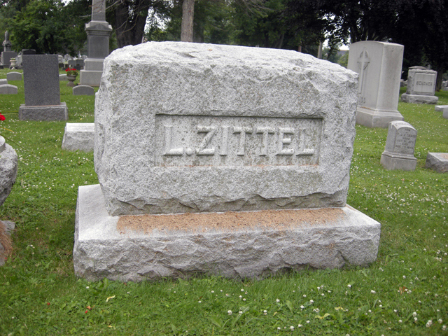
Peter Porter’s Grave

In 1837, Black Rock was dealt another blow when General Porter sold his interests there and moved to Niagara Falls where he built a new home.  Peter Porter died in 1844, and Fort Porter was named in honor of the businessman-politician-soldier.  Peter and Augustus Porter are both buried in Oakwood Cemetery in Niagara Falls.  Nine years after his death, Porter’s beloved Black Rock was annexed to a thriving, expanding Buffalo.   Black Rock became a neighborhood in the City of Buffalo.

The next time you’re driving down the 190 along the Niagara River or driving through Black Rock, think about Peter Porter and what our region might look like if we lived in the City of Black Rock and the Erie Canal went from Lake Erie to Lake Ontario!

Learn about other streets by checking out the street index.


Sources:

  1. Courier Express, July 24 1938, sec 6, p.4.
  2. Grande, Joseph.  Peter B. Porter and the Buffalo Black-Rock Rivalry.  Buffalo and Erie County Historical Society Publications.

Read Full Post »

langLang Avenue is located between Bailey Avenue and East End Avenue, between Genesee Street and Delavan Avenue, in the Schiller Park neighborhood of the East Side of Buffalo.  Portions of the street are paved in brick.

Lang Avenue is named after Gerhard Lang, owner of one of Buffalo’s premiere and largest breweries at the turn of the 19th Century, the Gerhard Lang Brewery.

langportraitGerhard Lang was born in Germany in 1835.  He came to Buffalo in 1848 at the age of 14 with his father, Jacob Lang.  Jacob Lang was a butcher and Gerhard learned English while working in the butcher shop.   Around 1862, he assumed control of the Born brewery at the corner of Genesee and Jefferson streets.   Mr. Lang married Born’s daughter and assumed control of the brewery after a few years of marriage.

In 1875, he purchased the a site at Jefferson and Best Streets to expand his facilities.   He toured other breweries across the country to determine the best design for his facility. The Gerhard Lang Brewery was located on the entire block bounded by Jefferson, Best, Berlin and Dodge Streets was the largest brewery in the State outside of New York City.   Berlin Street was renamed Pershing after WWI (in 1920).

breweryThe Lang Brewery was called “the Palace Brewery”, because it was built with a typical Victorian opulence.   Once the new brewery was built, Mr. Lang used the old brewery at Jefferson and Genesee Street for bottling works and malting house.    The annual capacity of the Gerhard Lang Brewery was over 300,000 barrels.  Lang’s beer was known all over the country for its excellence in quality, purity and wholesomeness.

By 1887, the brewery employed 110 men and distributed to Virginia, Boston, Baltimore, Washington, Philadelphia and New York City.

In addition to the brewery, Mr. Lang served as Alderman of the Sixth Ward and was a Trustee in the Western Savings Bank.  Mr. Lang was a member at St. Louis Roman Catholic Church and donated one of the stain glass windows to the church.

lang graveGerhard Lang died in 1892 and is buried in the United German and French Cemetery in Cheektowaga.  After his death, Edwin G.S. Miller took over the brewery, along with Jacob Lang, Gerhard’s son.

Before Prohibition, the Lang Brewery also owned many saloons that sold its brews.  It is said that Lang’s owned more saloons and beer gardens than anyone in Buffalo, as many as 80 at one point.

Before the automobile, horses were used to transport beer around town.  The brewery kept 500 horses in a stable in Fort Erie to distribute Lang’s beer.

During Prohibition, Lang’s produced dairy and soda products.  There was Lang’s Dairy & Creamery, Lang’s Bakery and products like “Hyan-Dry” brand soda and “Liberty Brew”, a malt extract beverage.  After Prohibition, Lang’s was one of the first to start back up.  However, the market had changed, and the new regulations and taxes made it difficult for local breweries to stay competitive.

The Gerhard Lang Brewery shut down in January of 1949 after 109 years in business.

Langs-Brewery-Match-Safes-Gerhard-Lang-Brewery_62722-2

Gerhardt Street, located on a portion of where the Brewery was located was likely also named after Gerhard Lang, although I was not able to find any specifics linking this together.

To learn about other streets, check out the Street Index.

Sources:

  1. A History of the City of Buffalo:  Its Men and Institutions.  Published by the Buffalo Evening News:  Buffalo, 1908.
  2. History of the City of Buffalo and Erie County:  With Illustrations and Biographical Sketches of some of its Prominent Men and Pioneers.  Edited by H. Perry Smith, D. Mason & Co Publishers, Syracuse NY 1884.

Read Full Post »

Hopkins Street in South Buffalo

Hopkins Street in South Buffalo

Hopkins Street is a north-south thoroughfare in South Buffalo.  The road leads from South Park north towards the Buffalo River.  Historically this area was a mix of commercial and industrial uses, connecting the steel mills to the adjacent South Buffalo neighborhoods.

Hopkins Street is named for Brigadier General Timothy S. Hopkins, a War of 1812 general.    Hopkins Road in Amherst is also named General Hopkins.

The Hopkins family descended from Stephen Hopkins, who came over on the Mayflower.  Oceanus Hopkins was born aboard the Mayflower.  Most history books list Oceanus as a son; however, Hopkins family lore indicates that the family was bad at latin, she was a girl and should have been thus named Oceana.  A second Stephen Hopkins signed the Declaration of Independence and Ichabod Hopkins signed the Constitution in Philadelphia on behalf of Massachusetts    Ichabod Hopkins had a son, Timothy Soveral Hopkins.

Timothy S. Hopkins

Timothy S. Hopkins

Timothy S. Hopkins was born in Massachusetts in 1776.  He arrived in Clarence at the age of 22, arriving by foot.  He then purchased land in 1804 from the Holland Land Company.  Mr. Hopkins is said to have grown the first wheat on the Holland Purchase, on a farm in Clarence Hollow.   When it was ready to be ground, he had to travel to Street’s mill at Chippewa, a village that became a part of the City of Niagara Falls, Ontario.  This was a distance of 40 miles!  The trip took four days and included a ferry ride from Black Rock, where only one family resided – the family of the ferry owner!  Timothy married his wife Nancy Kerr in Williamsville; their marriage was the first recorded marriage in Erie County.  They settled on Main Street on a farm in Snyder, near where Amherst Central High School is currently located.

Burning of Black Rock, December 1813

Burning of Black Rock, December 1813

During the War of 1812, Mr. Hopkins rose through the rank to Brigadier General.   He was an important part of the Battle Of Buffalo (also known as Battle of Black Rock), where he was stationed in Black Rock.  Following the war, he resigned from his post.

In 1819, he became the first Supervisor of the Town of Amherst and later served as Justice of the Peace.  His reputation spread through the area, and he was elected Sheriff of Erie County.  He was later elected to the New York State Assembly.

The Cayuga Street Stone School

The Cayuga Street Stone School

The Cayuga Street stone school-house in Williamsville was built by Timothy S. Hopkins in 1840 and still stands in Williamsville at 72 Cayuga.  He died January 23, 1853.

Nelson Hopkins grave

Nelson Hopkins grave

Nelson Kerr Hopkins, Timothy’s son, owned much of the land which included Hopkins Street.  Nelson subdivided the land into building lots and named the street after his father.  Nelson served as President of the Common Council of Buffalo and was New York State Comptroller from 1872 to 1875.  Nelson also organized the City’s first paid fire department and served as fire commissioner for ten years.  Nelson died in 1904 and is buried in Forest Lawn.

Timothy A. Hopkins

Timothy A. Hopkins

Nelson’s brother, Timothy Augustus Hopkins owned the Eagle Hotel in Williamsville, which is now known as the Eagle House.   He also operated a mill near the Eagle House, served as Justice of the Peace and Erie County Sheriff.  Timothy A. Hopkins is responsible for building a bridge over the Erie Canal in the Tonawanda Creek area, and constructing drainage ditches in the northern part of Amherst to reclaim thousands of acres of land that were often covered by spring floods after a dam was placed near the mouth of Tonawanda Creek for canal purpose.  Timothy A. Hopkins passed away in 1894 and is buried in Williamsville Cemetery.

The Hopkins Street area is currently a part of the City of Buffalo South Buffalo Brownfield Opportunity Area (BOA).  This study being done by New York State is working to revitalize the neighborhood by cleaning up vacant industrial sites and marketing properties for redevelopment.  More information about the South Buffalo BOA can be found through Buffalo Urban Development Corporation.

Be sure to check out the Street Index to learn about other streets!

Sources:

  1. “Hopkins Street named for 1812 General” Courier Express.  Oct 30 1939, sec 6 p 4.
  2. Larned, Josephus Nelson.  The Progress of the Empire State:  the History of Buffalo.  Published by The Progress of the Empire State Company, New York:  1913.
  3. Smith, Henry Perry.  History of the City of Buffalo and Erie County, Volume 1:  1620-1884.   D. Mason & Co Publishers, Syracuse NY: 1884.

Read Full Post »

Hertel Avenue is a major east-west thoroughfare in North Buffalo running from Main Street to the Niagara River. The street was previously known as Cornelius Creek Road, named after the creek, which ran near the street. Hertel Avenue was named for John Stephen Hertel, former County Supervisor.

Hertel Avenue and others Named After Black Rock Land Company Associates

Hertel Avenue and other streets named after Black Rock Land Company associates

Mr. Hertel was one of three owners of the land that is now Riverside Park and was a founder of the Black Rock Land Company, the first land development company in Buffalo. The Black Rock Land Company was founded in 1888 and consisted of John Hertel, John Esser, Frank Argus, Louis Roesch and Frederick Ullman. You’ll notice that several other streets in the Black Rock/Riverside neighborhoods are named after these men.

John Stephen Hertel came to Black Rock with his parents at the age of two, immigrating from Edesheim Germany. Mr. Hertel attended St. Francis School and learned the cooper trade, making barrels for brewers and distillers. He then became involved in the hotel business. He opened a hotel at the corner of what would become Hertel Avenue and Niagara Street. Before the 1890s, the Riverside area was primarily rural countryside. At the time, the street that would become Hertel Avenue only extended from Niagara Street to Military Road. When the Niagara Horse Car Line was extended to Hertel Avenue, the legend says that Mr. Hertel was so excited, he ran out of the hotel without a coat to be the first to ride on the first horse-car to pass the hotel.

John S. Hertel, 1899

John S. Hertel, 1899

Mr. Hertel was also the director of the Erie Fire Insurance Company and had extensive real estate holdings. The Black Rock Land Company was formed in 1888 and was one of the first development companyies in the City of Buffalo. The Land Company included Mr. Hertel, Mr. Esser, Mr. Argus, Mr. Roesch and Mr. Ullman. Mr. Hertel’s property included most of the land occupied by Peoria Street and Hartman Place. He subdivided the streets and named the latter for the family of his wife, the former Anna S. Hartman of Rochester. The hotel was successful for Mr. Hertel. He then went into business with John J. Esser and Frank Argus to purchase what was known as Germania Park, which at the time was a private picnic grounds with a boat launch. They built a hotel at Germania Park. The City of Buffalo offered to purchase their property.  The City of Buffalo used this site to create Riverside Park.

Rvierside Park, about 1910

Riverside Park, about 1910

At the time, there was great support for the City to buy Germania Park, to give the public a place to enjoy the river “where any resident of Buffalo could go with his whole family and be free from beer saloons and drunken men”. Riverside Park was the final park designed for Buffalo by the Olmsted Architecture Firm, following Frederick Law Olmsted’s retirement. The park was designed in 1898, at the time the Erie Canal traversed the park, separating the shoreline from the main part of the park. The original 22-acre park included a boat dock and canal overpass. The New York State Thruway I-190 currently runs along the Erie Canal alignment. The park was expanded in 1912 to include an additional 17 acres on the south side of the park. The original southern boundary was a line extending from Esser Avenue to the Niagara River.

After selling Germania Park, Mr. Hertel and Mr. Esser left the hotel business. They entered into the coal and wood business, establishing the business near the corner of Niagara and Farmer Streets. They also established the Tonawanda Street Planing Mill at Tonawanda and Arthur Streets.

John Hertel and his wife Anna lived with their family at 362 Dearborn Street. The Hertel family lived in the house for several generations, his son John Stephen Hertel II, his daughter Mrs. Franscis Healy and his grandson John Hertel Healy all lived in the Dearborn house.

hertel grave

John Stephen Hertel was a life long democrat and was active in local politics. He was unsuccessful in a campaign for congress. For 27 years, he was a lieutenant colonel of the Knights of St. John. He was a member of St. Mary’s Commandery and an organizer of the commendary at St. Francis Church.  St. Francis Church is now the Buffalo Religious Arts Center. He was active in the Knights of Columbus, the Catholic Men’s Benevolent Association, the Foresters of America and the Black Rock Businessmen’s Association. He died in 1917 and is buried at the United German and French Cemetery in Cheektowaga

To learn about other streets, check out the Street Index.

Sources:

Read Full Post »

zittelLouis Zittel was born in Johnsonsburg, Wyoming County, New York in February 1836.   His parents, Anna and Peter, came to the States from Germany shortly before Louis was born.  Mr. Zittel was educated in the public schools.  As a young man in the 1860s, Mr. Zittel moved to Buffalo and purchased a farm at the corner of Seneca and Cazenovia Streets.  At the time, the area we know of as South Buffalo only consisted of four streets – Buffum, Seneca, Cazenovia and Indian Church.  You could take a stagecoach to South Buffalo from Buffalo, and the trip was so long, it was generally only worth it if you were going to spend the night.  Mr. Zittel established a post office in South Buffalo.  Before 1891, the Post Office Department had no established policies regarding post office naming.  Postmasters were allowed to name their post offices as they wished.  Mr. Zittel named his post office “South Buffalo”, thereby creating the hamlet of South Buffalo and forever banishing “south side” from our city’s geography.

In 1887, Frederick Law Olmsted was commissioned to design a new park for the southern portion of the City (at this point, he had already designed what we know as Delaware, Front and Martin Luther King Parks).  Olmsted’s original vision for the South Buffalo park consisted of a large waterfront park along the Lake Erie shore south of what is now Tifft Street, east to the railroad corridor.  The original design was rejected as it was too costly, too likely to be damaged by storms coming off the lake and too far away from the residential areas of South Buffalo.  In 1888, Park Commissioners began looking for another site suitable for park use.  Three sites were identified to be used – the 76-acre Hart Farm which was being promoted for residential development along Cazenovia Creek, the grove at Mineral Springs, and a 156-acre just outside the southern boundary of the City limits.  The Parks Commissioners ended up approving two parks, that we now know as South Park and Cazenovia Park.

Olmsted's Cazenovia Park Plan

Olmsted’s Cazenovia Park Plan

Louis Zittel was a strong proponent for creating the park at the Cazenovia Creek site.  Serving as a Park Commissioner, Mr. Zittel worked hard to get the unused Hart Farm tract used as a park.  The park is a monument to Mr. Zittel’s perseverance and interest in benefiting his section of the City.  After the park was laid out, he moved to 150 Cazenovia Street, where he could view the park from his front windows.  The property where his house stood is now the American Legion.

After his move, he subdivided his farmland and developed the streets surrounding the street that bears his name.

Mr. Zittel died on April 22, 1921 at his home on Cazenovia Street at the age of 87 years.  He is buried in Forest Lawn.

grave

To read about other streets, check out the Street Index.

Sources:

  1. “Proceedings of the Society”, Volume 26. Edited by Frank H. Severance.  Buffalo Historical Society Publications, 1922.
  2. “Named after Park Commissioner”.  Courier Express, March 12 1939, sec 5, p 12.

Read Full Post »

winspearWinspear Avenue and Northrup Place are located in the University Heights neighborhood of North Buffalo.    Winspear Avenue runs between the former Erie Railroad corridor across Main Street to Bailey Avenue.  Northrup place runs parallel to W. Winspear, meeting up with Winspear just across Main Street.

The streets were named after business partners who developed the streets in the vicinity of  the streets that were named after them and what is now the University of Buffalo – Charles Winspear and Eli Northrup.  Charles and Eli both grew up in Elma, New York, sons of two of the first settlers in Elma.

Three members of the Winspear family have held important public positions.  William Winspear settled in Elma prior to the Civil War and served on the Erie County Board of Supervisors.   William owned a mill on the south side of Big Buffalo Creek.  Winspear Road in Elma is named after William Winspear.  Captain Robert Winspear, William’s nephew served on the Buffalo police department for more than 30 years.

Charles W. Winspear

Charles W. Winspear

William’s son and Robert’s cousin, Charles, was born in 1854 in Elma and began his education in the rural schools.  Charles came to Buffalo as a young man.   At the age of 23, he was appointed clerk of the Erie County Almshouse and Insane Asylum, which later became what are now Crosby and Hayes Halls on the University of Buffalo South Campus.

The original Almshouse had been built around 1850.  The first Almshouse burned in 1854 and its replacement burned in 1862.  The almshouse was located where Crosby Hall is today.  The Insane Asylum building was constructed in 11874 to replace the outdated structure and is now Hayes Hall.  By 1900, the Insane Asylum had become the County Hospital.  Hayes Annex D and Wende Hall were also a part of the County Hospital Complex and have been around since at least 1900.

Winspear Avenue was laid out around 1880.  Around this time, development of the neighborhood was attempted by Alexander Ross. This attempt failed because transportation to this northern corner of the City of Buffalo was difficult.  The street car only went to Cold Spring (around Ferry Street and Main Street).  The City boundary did not include the area that became University Heights at this time.  Buffalo’s growing population and improved transportation spurred successful development further away from the downtown core.  The Buffalo and Williamsville Electric Railway trolley opened in 1893 and ran along Main Street.  In 1898, the City boundary had expanded to include this area.

Erie County Almshouse and Insane Asylum (source:  http://www.poorhousestory.com/ERIE.htm)

Erie County Almshouse and Insane Asylum
(source: http://www.poorhousestory.com/ERIE.htm)

In 1893, Charles became superintendent of the New York State Custodial Asylum for Feeble-minded Women in Newark, New York (in Wayne County_.  Although he lived in Newark until his death in 1916, he retained many connections in Buffalo.  Charles Winspear is buried in Newark Cemetery in Newark, NY.

Eli B. Northrup

Eli B. Northrup

While working in Newark Institution in 1909, Charles formed a partnership with Eli Northrup in the real estate business.  They bought large tract of land south of Englewood Avenue and developed several streets, including Winspear Avenue and Northrup Place.   West Northrup Place was originally called Morton Street, Northrup Place was originally Hillary Place and Winspear was known as Wilmer Avenue.

It is likely that Charles and Eli sensed that there was potential for growth as the University of Buffalo purchased the almshouse and farm from the County following its closure in 1909.  This was a unique location because you were close to the streetcar to take you into Downtown Buffalo via Main Street and also close to the Train Station to take you to Niagara Falls (it was located at Main Street and LaSalle Avenue).

Eli Baker Northrup was born in January 1836 in Holland, NY and raised in Elma.  His father, Lewis Northrup, had built the first house in the Spring Brook hamlet of Elma in 1843.  Northrup Road in Elma is named after Lewis.  Lewis Northrup built a saw mill on Cazenovia Creek in 1844 and a grist mill ten years later.  Eli Northrup inherited the saw mill and grist mill in 1866.  Eli remodeled the mills and built a stone dam in 1873.    Eli died in January 1912. and is buried in Union Cemetery in Elma, New York.

Learn about other streets by checking out the Street Index.

Sources:

  1. Winspear Avenue Memorial to State Charities Agent – Courier Express, Jan 29, 1939, Buffalo Streets Vol 2, pg. 167
  2. “University at Buffalo – Draft GEIS:  University at Buffalo Comprehensive Physical Plan”, SUNY at Buffalo, October 2011
  3. Jackman, Warren.  History of the Town of Elma, Erie County, 1620-1900.   Printed by G.M. Hasauer & Son, 1902.

Read Full Post »

Dodge Street

Dodge Street

Dodge Street is a street in the Cold Springs neighborhood on  the East Side of Buffalo.  The street runs for about a mile, from Main Street to Humboldt Parkway and is named for Alvan Leonard Dodge.

Alvan’s father, Alvan Senior was considered courageous when he built a log cabin on Main Street, north of Summer Street in 1811.   At the time, this was well outside the Village limits and well into the primeval forests.  The area was at high risk for attacks from the Native Americans.  However, the Dodge family lucked out when the village was burned in 1813, as their house was well outside the village, and therefore, left standing.  They were one of the few families to be able to return to their home following the fire.  Alvan Senior served as Magistrate of the County of Niagara (at the time, Niagara County included what is now Erie County) and held other official positions in the towns of Black Rock and Buffalo.  Alvan Senior died in 1846 and is buried at Forest Lawn.

Alvan Leonard Dodge witnessed Buffalo’s development from a tiny frontier village into one of the most important cities in the country.  By the end of his life, the Dodge family farm was close to being in the middle of the City that had grown up during Alvan’s lifetime.  Alvan, Junior was born on March 21, 1808 in Lowville, NY and came with his family to settle in Buffalo in 1811.

Ferry Street Schoolhouse source

Ferry Street Schoolhouse
source

He was educated in the school in a schoolhouse on Ferry Street that was known as Buffalo District School #2 at the time.  One term, his teacher was Millard Fillmore, who taught while he was also reading law and serving as postmaster.  At the time, the actual Cold Springs still flowed through the neighborhood.    The waters from this spring became the Jubilee Water Works, one of Buffalo’s first water systems.  The springs feed into the lake in Forest Lawn Cemetery.

As a young man, Alvan, Junior acquired a farm of several hundred acres, bounded by Main, East Ferry, Best and Jefferson.  Mr. Dodge built a house at the corner of Main and Dodge Streets, using lumber cleared from his property to build the house.

He sold part of his land to the City of Buffalo in 1880.   After selling the land to the City, he subdivided the remainder of his property for development and laid out streets on his land.  The area became the place for many prominent German families to live.   Legend has it that there was one field that grew the best corn around, so Mr. Dodge refused to convert it to a building lot.

The City used the property they had purchased to build a reservoir.  At the time, the City relied on reservoirs for water service.  This reservoir was known as Prospect Reservoir, since it replaced the reservoir of the same name which was located on Prospect Hill.  When the Colonel Ward Pumping Station opened in 1915, it rendered most of the reservoirs obsolete.

1988 WAR MEMORIAL STADIUM BUFFALO COLOR edited The reservoir sat unused until the 1930s.  Between 1936 and 1938, Buffalo Civic Stadium was built as a WPA project.  It was originally going to be named Roesch Memorial and then Grover Cleveland Stadium before Buffalo Civic Stadium became its official name.  The stadium was nicknamed “The Rockpile” since it seemed to rise out of the quarried land that had been the reservoir.  The stadium became home of the Buffalo Bills football team in 1946.  The stadium was renamed War Memorial Stadium in 1960.  The Buffalo Bisons baseball team used the stadium after Offerman Stadium at Michigan and East Ferry was demolished.  The Bills left the stadium in 1972 when Rich Stadium was built.  The Bisons left the stadium when Pilot Field opened in 1988.

Once the stadium was empty, many of the nearby residents wanted the stadium demolished.  The stadium hadn’t been maintained well during its final years and was in poor condition..   The Dodge-Jefferson and the Best-Jefferson entrances are all that remain today of War Memorial Stadium, which has been converted into the Johnnie B. Wiley Sports Pavilion.   Johnnie B. Willey was a city resident who worked to help young people of the East Side.

Dodge Mill in Williamsville source:  http://www.edyoungs.com/images/dodgemillfront.jpg

Dodge Mill in Williamsville
source

Alvan’s brother, J. Wayne Dodge moved to Williamsville and purchased the flour and grist-mill in 1864 and changed its name to Dodge Roller Mills. The Dodge Mill was across Glenn Falls from the Historic Williamsville Mill that is still standing today.   Dodge Road in Amherst is named after J.Wayne Dodge.  The Dodge Mill burned in 1894, Johnathan Dodge lost is life battling the fire.  The foundations of the mill are still visible near the wall of the creek behind Mill Street.

dodge tombstone

Alvan Dodge married Ruth Bosworth of Clarence.  They had four sons and three daughters.  He died in 1881 at the age of 73 and is buried in Forest Lawn.  The Buffalo Courier said that “his life was quiet and relatively uneventful, yet his life was the history of Buffalo”.

To read about other streets, be sure to check out the Street Index.

Sources:

  1. “Dodge Street Memorial to Pioneer” Courier Express May 21, 1939, sec. 7, p. 5
  2. Steele, O.G. “The Buffalo Common Schools”.  Publications of the Buffalo Historical Society, Volume 1.  Pg. 405.
  3. Smith, H. Perry.  “History of the Town of Amherst, Chapter XXXIX” .  History of the City of Buffalo and Erie County.  D. Mason & Co Publishers:  Syracuse, NY 1884.

Read Full Post »

This week marks two years since I started my Buffalo Streets project.  It  started when I began researching how Keppel Street was named.  I started to uncover these stories, and I needed to share them with the world.  I am blown away by all of your love and support; I amazed that anyone reads what I write.  It makes me really proud of our city and our heritage that so many people are interested in learning more about it.   Our history is something to be proud of, and as we are redeveloping and revitalizing our City, I think it’s important to take note of where we have been.

I apologize that I don’t get to update more frequently.   I prefer to have well developed posts, rather than quick updates.  Life, work and exploring the city often gets in the way.   I hope to update more often this summer.  I’m making it my goal to write a post at least twice a month for the coming future.  I have lots of research on many streets that I have not published yet, so if you  ever have a question about a certain aspect of Buffalo history, feel free to email me (buffalostreets (at) gmail.com to ask.  

Also, I have been doing a few speaking gigs, presenting on Buffalo history and architecture.  Let me know if you’re interested in having me speak to your group.  

Thanks to everyone who reads the blog and shares it with their friends.  It’s been an adventure to really dig into our city’s history.  I have so much more to learn.  Thanks for coming around for the ride!

Read Full Post »

koonsaveKoons Avenue is located in the Emerson Neighborhood of the East Side of Buffalo.  Koons Avenue was named for the Koons brothers, Henry and Edward, who developed the neighborhood along with Judge Titus and Frank and Henry Goodyear.

The Koons brothers, Edward and Henry, were born into a prominent Buffalo family.  Their father, Jacob Koons, was a merchant, political official and a leader in church and charitable affairs.  Jacob came from Europe in 1828 and became a farm hand outside of Albany, new York.  He came to Buffalo in 1832 and established a store (history books refer to it as an emporium)  for the sale of clocks, dry-goods and groceries at Main Street near Genesee.   The store was successful and branched out to a second store in Paris, Ohio.  Jacob Koons left the business in 1848.  He was then involved in local politics.  He was appointed Superintendent of the Poor in 1856.    Jame Koons, along with his wife and six children, lived at 73 East Huron.  Jacob Koons was a member of St. John’s Lutheran on Hickory Street and was involved in building and improving St. John’s Orphan Home.   You can read more about the Orphan Home here.   Mr. Jacob Koons died on May 9, 1889.

Top: Amelia, Henry, and Elisabeth Center:  Jacob and Elisabeth, nee Dellenbaugh Bottom:  Mary, Edward and Louise

The Koons Family
Top: Amelia, Henry, and Elisabeth
Center: Jacob and Elisabeth, nee Dellenbaugh
Bottom: Mary, Edward and Louise

Henry Koons was born in Buffalo on October 9, 1838 and was educated in the public schools.  He worked for the American Express Company for two years.   Henry then headed West to learn the trade of tanning with G. Pfisler & Company of Milwaukee, Wisconsin.  He returned to Buffalo a few years later.  He worked as a search clerk in the County Clerk’s office from 1865 to 1871, engaging in abstracting and tracing titles.  During his time in the clerk’s office, he also started working in the real estate business.   He set up his real estate shop on the 400 block of Main Street.  On June 1, 1884, he formed the firm Henry & Edward Koons, when his brother joined the firm.   Henry boasted that the reason for his success was that his guiding principle was absolute honesty in all business transactions.

Edward Koons was born on October 1, 1861.  He was a schoolmate of Francis Folsom, future wife of President Grover Cleveland.  Edward read law in the office of William Glenney.  His knowledge of law and real estate helped him to become a great success in the real estate business.  He founded and was president of Abstract Title and Mortgage and was director of Buffalo Insurance for more than 50 years.  He was the first Vice President of Buffalo Savings Bank and in 1920 became president of the Chamber of Commerce.

The brothers helped Grover Cleveland become Mayor by managing his campaign.  They were prominent in his campaign for Governor and President as well.  The brothers helped Grover Cleveland become Mayor by managing his campaign.  They were prominent in his campaign for Governor and President as well.

Edward and Henry, along with Judge Titus and Frank and Henry Goodyear, bought a large amount of East Side land and quickly resold it for development.

Sylvanite Gold Mines Kirkland Lake, ONIn 1891, Edward opened the Erie County Guaranteed Search Company, an abstract and title search company.  In 1906, Edward Koons was appointed a member of the commission to revise the City Charter.

The Koons brothers invested their profits in gold mines in Ontario, calling their venture Sylvanite Gold Mines.  Sylvanite is found in the Kirkland Lake Gold District in Canada.  The mine was active until 1961.  Henry Koons never married and died in April 1904 in Buffalo.

Edward married Anna Hengerer, daughter of the founder of Hengerer’s Department Store.  Edward and Anna lived at 1131 Delaware Avenue, which is commonly referred to as the Charles Germain House, after the first resident of the house.

Edward Koons died at eighty-four in the Park Lane Apartments in February 1946.  Edward and Henry are both buried in the Koons plot in Forest Lawn Cemetery.

Koons Plot in Forest Lawn

Koons Plot in Forest Lawn

Learn about other streets in the Street Index.

Sources:

  1. Our County and it’s People:  A Descriptive Work on Erie County, New York.  Edited by: Trumen C. White.  The Boston History Company, Published 1898.
  2. Recalling Pioneer Days.  Volume XXVI, Publications of the Buffalo Historical Society.  Edited by Frank H. Severance, 1922.
  3. History of the Germans in Buffalo and Erie County.  Reinecke & Zesch, Publishers.  Buffalo NY 1898.

Read Full Post »

« Newer Posts - Older Posts »

Field Notes

Live from Buffalo, NY

Grants.gov Community Blog

Connecting the grant community to #LearnGrants

Dienna Howard

I create, therefore I am.

Hidden Waters blog

Companion blog for the book "Hidden Waters of NYC"

Hoping for a Tail Wind

Because I definitely brought way too much gear.

priorhouse blog

Photos, art, and a little bit of LIT.

Sheepie Niagara

Bleating the Beat Since 2015