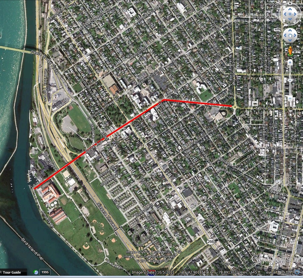
Austin Street is a street in the Black Rock neighborhood of Buffalo, running between the Niagara River and Military Road. The road is about one mile long because the land it originally ran through was the State Reservation, which was a one mile strip of land from the river inland. When the Village of Black Rock was incorporated in 1813, Austin Street was the northern boundary of the Village. The part of Black Rock north of the Scajaquada was often referred to as “Lower Black Rock”, as opposed to Upper Black Rock which Peter Porter originally laid out. Austin Street is named after S.G. Austin, an early Buffalo lawyer.
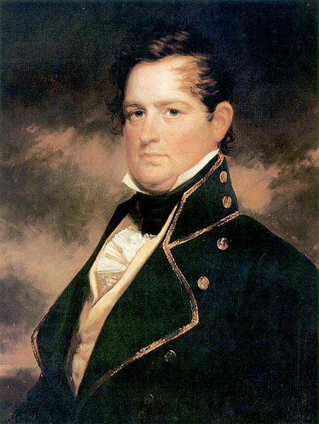
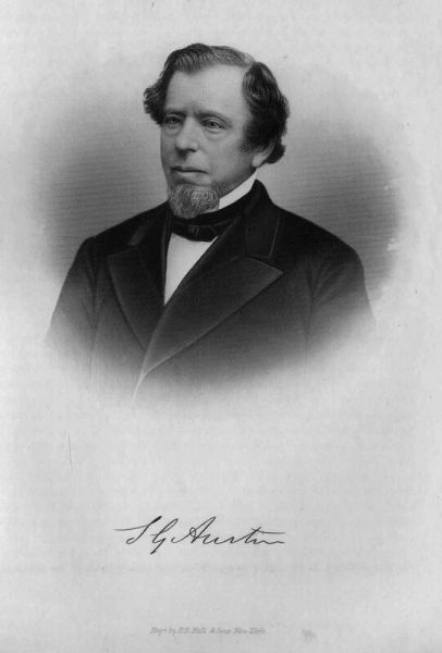 Stephen Goodwin Austin was born in West Suffield, Connecticut to Joseph Austin, a farmer, and Sarah Goodwin, a sea captain’s daughter, in October 1791. He studied at the academy in Westfield, Massachusetts. In 1811, he began his studies at Yale College and graduated with honor in 1815.
After graduation, he began his study of law in the office of Daniel W. Lewis in Geneva. In 1819, he received a license to practice in the State of New York. He then left Geneva and came to Buffalo at the end of 1819.
When he came to Buffalo, the project of creating the harbor for the port was the biggest issue of the day. Mr. Austin saw the future happening here in Buffalo and decided to make the city his home, despite it being a small town of only about 2,000 residents at the time. He boarded at the Eagle Tavern with Millard Fillmore and Joseph Doat. The Eagle Tavern was located at Main and Court Street, the current location of the Liberty Building.
He was often considered as someone who possessed the knowledge, ability, integrity and qualifications for public service, but Mr. Austin never wanted political or other public office. He declined it over the years, time and again. The only office he held was Justice of the Peace for one year, in 1821.
While serving as Justice of the Peace, an important trail came under his jurisdiction. Tommy Jimmy, also known by Tommy Jemmy or his Native American name of So-on-on-gise, was accused of murder. The woman killed, Chaughquawtaugh (or Kauquatau), was a Seneca woman who was accused of bringing about the death of a man using witchcraft. She had fled to Canada. Tommy Jimmy, at the Chief’s request, brought her back home. Once they crossed back into Indian Territory, he killed her. Chief Red Jacket and other Native Americans testified that the act was in accordance with tribal law. Since the land was sovereign land, Justice Austin’s Erie County Court of Oyer and Terminer could not reach a decision in the case. The jury found that the woman was executed in accordance with tribal law. The case was moved up to the Supreme Court. The Court did not render a decision, as the Native Americans had sovereignty over their land.
In the legal field, Mr. Austin was considered a man of clear insight, thorough knowledge and careful judgement. He was perceptive and intellectual. He was sought after as a legal representative and was able to grow a lucrative business. As his business grew, he accumulated a large estate. He had invested much of his savings in real estate from the time he first arrived in Buffalo. Buffalo’s growth rewarded him, as he was able to retire from legal practice at age 52 with a large fortune.
Stephen purchased land on the southeast side of Niagara Square in 1828. Mr. Austin Married Lavinia Hurd in October 1829. They had four daughters, two of which, Adeline and Frances, died in childhood. A third daughter, Lavinia Hurd Austin was born in 1833 and married George P. Russell of Philadelphia. Lavinia Russell died in 1874. The final daughter, Mrs. Truman Avery, aka Delia was born in 1842. (Note from Angela: how annoying is it when women in history books are only listed as “Mrs. Husband’s Name”? Sometimes it’s so hard to find out their first name!! Delia is almost always referred to as “Mrs. Truman Avery” in history books and newspaper articles. I will refer to her Delia from here on out!)
Niagara Square in the days of the Austin Family. Their home is shown to the right of the monument. Erie County Hall can be seen behind the home.
The Austin family lived at 11 Niagara Square, where the Buffalo Athletic Club (also known as the Athletic Club Building) is now. The house was built by Benjamin Rathbun. Mr. Rathbun was one of the early builders of Buffalo and was especially prominent during the 1830s. In 1835 alone, Rathbun built 99 buildings. The Austin house was completed in 1836. The house was the site of lots of entertaining. At the time, Niagara Square was home to homes of many prominent Buffalonians. The square itself was composed of eight triangular fenced in parks and was the most fashionable part of town. The postcard view here would be from after 1914, because the Telephone Building can be seen just beyond Old County Hall. Newspapers report that Mrs. Austin and her daughters were “most accomplished” and they “presided with grace, dignity and charm” over entertainment at the Austin House. After the Austin family left the house in the 1890s, the house was converted for business purposes.
In 1851, a meeting of some of the leading citizens of Buffalo took place at the Austin House. This meeting was the start of the Buffalo Female Academy (now Buffalo Seminary). Both of the Austin daughters attended the Academy.
The Niagara Square house was demolished in 1922 to become the new clubhouse for the Ellicott Club. The Ellicott Club was founded in 1895 and its first home was the top floor of the Ellicott Square Building. On May 22, 1922, the members of the Ellicott Club held a ceremony to celebrate the underwriting of and groundbreaking for their new building. They had a band and marched from Ellicott Square to Niagara Square. The new clubhouse was to be called “The Buffalo Athletic Club” and a new organization was created. The Ellicott Club officially disbanded on March 31, 1923. By 1938, the Buffalo Athletic Club had more than 2,700 members.
The family were members of First Presbyterian Church when it was located on Main Street at Church Street. The Austin Family also gave to many other organizations, but their donations tended to be off the radar because, as a friend was reported saying after Stephen’s death “Little is known of his gifts because of his conviction that charity should not be seen or talked about.”

Lavinia Hurd Austin
Lavinia Austin was a founder of the Buffalo Orphan Asylum. Organizational meetings for the development of the asylum were often held at the Austin house on Niagara Square. Stephen Austin served as the 2nd president of the Orphan Asylum. Lavinia also donated $10,000 to the organization, which allowed for Infant ward addition to be built in 1877. She also left $9,000 to Ingleside Home (a home for unwed mothers and wayward girls) and $5,000 to the YMCA in her will after her death in 1884.
Stephen Austin had significant land holdings in Buffalo. He owned the land northwest of Niagara Square, where several prominent Buffalonians lived, such as Henry Sizer, Darrow Noyes, and Stephen Parrish. The houses were demolished in the 1950s for the Federal Reserve Bank (now New Era Cap) Building.
In 1868, when the National Savings Bank organized, Stephen was voted President. He worked full time at the bank until his death, a position for which he refused to take any salary. He also served as President of the Buffalo Scale Works and owner of the Bennett Elevator, the elevator which replaced Joseph Dart’s original grain elevator in 1863 after the Dart Elevator suffered a fire. It was said after he died that it was rare to see Mr. Austin on the street, because he spent so much time in his work pursuits.
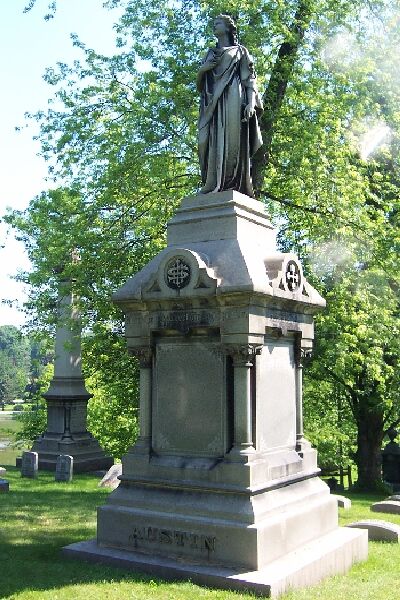
The Austin Family monument in Forest Lawn Cemetery
Stephen Austin died in 1872 and is buried in the Austin family plot in Forest Lawn Cemetery. At the time of his death, his estate was estimated at $2 Million (about $42 Million today). After Mr. Austin’s death, the Niagara Square house was occupied by his wife, along with Delia and her husband, Truman G. Avery. The family lived there until the 1890s.
Lavinia Austin purchased the Universalist Church building at 110 Franklin Street in 1880. Like their home on Niagara Square, the church was built by Benjamin Rathbun. The former church was expanded it and significantly altered. The remodeled building was referred to Austin Building or the Austin Block over the years. This remodel is often credited to her husband in modern local history sources, however it occurred well after Mr. Austin’s death. Newspapers of the time indicate that the purchase and construction/remodeling of the Austin Building was completed by Mrs. S.G. Austin. After its conversion to offices, the building was said to be one of the finest in the city. The offices were elegantly styled and decorated and were occupied by F.W. Caulkins (the architect who designed the remodel), the Buffalo Cement Company, Lee & Zink (a real estate firm), Green & Wicks Architects and other companies over the years. The upper floor consisted of a grand hall, which was occupied by the Academy of Fine Arts (now the Albright Knox). The Academy, as it was known in those days, occupied the entire third floor, one room in the second story and one room in the basement. The hall was lit by skylights from the ceiling to allow as much light into the hall as possible (this was before electricity). The Academy was located here for five years, after which they moved into the Young Men’s Associations new building on Lafayette Square (the old Buffalo Library). Stephen G. Austin, Delia Austin Avery, Truman G. Avery, as well as Delia & Truman’s daughter Lavinia Austin Avery were all life members of the Academy of Fine Arts. The building is currently owned by Erie County.
Stephen Austin owned 204-206 Main Street (often called the Granite Block). Delia took over management of the building after her father’s death. The Granite Block was taken down in 1905 for the Merchant’s Exchange/Chamber of Commerce building. Mr. Austin also owned the building at 302-304 Main Street (now 300 Main Street). The family is shown as owning the 300 Main Street building until at least 1891, so it was likely managed by his wife and daughter after his death. Delia continued in her father’s real estate pursuits, purchasing several properties in her own name. Delia also built a building in 1891 at 77 Pearl Street, adjoining the Merchant’s Exchange building. The Heacock Homestead, home of Reuben Heacock was demolished to build the building. The Austins had purchased the former house in 1876. The last tenant in the home before it was demolished was the Union Veteran Legion. Over the years, Delia’s building on Pearl Street was home to William H. Walker wholesale shoes, Rugby Knitting Mills, the Board of Trade Cafe, and other businesses.
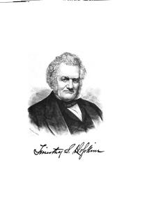
Delia Stewart Austin married Truman Gardner Avery, in 1868. Truman Avery was a lawyer who came to Buffalo from eastern New York State in the 1860s. When he came to Buffalo, he gave up law to work as a grain merchant. Delia had a hard year in 1872, she lost both her father and her first child, Jessie, at 10 months old. Two years later, her sister died. The Austin family owned much of the land where Symphony Circle is located. In 1887, Delia Avery donated the parcel of land at the Circle for First Presbyterian Church in honor of her parents. The church was then able to sell their downtown property for the construction of Erie County Savings Bank and build their current building on the Circle.
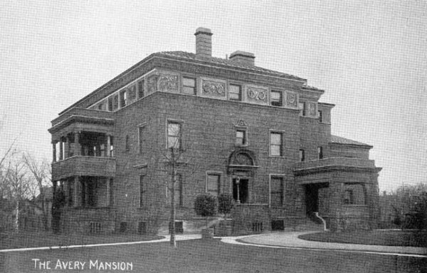
The Avery Mansion on Symphony Circle
After leaving Niagara Square, Delia and her family lived on The Circle (now Symphony Circle) in a large mansion. The mansion was constructed in 1892. Delia served on the board of the Ladies’ Hospital Association at Buffalo General Hospital, the 20th Century Club, and the Home for the Friendless. She was a member of the Daughters of the American Revolution. Delia died in 1922 and is buried in the family plot. Delia followed in her parents charitable footsteps. After her death, it was said that “no worthy cause ever appealed to her in vain”.
Delia’s daughter, Lavinia Austin Avery, was born in 1876 when the family still lived at Niagara Square. Lavinia attended Buffalo Female Academy and the University of Buffalo Teacher’s College and married James McCormick Mitchell in 1907. James Mitchell was the son of Reverend Samuel Mitchell, the pastor at First Presbyterian Church. James worked as a lawyer at the firm of Kenefick, Cooke, Michell and Bass.
After her parents died, Lavinia Mitchell no longer wanted the Avery mansion on The Circle, and offered the 4 acres of land to the Buffalo committee that was working to build a new music hall. Money had been left in the wills of Mr. and Mrs. Edward Kleinhans to create a Buffalo Foundation to be used to build a new music hall. Several locations were looked at for the music hall, including Humboldt Park near the science museum and Delaware Park near the Rose Garden. Architect E. B. Green had even designed plans for an addition to the science museum that would function as a music hall. Residents near Delaware Park opposed the Rose Garden site because they did not want to use park lands for this purpose. The Buffalo Foundation upheld that public parks should be preserved for its natural beauty for recreation and not further encroached upon by public buildings. This stance followed the lead of State Parks Commissioner, Robert Moses, who had also resisted numerous proposals to erect additional buildings in Central Park in New York City. The Buffalo City Planning Board also took a stance to oppose further use of parks for such buildings. The land at The Circle was offered for $50,000 by Lavinia Mitchell, less than half of it’s assessed value. The site offered the spaciousness and beauty of a park location, while allowing for parking but also was bordered by magnificent elm trees, and direct access into the park system via the circle and parkways. It also was on both east-west and north-south bus lines, and had easy access to tourist traffic from the Peace Bridge. The property was officially sold on July 19, 1938 after a large public hearing, at which the public were overwhelmingly in support of the location. The mansion was demolished in 1938 and Kleinhans Music Hall was built. The Circle was renamed Symphony Circle.
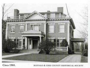
Pomeroy House on Oakland Place
Lavinia and her family first lived on Summer Street, on a house where the Richmond-Summer Recreation Center is now located. In 1911, Lavinia Mitchell purchased the home at 70 Oakland Place (often referred to as the Pomeroy house) from the Pomeroys. Mr. Mitchell died in the 1940s. Lavinia sold the Oakland Place house in 1967 to a developer who subdivided it into three units. Lavinia had been a president of the Garret Club and was on the board of directors of the Twentieth Century Club. She died in 1968 and is buried in Forest Lawn in the family plot.
Want to learn about more streets? Check out the Street Index. Coming in the new year will be a multi-part series about the Fruit Belt on which I have been working hard. Stay tuned! You can subscribe on the home page and new articles will be emailed to you directly.
Sources:
- H.B. Hall & Sons, “Stephen G. Austin,” Digital Collections – University at Buffalo Libraries, accessed November 17, 2019, https://digital.lib.buffalo.edu/items/show/80993.
- Smith, Katherine. “Austin Street Honors Justice Who Presided at Indian Trial”. Buffalo Courier Express, Sunday May 26,
1940, p W8
- Meeting Notices. Daily Courier, April 29, 1851.
- Myszka, Dawn. “Kleinhans Music Hall and its Polish Connection”. Am-Pol Eagle. http://ampoleagle.com/
- “Kleinhans Music Hall: Before the Music”. http://archives.bpo.org/kmh-letc.htm (accessed November 2019)
- Wachadlo, Martin. “Oakland Place: Gracious Living in Buffalo. 2006. https://buffaloah.com/a/oakland/70/wach.html (accessed November 2019)
- H. Perry Smith, editor. History of the City of Buffalo and Erie County. D. Mason & Co Publishers, Syracuse NY. 1884.
- “The Old Church: No Longer in God’s Service, but Used for Business Purposes”. Buffalo Evening News.
- “The Groton Avery Clan”. North America, Family Histories, 1500-2000. Provo, UT: Ancestry.com, 2016.
- “The Art Gallery”. Buffalo Express. June 11, 1881.
- Brown, Christopher. Historic Plymouth Avenue in the Kleinhans Neighborhood. Kleinhans Community Association, 2006.
- “A Seven-Story Fire-Proof Is to be on Pearl Street and Will Be a Credit to Buffalo”. Buffalo Evening News. June 4, 1891.
- “Buffalo Orphan Asylum.” Buffalo Express. August 2, 1924.
- “To Break Ground Monday for New B.A.C. Clubhouse”. Buffalo Courier. May 21, 1922.
- Burr, Kate. “Picturing Some Buffalonians as They Were”. Buffalo Times. July 1, 1928.
- “Ellicott Club to Observe Demise with Celebration”. Buffalo Courier. March 31, 1923. p. 14.
- “Death of Stephen G. Austin”. Buffalo Courier. June 20, 1872. p.1.
- Ball, Charles. “History of Niagara Square”. Buffalo News. May 17, 1921.
- Reports of the President and Secretary, submitted at the Annual Meeting. Buffalo Historical Society. January 9, 1923.
- Chapin, Willis. The Buffalo Fine Arts Academy: A Historical Sketch. Published by the Academy, January 1899.
Read Full Post »
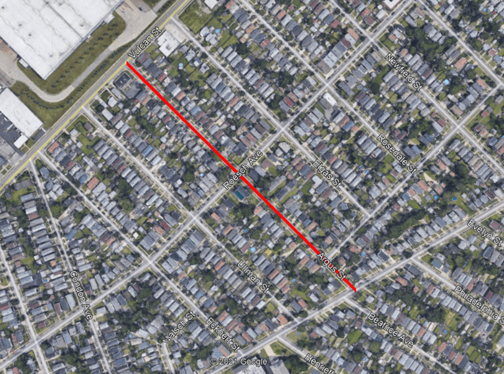 Argus Street is a short street in the Riverside Neighborhood of Buffalo. The street runs two blocks, between Esser Avenue and Vulcan Street. The street is named after Francis (Frank) X Argus, one of the original owners of the land that is now Riverside Park.


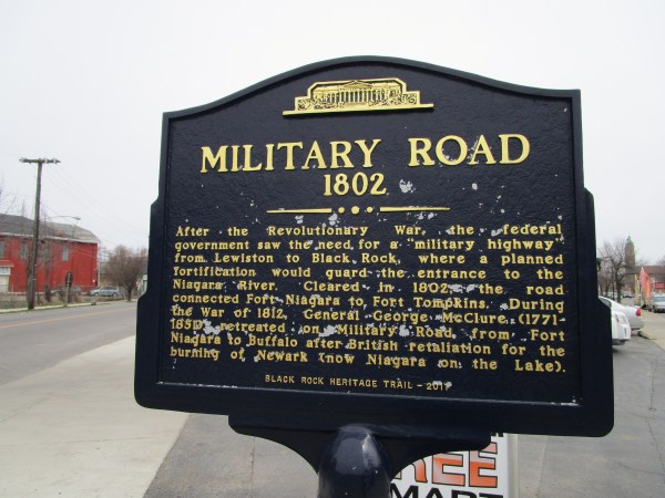
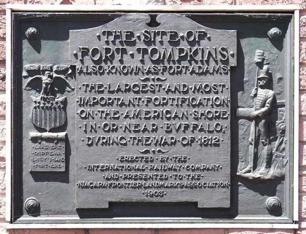 The large fort planned for Black Rock was never built, but a smaller one was built in 1807 and became Fort Tompkins in August 1812. Fort Tompkins was also known as Fort Adams. The fort was actually large mounds which were mounting points for seven guns. It was technically a battery, which is a cluster of cannons in action as a group put into position during a battle of a fort or city. Fort Tompkins was the largest of eight batteries that were built during the war. It was located at the top of the bluff at the bend in Niagara Street. The escarpment here allowed them to overlook the river, giving advantages over the attacks from the water. The location was later the sight of railway barns. A plaque was hung on the railway barn and still hangs on the building located at 1010 Niagara Street. The more famous Fort Tompkins was located on Staten Island and was built in 1663. They were both likely named for Governor Daniel Tompkins, Governor of New York from 1807 to 1817. Fun fact for if you’re ever on Jeopardy: Daniel Tompkins was later President Monroe’s Vice President and the only VP in the 19th century to serve two full terms.