Feeds:
Posts
Comments

Posts Tagged ‘erie canal’

Coit Street

Coit Street

Coit Street is a street in the Broadway-Fillmore neighborhood on the east side of Buffalo, running between Broadway and Howard Street.  The street is named after George Coit, and is only a few streets away from Townsend Street, named after George’s good friend and business partner Charles Townsend (we’ll learn a little about Charles today, and more about him later).  George Coit was called “one of the eminent fathers and founders of Buffalo”.  He resided in Buffalo from June 1811 until his death in May 1865, watching the pioneer settlement rise into a village, rebuild after wartime burning, and grow into a great city.

gcoitThe Coit family arrived in America between 1630 and 1638.  George Coit was born on June 10th, 1790 in Norwich Connecticut.  He learned the druggist business and worked as a clerk in a store with Mr. Townsend (later Judge Townsend) in Norwich.   They came to Buffalo together in 1811 to run a drug store.  For more than 40 years, Mr. Coit & Mr. Townsend worked together in co-partnership.  They quickly were able to buy property at Swan and Pearl Streets, where the built a store.   The day before the Burning of Buffalo, Mr. Coit drove with Mr. Townsend and a wagon full of their goods into Williamsville.  When they arrived back in Buffalo following the burning, they procured a small wooden building on Erie Street which had survived the burning. Their store was in business until 1818, when they sold the business to Dr. John E. Marshall and they entered the shipping business.  They successfully operated several businesses involved in shipping and trade, along with Buffalo Car Works. Their first warehouse was at the foot of Commercial Street, at the mouth of Little Buffalo Creek, where they built a dock and a frame building.  Mr. Coit married a sister of Mr. Townsend, Hannah, on April 4th, 1815.  Hannah and George had eight children:  Sarah Frances, Charles, George, John, Frances, Nathaniel, Eliza, and William.

Wedding of the Waters at the Buffalo History Museum...depicting Governor Dewitt Clinton with Samuel Wilkeson, George Coit and Charles Townsend at the opening of the Erie Canal

Wedding of the Waters at the Buffalo History Museum…depicting Governor Dewitt Clinton with Samuel Wilkeson, George Coit and Charles Townsend at the opening of the Erie Canal

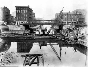
In 1818, Mr. Coit, along with Mr. Townsend, Samuel Wilkeson and Oliver Forward, secured a bond and mortgage for a state bond for the construction of the Buffalo Harbor.  By 1821, the channel was deep enough to allow for vessels, proving the Buffalo Harbor was successful, despite many people’s concerns about their experiment to build the harbor.  The four men worked together to build the harbor and lobby the legislature to ensure that Buffalo would be the terminus of the canal, not Black Rock.

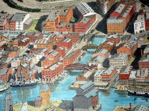
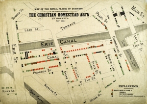
During the Canal-era, the Buffalo waterfront was a slew of various slips, many owned by private businesses.  The Coit Slip was located near the end of the Erie Canal.approximately parallel to Erie Street.  The slip was filled in when the Erie Canal was filled in during the 1940s, but a portion remains behind Templeton Landing (formerly Crawdaddy’s/Shanghai Reds).  The land around the Coit Slip was owned by Mr. Coit and Mr. Townsend.  The Coit Block/Coit Building (also referred to as the McCutcheon Building) was located at the southern end of Commercial Street adjacent to the western edge of the Commercial Slip.  The Coit Building was located there from pre-1840 until its razing around 1947.  Portions of the Coit Building’s foundations and other features were uncovered during the archaeological investigations during the Erie Canal Harbor project (which created the Commercial Slip and Canalside).  The recreated building housing the Buffalo and Erie County Naval and Military Park and Museum was built on the site in 2008.

Map Showing Different Canal Era Slips. For reference, Erie Street's alignment has shifted towards the south. Commercial Slip is the one that has been uncovered at Canalside (click to view at higher resolution)

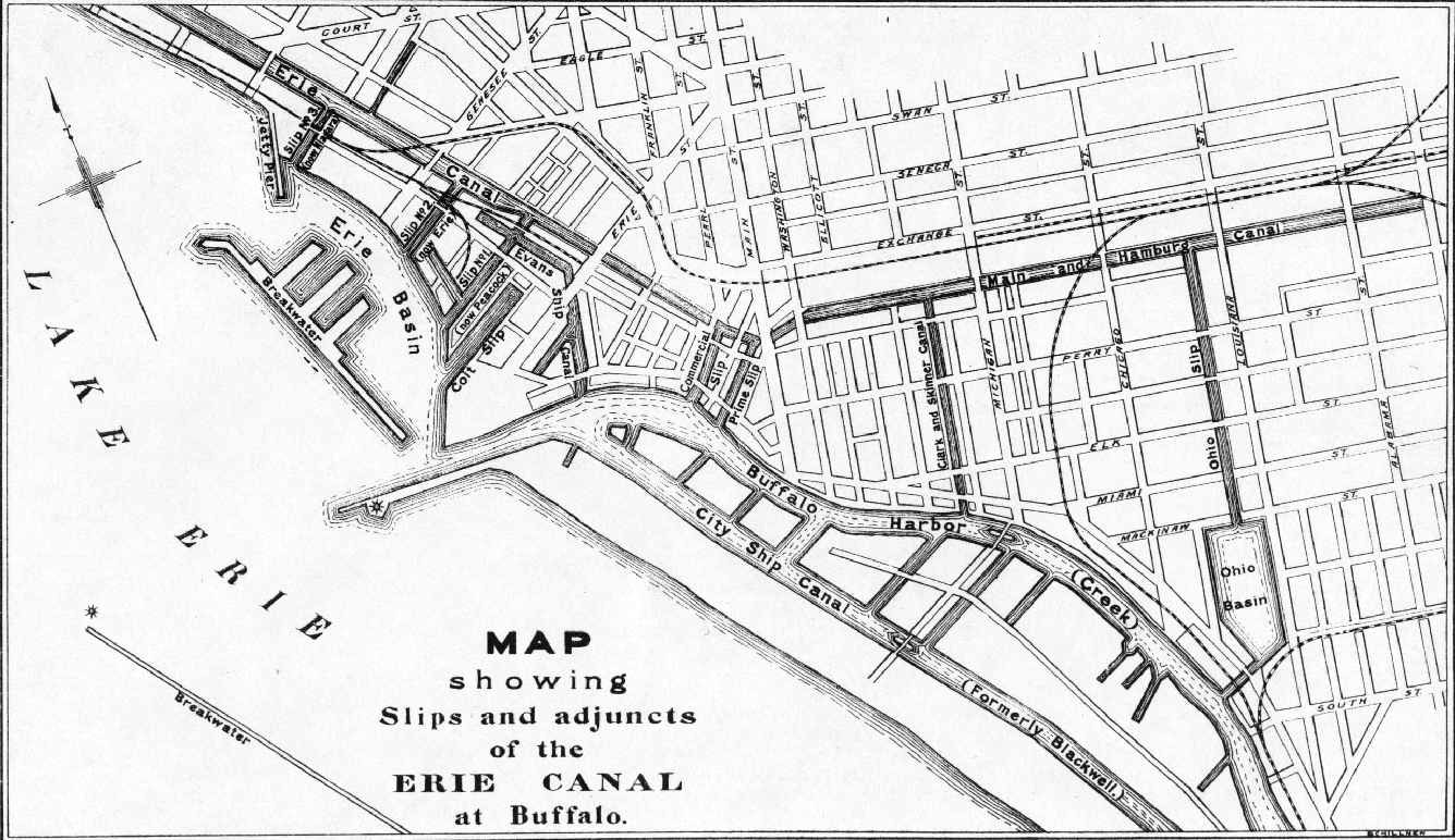
Map Showing Different Canal Era Slips. For reference, Erie Street’s alignment has shifted towards the south. Commercial Slip, near the center of the map, is the one that has been uncovered at Canalside 
(click to view at higher resolution)

Mr. Coit was a member of the Buffalo Historical Society, the Buffalo Board of Trade, the Buffalo Water Works Company, as well as other organizations.
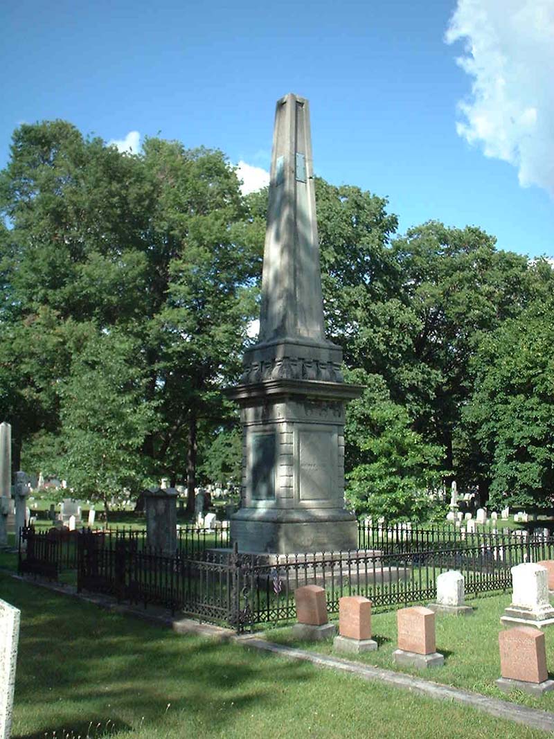
George Coit's Grave

George Coit’s Grave

Mr.  Coit died in May 1865 and is buried at Forest Lawn.  More than 50 Coit relatives are buried in the plot near George’s grave.  At a memorial before the Buffalo Historical Society in July 1865, Mr. William Ketchum said this about Mr. Coit:  “Although Mr. Coit had lived to see Buffalo grow up from an insignificant village to become a large and populous city, his own chosen dwelling being, as it were, in the very heart of business, he preferred to remain in his old home, and continued to occupy his plain, unpretending residence on the corner of Pearl and Swan Streets, where he had first pitched his tent more than 50 years ago”

Coit House

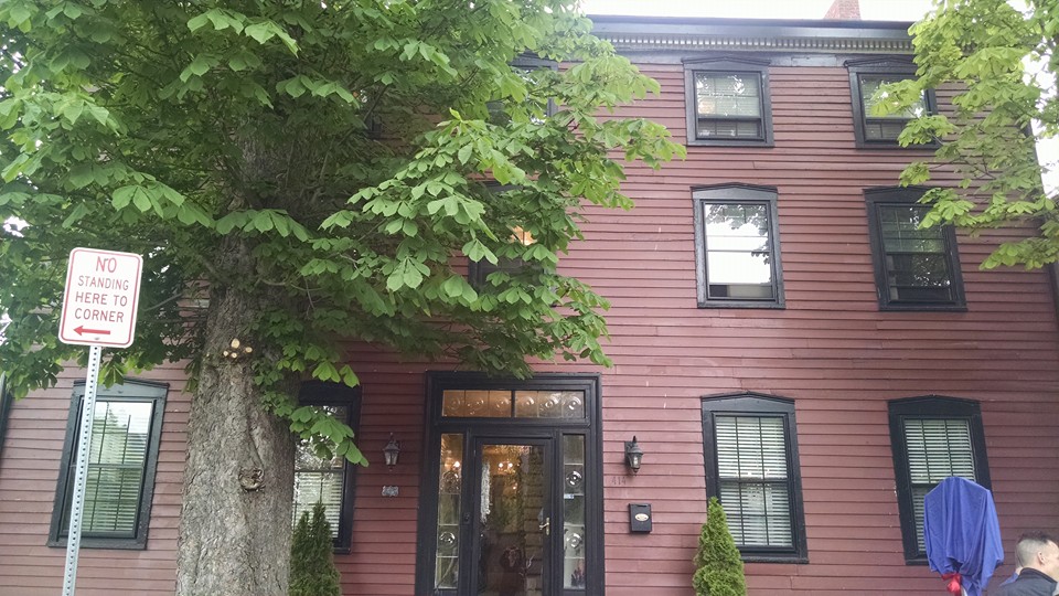
The Coit House on Virginia Street

The house which Mr. Coit had built is still standing here in Buffalo today and is considered to be the oldest house in Buffalo.  The Coit House is estimated to have been built around 1818, shortly after the Burning of Buffalo in 1813/1814.  The house was originally located at 53 Pearl Street.  The house was moved around 1867 to its current location on Virginia Street between Delaware and Elmwood Avenues.  The house had seem some changes over the years, including being converted into apartments, but has been restored to relatively close to the original layout of a single family home.

In May of 1962, the Coit House was improved by a group who wanted to help the neglected building.  Organizations such as the Buffalo Chamber of Commerce and the City of Buffalo Division of Conservation worked with volunteers to repair clapboard, paint the building and trim the trees.   During the late 1960s, the building was slated for demolition as a part of the Allentown-Lakeview urban renewal project.  This prompted the creation of the Landmark Society of the Niagara Frontier in May 1969.  The Landmark Society worked to restore the building and then help to sell the building to a new owner with a deed stipulation that would prohibit modification of the historic restoration of the building.   The house was purchased by Henry and Linda Priebe, who lived there for nearly 30 years.  The house went back on the market in 1999 when it was purchased by the Allentown Association.  Major renovations were completed on the building, which was then purchased by Gerhart Yakow, and is now owned by Tim Boylan and Sue-Jolie Rioux Boylan.  It’s a beautiful building and if you get a chance to visit, you should take the opportunity!  The wide plank boards in the floor on the third floor will make anyone interested in history and/or architecture swoon.  The Boylans are wonderful stewards of the building, you can tell they care very deeply about the history and heritage of the house.

One of the best parts about writing this blog is the feedback I receive from my readers.  While I can’t always respond to it all, I appreciate every single one of the comments, messages and feedback I receive.  I’ve had descendants of some of the families reach out to me; I’ve had people email me photos, mail me prints, and I love all of it.

I first “met” Coit family member Susie Coit Williams about four years ago, when she first commented on my blog.  We’ve emailed back and forth, as she was trying to get a historic marker at the Coit House.  The marker finally was installed and was dedicated during an unveiling ceremony on May 21st, 2016!  Here are some photos from that event!

Mayor Brown and Councilman Fronczyk proclaiming it George Coit Day in Buffalo!

Mayor Brown and Councilman Fronczyk proclaiming it George Coit Day in Buffalo!


Susie Coit Williams unveiling the historic marker

Susie Coit Williams unveiling the historic marker

Coit House finally has a historic marker!

Coit House finally has a historic marker!

It was a great opportunity to celebrate the history of George Coit, whose story is so ingrained in the fabric of the City of Buffalo!  It’s excited to know that the house is in good hands for the future, and that Mr. Coit’s life is remembered for all who pass down the street!  Take a walk by and check out the marker and think for a moment on Mr. Coit and the life he lived here in Buffalo.

To learn about other streets, check out the Street Index.


Sources:

  1. Smith, H. Perry.  History of the City of Buffalo and Erie County.  D. Mason & Co Publishers:  Syracuse.  1884.
  2. Brown, Christopher.  The Coit House Mystique.  June 2007.
  3. Grasso, Thomas.  The Erie Canal Western Terminus – Commercial Slip, Harbor Development and Canal District.  Erie Canal Harbor Development Corporation.


Advertisement

Read Full Post »

hoytstreetHoyt Street is a street within the Elmwood Village neighborhood of the West Side of Buffalo.  The street runs between Ferry Street and Forest Avenue, parallel to Elmwood Avenue and Grant Street.   Interestingly, there was historically an earlier Hoyt Street.  The original Hoyt Place was located west of the Buffalo State Hospital (now Richardson Complex) and is now known as Bradley Street.  The street was renamed likely around the same time that the Hoyt Street we know today was developed, during the 1880s.  Bradley Street is shown in orange on the map to the left, while Hoyt Street is shown in red.

Erie Canal Survey showing Joseph D. Hoyt's Land

Erie Canal Survey showing Joseph Hoyt’s Land

The historic Hoyt Place was named after Joseph Dibble Hoyt, the original land owner of the property Hoyt Place/Bradley Street was developed on.  Joseph Hoyt was born on December 23, 1785 in Danbury, Connecticut.  He was the child of Moses Hoyt and Amerillas Dribble.   In 1811, he moved to Buffalo, NY.  During the War of 1812, he was taken prisoner of war during the Burning of Buffalo by the British and Native Americans.  He was imprisoned in Montreal.  After the war, he returned to Buffalo and became a prominent and influential citizen.  Mr. Hoyt owned a tannery on Carroll Street, which was originally called Tan Alley because of the tannery located on it.

Mr. Hoyt married Sarah St. John in 1809, they had one child, Harriet Hoyt.  He later married Polly Wright in 1814.  Mr. Hoyt died in 1838 and is buried in Forest Lawn.  I’m not sure that these Hoyts are related to Buffalo’s other Hoyt family, but perhaps someone more familiar with the family’s genealogy would be able to say for sure.

William Ballard Hoyt

William Ballard Hoyt

Hoyt Street is named after William Ballard Hoyt.  William Hoyt was born in East Aurora on April 20th, 1858.  He was the son of Doctor Horace and Josephine Ballard Hoyt.  He attended the Aurora Academy and Buffalo High School.  In 1877, he entered Cornell University to study history and political science.  After graduation, Mr. Hoyt came to Buffalo and entered the firm of Humphrey and Lockwood.  He was admitted to the bar in March 1883, and the firm became Humphrey, Lockwood & Hoyt.  The firm went by several different names as partners changed.  Mr. Hoyt and his firm served many prominent industrial and business concerns in Buffalo, such as New York Central, Vanderbilt properties, Western Union Telegraph Company, Western Transit Company and others.  Along with Mr. Baynes (more about him on a different day), Mr. Hoyt developed several of the streets around the street that bears his name.

In 1886, Mr. Hoyt became Assistant United States Attorney for the Northern District of New York, serving in this position until 1889.  In 1894, he was appointed as counsel to the United States Interstate Commerce Commission for the States of New York and Ohio.

Mr. Hoyt served as Director of the Buffalo Club for six years, Curator of the Buffalo Library for three years,  and was a member of the Board of School Examiners and President of the Cornell Alumni Association.

In 1887, Mr. Hoyt married Esther Lapham Hill.  The Hoyts had five children – John, Josephine, Esther, Albertine and Hilda. Mr. Hoyt died in 1915 and is buried in Forest Lawn Cemetery.

william grave


Captain Hoyt

Captain Hoyt

Mr. Hoyt’s son Captain John Davidson Hill Hoyt was born in 1898 in Buffalo.  Captain Hoyt served in the Air Corps US Army. In 1936, he served as president of the Buffalo Niagara Association of Realtors.  He was killed in a crash off the coast of the Hawaiian Islands along with nine other crew members in January 1943.  Captain Hoyt has a marker among the Courts of the Missing from WWII in Honolulu and also a marker in Forest Lawn Cemetery.

john grave

Captain Hoyt Grave-marker


Bill Hoyt on the NYS Capital steps in the 1970s

Bill Hoyt on the NYS Capital steps in the 1970s

Captain Hoyt’s son William B. Hoyt II was born in 1937 in Buffalo.  He was educated at the Park School of Buffalo and Hamilton College.  He taught history at Park School for 11 years before entering politics.  He served as a member of Buffalo Common Council from 1970 to 1974.    William II ran unsuccessfully for Mayor of Buffalo in 1989, when he was defeated by James D. Griffin.  He served as  New York State Assemblyman for the 144th District from 1974 until 1992.  Mr. Hoyt died of a heart attack on the Assembly floor during a vote.

During his time on the Common Council, Mr. Hoyt proposed a plan to clean up the lake in Delaware Park.  He became a champion for the Lake.  Following his death, the lake was named Hoyt Lake in honor of William B. Hoyt II.

Hoyt Lake in Delaware Park

Hoyt Lake in Delaware Park

sam

Sam Hoyt

William II’s son, William B. Hoyt III, known by most Buffalonians these days as Sam Hoyt, was born in January 1962. Sam Hoyt attended local schools, graduating from Park School of Buffalo and attending Buffalo State College for political science.  Sam served as the WNY regional director for U.S. Senator Daniel Moynihan and director for the Buffalo Bisons.  In 1992, he took over the 114th District of the New York State Assembly, filling his late father’s seat.  He served in the Assembly for nearly 20 years prior to resigning in 2011 after being appointed as Regional President of the Empire State Development Corporation.  He also serves as Chair of the Buffalo and Fort Erie Peace Bridge Authority.

In 2004, Sam proposed that a group be created regarding the restoration of the historic H.H. Richardson Complex for use as for a cultural and educational activities, proposing that $100 million be put towards the restoration.  The progress on the Richardson Complex has been moving along, and the Hotel, Conference Center and Architecture Center are expected to open in 2016.  (Author’s aside:  I was interning for Sam during this time, and the Richardson building became my favorite building in Buffalo, as I fell completely in love with it when I first stood up on its steps during a press conference to announce the funding from the State.  Of Sam’s many accomplishments, I consider this to be my favorite, so I’m including it here.)

Think of the various generations of the Hoyt family the next time you go for a walk down Hoyt Street or take a walk around Hoyt Lake.  Maybe in a few years, I’ll have to update this entry to write about Sam’s sons!

Check out the Street Index to learn about other streets.


Sources:

  1. A History of the City of Buffalo:  Its Men and Institutions.  Published by the Buffalo Evening News:  Buffalo, 1908.
  2. Our County and its People:  A Descriptive Work On Erie County, New York.  Edited by Truman C. White.  Boston History Company:  1898.
  3. Buffalo Past and Present:  A Manual of Buffalo and the Niagara Frontier.  Reinecke & Zesch:  1994.
  4. Downs, Winfield Scott.  Municipality of Buffalo, NY:  A History.  1923.
  5. Memorial and Family History of Erie County, New York.  Genealogical Publishing Company.  1906.
  6. A Genealogical History of the Hoyt, Haight, and Hight Families: http://trees.ancestry.com/tree/36692239/person/20396668475/storyx/bb957757-2690-46ba-b30f-952be9ecd35e?src=search)
  7. http://www.bnar.org/about_us/past_presidents/index.html

Read Full Post »

Marine Drive depicted in red.  Canal District depicted in blue.

Marine Drive depicted in red. Canal District depicted in blue.

This post is the third and final park in a series on the history of Buffalo’s Canal District.  Click here to read Part One, about the early days of the Canal – the Canal Street era.  Click here to read Part Two – the Dante Place era.  Today’s post is about the Marine Drive era of the Canal District.  Marine Drive replaced Dante Place during the 1950s.  Marine Drive stretches from Main Street to Erie Street and forms a loop, intersecting upon itself after circling around the Marine Drive Apartments.  If you zoom in far enough on online maps, you’ll see that a small part of Marine Drive still holds its claim as “Dante Place”, at least according to google!

Little sliver of Dante Place (top center part of picture) still shows up in Google!

A little sliver of Dante Place (top center part of the picture) still shows up in Google!

Plans were developed to build “Fairhaven Village”, a private development for 1,078 middle-income families.   After a building explosion in 1936 and the 1936 State Law allows cities the right to condemn and remove “unsafe and unsanitary” buildings,  buildings began to be demolished.  Approximately 500 families moved out of the neighborhood in the summer of 1937.   It was to be one of the first slum clearance rehabilitation projects in the Country.  Early plans for Fairhaven Village  in 1938 called for accommodations for 962 families with a total of 2,942 rooms.  The apartments were to include a 500 car garage to be built below grade of the apartments.  The apartments were to average $17.50 a room, including hot and cold water, gas, electricity and refrigeration.  It was going to be the first project of its kind to be privately owned, managed and financed.    At the time, there was a rental shortage in Buffalo, and reports estimated that there were close to 7,000 families living doubled (or tripled) up in apartments meant for one family.   However, the effects of the Great Depression and later wartime restrictions limited the construction funds to build the development.

Evans Street Demolition 1950s.  Note City Hall in the rear background of the photo.

Evans Street Demolition 1950s. Note City Hall in the rear background of the photo.

After WWII, the Buffalo Municipal Housing Authority began plans for low-income housing in the Dante Place district, despite local opposition.  In 1948, 90 families were displaced by the State for construction of new housing, which began in 1950.  The Dante Place Projects were completed in 1952, residents moved in during September of that year.   The seven 12-story buildings were the first permanent state-aided housing in the City of Buffalo and consisted of 616 units.  Each building contains a mix of one, two, three, and four bedroom apartments.

Photo from the Courier Express - 1950 during demolition for construction of the Dante Place Project

Photo from the Courier Express – 1950 during demolition for construction of the Dante Place Project

When the Dante Place Project was in its planning stages, Howard Kelly of the Municipal Housing Authority stated:  “We hope that this will be the first step of a waterfront beautification program which will continue right through to Porter Ave”.

Ad for bathtubs installed in Dante Place Project

Ad for bathtubs installed in Dante Place Project

Dante Place Project tenants protesting their eviction.  Source:  Artvoice

Dante Place Project tenants protesting their eviction. Source: Artvoice

By 1960, many of the tenants of Dante Place Project were those displaced from condemned substandard housing on a the Lower East Side of Buffalo, a historically black section of the City.  The Dante Place projects had become again considered to be a slum area.  The BMHA was losing money due to unfilled apartments.  The BMHA responded by moving low-rent residents back to the Douglass Towers and the Ellicott and Talbert Mall.  This was the first attempt in the country to convert public low-cost housing into privately owned development.  The tenants formed the Dante Tenants Defense League to represent the 400 families remaining in the project and fight the evictions.  In 1960, the group went to the state housing commissioner, but they were unsuccessful fighting the conversion of the complex.   New York State Supreme Court Judge Catalano ruled in October 1960 that the conversion was not in violation of New York Public Housing Law.

1951 Aerial view of the Canal District

1951 Aerial view of the Canal District – Dante Place Project/ Marine Drive Apartments shown in center

By 1961, Dante Place resembled what had been originally been proposed as the Fairhaven Village – converting the complex from public housing to subsidized moderate income rental apartments.  A $300,000 remodel was completed and the apartments were rented out.  This project was the first time in the United States that a low-income housing project was converted into a private non-profit middle-income apartment development.  Once the new complex reached 92% occupancy, the tenant stockholders elected a board of directors and officers to manage the development.  The complex was renamed Marine Drive Apartments.

When planning for the Dante Place Projects, there was a great discussion among the City Planning Board members regarding what to name the new street.  Councilman John Ramunno argued for the new street to be named “Dante Place” to keep with the history of the neighborhood.  However, the Council President and others protested because they wanted a new name that did not have a connection to the past, the history of the neighborhood, or the Italian culture that it represented.  The Council eventually voted in favor of removing ties to the “old environment” and Marine Drive was named due to the waterfront neighborhood’s location.

As part of the Downtown Urban Renewal Plan, development of the Waterfront Village began.  The first condos opened in Waterfront Village in Summer 1972.   In 1974, the Erie Basin Marina was completed, built by slag from Bethlehem Steel.  The gardens at the Marina were developed by Stanley Swisher, supervisor of the grounds for the City’s Engineering Department.  Stanley Swisher would plant a new bed of perennials each year.

In 1979, the Buffalo Naval and Servicemen’s Park opened.  The original display included the USS Little Rock and the USS The Sullivans.  In 1988, the submarine the USS Croaker was added to the display.

Other than the Marine Drive Apartments and Waterfront Village, since the 1950s, much of the Canal District sat vacant and silent.  The Central Wharf and the Commercial Slip were buried and covered in stone and parking areas.

2002 Aerial View of the Canal District

2002 Aerial View of the Canal District

Buffalo and Erie County Naval and Military Park

Buffalo and Erie County Naval and Military Park

In 1999, as part of Phase I of the Erie Canal Harbor plan, the Naval Park moved as part of a $15.5 million dollar improvements to the Erie Canal Harbor.  Memorials were moved to the newly created Veteran’s Park.  The USS Little Rock, the Sullivans and the Croaker were repaired and moved to the new Naval Basin.  The existing esplanade facilities were enhanced and expanded to create a continuous walkway along the edge of the water.

Canalside

Canalside

The Erie Canal Harbor Development Corporation was created in 2005 to help restore economic growth to Buffalo and WNY’s waterfront.  Phase II of the Erie Canal Harbor plan was completed in 2008 and included the re-watering of the Commercial Slip, a towpath/walkway on the edges of the slip, construction of a bowstring truss bridge, the reconstruction of Commercial Street, Lloyd Street, Perry Street and Hanover Street, and the uncovering and preservation of the Steamboat Hotel and Lloyd street as an archeological site.  A wooden wharf was created, along with floating docks.  This area is referred to as Canalside, a 20-acre part of the historic Canal District. Canalside has been successful in drawing people down to the waterfront – offering programming, events, festivals and other attractions.   Canalside has more than 750 events and 750,000 visitors annually.

Demolition of the Aud

Demolition of the Aud

Memorial Auditorium closed in 1996, when the Buffalo Sabres, Blizzards and Bandits moved across the street to the newly built Crossroads Arena (now First Niagara Centerclick here to learn more about the name of the Arena).  Plans to renovate and repurpose the Aud were shuffled around for years, including the reuse of the Aud as a Bass Pro site.  In 2007, the Aud was sold by the City of Buffalo to ECHDC.  Salvageable items were removed to be sold, stored or removed.  Asbestos removal and environmental remediation of the Aud site was performed in 2008 and demolition began in January 2009.  A farewell ceremony was held June 30, 2009 to open the time capsule from 1939 and say goodbye to the Aud.

The Aud Block is currently being redeveloped, which includes development parcels based on the historic street grid.  One of the parcels will be developed by the Explore and More Children’s Museum.  Additional restaurant and public spaces are anticipated to be developed as well.  Water features on the Aud Block will be interpretations of the alignment of the Erie Canal, Main and Hamburg Canal, and the Commercial Slip.  Across Main Street on the Donovan Block, south of the newly opened One Canalside, a portion of the canal water feature will be included, as well another development parcel.  These projects, along with Harbor Center, will create the next phase of the Canal District’s development.

2011 View of the Area, showing the rewatered commercial slip, recreated historic street pattern an demolished Aud site

2011 View of the Area, showing the rewatered commercial slip, recreated historic street pattern and the demolished Aud site

Buffalo’s Canal District has been a unique part of Buffalo’s story since the founding of the City of Buffalo.  The district has had several lives – from seedy underbelly, Little Italy’s crowded tenements, public housing, to sitting dormant and the recent redevelopment. As Canalside continues to be developed, the story will continue to unfold.  I can’t wait to see what comes next!

Check out the Street Index to read about other streets.

Sources:

  1. “Housing Project Rises wehre Canalers Roistered” Courier Express 10-29-1952
  2. “Lusty Canal St. Lived Hard and Fast in Heyday” Courier Express 10-26-1952
  3. “Dante Area Streets Get Single Name” Courier Express, November 11, 1960 Buffalo Streets Vol 1.
  4. America’s Crossroads:  Buffalo’s Canal Street/ Dante Place.  Buffalo NY Heritage Press, 1993.
  5. Dug’s Dive.   Buffalo Express Saturday Morning August 29,1874
  6. Hart, Mary Bronson.  Partitioning Poverty:  Zones of Influence in Social Work.  Boston Evening Transcript.  August 29, 1900.
  7. Syracuse, Buffalo Illustrate Broadened UR Concept.  The Evening News.  Newburgh, NY.  August 9, 1961.
  8. Yans-McLaughlin, Virginia.  Family and Community:  Italian Immigrants in Buffalo, 1880-1930.
  9. First Tenants to Move into Dante Project.  Buffalo Courier-Express.  August 31, 1952.  8-A.
  10. Crowbars End Lurid History of Slum Area.  Buffalo Courier Express.  July 11, 1948.
  11. Move to Clear Buffalo Slum Area Launched.  Buffalo Courier Express.  October 2, 1936.  p 7.
  12. Dante Tenants Fight Eviction.  Baltimore Afro-American.  August 30, 1960.
  13. Queen City Waterfront Plan

Read Full Post »

This post is the first in a series of three posts about one street that still exists – Marine Drive – and several streets that no longer exist – most specifically Canal Street and Dante Place.  These streets are a part of Buffalo’s old (and new) Canal District.  The Canal District contains some of Buffalo’s most fascinating stories.   Today’s post will deal with the district when it was known as the Canal Street area.  Part Two will come out on Friday April 4th and deals with the Italian Immigrant era, when it was known as Dante Place or “The Hooks”.  Part Three will come out next week and deal with the last 60 years of the area’s history – the Marine Drive apartments and Canalside.

The Canal District consists of the area along Buffalo’s inner harbor, which today is located south of the I-190, between Main Street and Erie Street.  Here is a current view of the area we’re discussing:

View from 2011

View from 2011

The area, with the success of Canalside, is quickly becoming one of the success stories for Buffalo.  The area has a long and fascinating past, some of which is represented by the ruins of canal era buildings along the Commercial Strip today.  In 1950, the Buffalo Evening News wrote of the area:

Old Canal Street – Dante Place for the past quarter of a century – lies doggo this spring. Its days are numbered. Of some ordinary street it could be said it is dreaming of its past stories – but not Canal St – the old rip. If anything, Canal St. is like an ancient burned-out roue reflecting on a disreputable past. Canal Street and some of its immediate purlieus like Maiden Lane, and Peacock Street have empty houses with the windows bashed out. The old plaster in old rooms is broken and crumbling. Along the streets are old house numbers – 148, 156 – corroded and painted over and beaten by the weather of a hundred years. There is the occasional iron rail across what was once a barroom window, to protect it from stumbling drunks and lolling roustabouts. These are the flotsam and jetsam of an era long gone – a rough and roistering era of hard men and fancy women, of the waterside of Buffalo when it was young and heady with liquor, laughter and love at voyage end. It was the days when the canaler could sing that “The Erie was a-risin‘, the gin was gettin‘ low, and I scarcely think we’ll have a drink till we get to Buffalo”. It was the days when the sailors, swinging off their brigs and barks and ready for a fight or frolic, could yell: “Canaler, canaler – you’ll never grow rich; you’ll die in the ditch”.

dug in his dive_gif

Dug’s Dive Illustration

Canal Street was only two blocks long, running between Commercial Street and Erie Street.  The street was called “the wickedest street in the world”.   It was said that, during its heyday, there was a murder every day. Legends were told of saloon owners who would serve a poisoned drink, steal a man’s clothes and personal items, and dump the body in the canal.  The supposed first “dive bar”, Dug’s Dive was located along the canal, down a steep set of slippery steps from the towpath, so patrons sometimes “dived” into the bar.  The proprietor of Dug’s Dive was William Douglas, a former slave.

Canal Street was a busy place, due to its location on the waterfront. The Canal folk met the sailors from the Lake.  In 1829, when the road was laid out, it was known as Cross Street because it crossed several of the short streets between Commercial Street and Erie Street.   Other streets in the area were Peacock, Fly, Water, Hanover, LeConteuix, Evans, Lake, Lloyd and State.

 In 1847, it was written in the Buffalo Republic:

During the summer, the very worst class of people inhabiting this portion of the first ward, have been permitted to gather there in unusual numbers, publicly enacting the most disgusting scenes, rioting by day and reveling by nightIf the canal could speak, and its waters cast up the hidden bodies of those who have doubtless come to an untimely end, its tale of horror would startle the public mind, and those whose duty it is to  look after the public peace of our city, might feel and realize how great this has been of their omission of duty.

Depiction of the Canal Street Area

Depiction of the Canal Street Area

By 1854, the canal had become supreme in the district, and the name was changed to Canal Street. The street was a busy place – The Erie Canal connected under Main Street with the Main-Hamburg Canal, running east to connect with the Clark-Skinner Canal, which started around Chicago Street and ran south to the Buffalo River. On the lake were the Prime, Coit, and Niagara slips, among others.  The Canal Street district of the city was bounded by The Terrace, Lower Main Street, Erie Street and the harbor.  The Canal Street district was connected to the rest of Buffalo by foot and wagon bridges over the Canals.  Maiden Lane got its name from the early days of Buffalo when the young women said goodbye to their sailor sweethearts or welcomed them home from voyages.

The Canal District quickly established itself with bars and taverns to entertain the canal workers.  Along with the taverns came gamblers, drunks and working girls.   Long nights of drinking and brawling turned the area into a crime-ridden district.

The Canal District was often referred to as the “infected district”, both due to the low moral standards in the area and due to the diseases that ran rampant  syphilis, chlamydia as well as diphtheria, scarlet fever, whooping-cough and the flu.  The Express described the area as containing “broken down hovels of ill-fame, presided over by ill-favored hags, who have long forfeited their right to the name of women”.    The saloons were profitable enterprises for many Buffalonians.  When early reformers and settlement houses tried to come in, they failed to lure the men away from the saloons.  The saloons of the time functioned as a labor bureau, a post office, a source of credit, a political headquarters, an ethnic gathering place, and a spot where a man could get a free lunch along with his beer.

1893 Map from the Christian Homestead Association of the "Houses of Ill-Fame" in the Canal District

1893 Map from the Christian Homestead Association of the “Houses of Ill-Fame” in the Canal District  (Source:  Rare Book Room of the Buffalo and Erie County Public Library)

The song “Buffalo Gals” was written by John Hodges in 1844 and refers to the women who lived in the canal district.  By the 1880’s, it was said that there were as many as 400 women “of easy virtue” in the Canal Street section of the City of Buffalo.  Included in the district were 93 saloons, 15 concert-hall dives, and hundreds of dance-hall girls.  While Grover Cleveland was Sheriff in 1870, Cleveland had tried to clean up the place, but was unsuccessful.  Many of the women were employed by the saloons as “cooks” but were on hand to provide companionship to the men of the barges. These women of the district were not allowed to go further uptown than the Liberty Pole, which was located near where the Memorial Auditorium was later located.  Once a week, the women were allowed to go into town to go shopping.

During the Pan-American Exposition of 1901, a number of women from New York City came to the canal district, attempting to make money off visitors to the Pan-Am. They planned to take the “Buffalo Gals” out of their territory by bringing their worldliness to the area. Before the Pan-Am, there were 500 Buffalo women living in the Canal district.  The ladies of Canal Street resented the NYC women, and joined forces and attacked the NYC women with clubs, knives and fists, chasing the NYC women out of Buffalo.  The NYC women were escorted by police back to NYC on packet boats and trains.

Commercial Street Bridge Over Erie Canal, 1926

Commercial Street Bridge Over Erie Canal, 1926

In 1895, the Erie Canal was deepened and shortened.  Newly built railroads were built, which were more efficient in moving goods across distances with greater speed and power.  The changing transportation landscape began to change the neighborhood.  Immigrant families began to settle in the area.   The rule limiting the women of Canal Street from venturing north into Buffalo proper was lifted.  These ladies “of the fancy ways” began deserting the area. The vice they represented moved to other areas in the city, including the red light district of Vine Alley (located between Elm and Oak -the area was razed in the 1920s when William Street was extended from Michigan to Broadway). After the women left, the saloons and concert halls began to close.

Stay tuned for Part Two, which will discuss the Canal District’s transition into Dante Place, coming out on Friday April 4th.

Learn about other streets by checking out the Street Index.

Sources:

  1. Courier Express Dec 17, 1952 p 15
  2. “Echoes of Revelry Have Faded out and Earth-Movers Clang Away. Buffalo Evening News 4-15-1950
  3. “Housing Project Rises where Canalers Roistered” Courier Express 10-29-1952
  4. “Lusty Canal St. Lived Hard and Fast in Heyday” Courier Express 10-26-1952
  5. “Dante Area Streets Get Single Name” Courier Express, November 11, 1960 Buffalo Streets Vol 1.
  6. America’s Crossroads:  Buffalo’s Canal Street/ Dante Place.  Buffalo NY Heritage Press, 1993.
  7. Dug’s Dive.   Buffalo Express Saturday Morning, August 29,1874
  8. Hart, Mary Bronson.  Partitioning Poverty:  Zones of Influence in Social Work.  Boston Evening Transcript.  August 29, 1900.
  9. Yans-McLaughlin, Virginia.  Family and Community:  Italian Immigrants in Buffalo, 1880-1930.
  10. Nicolosi, Rachel.  Love for Sale:  Prostitution and the Building of Buffalo, New York, 1820-1910.  The Exposition:  vol 2, Issue 1. 2014.

Read Full Post »

joseph ellicottThis is the third and final part in a series about Joseph Ellicott.  Click here to read Part One about Joseph’s family and his early life.  Click here to read Part Two, about Joseph’s days with the  Holland Land Company.  Today, I am going to touch on Joseph’s legacy throughout Western New York.

Mindful of Buffalo’s strategic location as a port, Joseph Ellicott was a strong advocate for a canal to be built from the Hudson River to Lake Erie. He served as one of the first Erie Canal Commissioners and was appointed in 1816 to supervise the canal construction.  He was also responsible for convincing Governor Clinton not to send to England for engineers to design the canal, but to use local talent instead.  He donated more than 100,000 acres of company land for the canal project.  He resigned from the Canal in 1818, due to his declining health.

Joseph worked hard to further the settlement of Buffalo by encouraging development on certain transects.   As hard as Joseph worked, his later years were not as bright.  He suffered from physical and mental health issues in his later days.  As early as 1816 he began to suffer from periods of depression and melancholy.  At the time, his condition was thought to have been brought upon by his lonely, unmarried life as well as the disappointments of the unrealized hopes and dreams.  In 1821, the Holland Land Company suggested that he was no longer needed and  Joseph retired.   He became a hypochondriac and was admitted to Bloomingdale Asylum in New York City by his family around 1824.  He died in 1826 by hanging himself.  He was originally buried in New York City, but was exhumed and reburied in Batavia in the Batavia Cemetery.

Joseph Ellicott's Gravestone

Joseph Ellicott’s Gravestone

Joseph’s grave was erected in 1849 by his sister Rachel Evans. and is engraved with the following:

“He was the first resident agent of the Holland Land Company for whom in 1798 he began the survey of the western part of the state then owned by them.  Even at that day his predictions of its future wealth and importance fell but little short what has since been realized.  For more than twenty years, he used with great judgement combined with liberality, the powers entrusted to him as one of the earliest and by far the most efficient advocate of the Erie Canal.  His name is a part of the history of New York.  His reputation among his fellow citizens as a man of the highest intelligence as well as the influence of his station gave his opinions great weight with every successive administration during the first twenty years of the present century, and in every portion of the tract once subject to his control may be seen marks of his foresight and generosity.  He was the founder of Batavia and Buffalo, NY.”

The following places were named after Joseph Ellicott:

  • Ellicottville, New York – a village in Cattaraugus County
  • Ellicott, New York – town in Chautauqua County
  • Ellicott Square Building – A ten story office building in Downtown Buffalo.  When it was built in 1896, it was the largest office building in the world.  The building was designed by Charles Atwood of Daniel Burnham & Company Architects.  The building sits on the lot that Joseph Ellicott originally owned.
  • Ellicott Street – in addition to the one in Buffalo, there’s an Ellicott Street in Batavia, and an Ellicott Road in Orchard Park
  • Ellicott Complex – dorms at University of Buffalo
  • Ellicott Creek – a creek that runs through Tonawanda and Amherst
  • Ellicott Elementary School  -in orchard park
  • Ellicott Run – in Sinnemahoning State Park in Pennsylvania
Joseph Ellicott's Plan for the Village of New Amsterdam

Joseph Ellicott’s Plan for the Village of New Amsterdam

If you look closely at Joseph’s plan from 1804 (click on the picture for a better view), you will notice that some of the streets have different names.  Joseph named the streets after the dutch investors and  members of the Holland Land Company.

The street changes occurred on July 13, 1825.  There was a battle between the Highway Commissioners of the City of Buffalo and Joseph Ellicott.   As discussed in Part Two, Joseph owned a large lot in Downtown Buffalo.  After the Highway Commissioners decided that Main Street needed to be re-routed to cut through his property, Joseph changed his will to avoid leaving the land for a park.  In order to spite Joseph, the Commissioners changed the names of the streets:

  • Willink Avenue and Van Straphorst Avenue became Main Street
  • Schimmelpennick Avenue was renamed Niagara Street
  • Stadnitski Avenue was named Church Street since it was the location of St. Paul’s Church
  • Vallenhoven Street was named Erie Street
  • Cazenovia Street became Court Street, because the Courthouse was located near where the Central Library is currently located
  • North and South Onondaga Streets were merged to become Washington Street
  • North and South Cayuga Street became Pearl Street
  • Franklin was renamed from Tuscarora Street
  • Busti Avenue became Genesee Street
  • Mississauga Street became Morgan Street (which is currently South Elmwood)

In March 1836, Crow Street became Exchange Street.  In the end, Seneca, Swan, Chippewa, Huron, Eagle and Delaware were the only street names given by Joseph Ellicott that remained.

The Highway Commissioners must have felt a twinge of regret, because the changed the name of Oneida Street to Ellicott Street, honoring the man who laid out our streets and helped the fledgling Village of Buffalo Creek become the City of Buffalo.

To learn about how other streets got their name, check out the Street Index.  If you want to be the first to know about new blog posts, subscribe to the blog and updates will be emailed to you.  And as always, if you have any questions about specific streets, leave them in the comments and I can see what I can do to add them to my queue.

Sources:
  1. “Joseph Ellicott”  Memorial and Family History of Erie County New York. Volume 1, Biographical and Genealogical
  2. Beers, F.W.  ”Our County and It’s People:  A Descriptive Work on Genesee County, New York.”  J.W. Vose & Co Publishers, Syracuse NY 1890.
  3. “Our Street Names:  They Tell Much of Buffalo’s History”.  Buffalo Express, November 14, 1897.
  4. Burns, Rosamond.  ”Paving the Way For Settlers:  The Rise and Fall of the Holland Land Co.”  Buffalo News, January 25, 2004.
  5. Houghton, Frederick.  ”History of the Buffalo Creek Reservation”.   Buffalo Historical Society Publications, Volume 24:  Buffalo, 1920.

Read Full Post »

Central Park Neighborhood shown in Red
Former Buffalo Cement Company land shown in Blue

Central Park is the name of a street, a plaza and a neighborhood in Buffalo.  The red outline on the map to the right depicts the Central Park Neighborhood, on the west side of Main Street.  On the east side of Main Street, the blue outline depicts the boundaries of the former Buffalo Cement Company.  A portion of the quarry still exists along East Amherst Street, adjacent to McCarthy Park.

Central Park Avenue is located along the south side of Central  Park Plaza, which is along the southern border of the blue line on the map.  Central Park Plaza was developed in the 1950s to provide an urban shopping destination.  At its peak, Central Park Plaza contained 45 stores including several major grocery stores, a day care facility, a charter school, Radio Shack, and various other stores.  During the 1980s, the plaza decline due to shifting populations and the rise of suburban shopping malls.   This past May, Central Park Plaza got a new owner and there is hope for the redevelopment of the surrounding neighborhood.

Central Park neighborhood was named by Lewis Jackson Bennett the Founder of the Buffalo Cement Company.  Mr. Bennett was born in Schenectady County NY in July 1833.  He began his life as a clerk in a grocery store in Fultonville, NY.   He was a collector of tolls on the Erie Canal at Fultonville for a  short while.  Bennett moved to Buffalo in 1866 after he obtained a contract to do repair work along the canal here.  He used the money he earned doing this work to buy land in North Buffalo to extract the limestone for use in a cement factory. He was responsible for all slips and basins in Buffalo and the area 17 miles east of the City.  Along with his father-in-law, Andrew Spaulding, he formed an independent contracting business for dredging.  They were given city, state and federal contracts throughout Western New York.  They supervised the building of the first iron bridges in the area.  Mr. Bennett than became interested in the manufacture of hydraulic cement.

In 1875, Mr. Bennet began to acquire land on the east and west sides of Main Street where the cement deposits were located.   (more…)

Read Full Post »

Wilkeson Way is a small street…ok, technically, it’s basically just the entry way into a parking lot down by the Erie Basin Marina.  It’s named after the man who was extremely important to the building of Buffalo in the early 1800s, so I’m including it.  Originally. Wilkeson Street was a little further north of the current Wilkeson Way, behind City Hall, in an area which changed due to urban renewal in the 1960s.

While the street is short, the man it was named for happens to be my absolute favorite Buffalonian, Samuel Wilkeson. (more…)

Read Full Post »

Lafayette Avenue runs approximately 2 miles from west to east across the center of Buffalo, from Main Street to Niagara Street.  Lafayette Avenue crosses both Gates Circle and Colonial Circle.  The street was originally named Bouck Avenue.   There was a Governor of New York, William Bouck, but don’t quote me on it being named after him.  Before he was Governor, Bouck was involved in the building of the Erie Canal; his job was to bring the money to the workers in the western portion of the state.

Lafayette Square, located at Main Street between Broadway and Clinton, was originally laid out by Joseph Ellicott in 1804.  Lafayette Square was known in those days as Courthouse Square.  The Courthouse was located where the Buffalo and Erie County Public Library is currently located.

(more…)

Read Full Post »

Hodge Avenue runs approximately a half-mile between Delaware Avenue and Ashland Avenue.  Like many of the streets in the Elmwood Village, Hodge Street is lined with beautiful homes and large stately trees.  It’s hard to imagine the City of Buffalo without it’s street trees.  Although, the trees might not even be there if it wasn’t for the Hodge family….

(more…)

Read Full Post »

Numbered Streets in Buffalo

One thing many people don’t understand is Buffalo’s numbered streets.  Sure, we don’t have a perfect numbered grid like New York City, but our radial street pattern and unique street names are important to the City of Buffalo’s identity.  (Also, it gives me a reason to blog).

While Buffalo does have some numbered streets, the numbered streets  seem not to make any sense at all.  They are scattered throughout the west side of Buffalo in a seemingly random fashion.  We have the following numbered streets:

  • 4th
  • 7th
  • 10th
  • 14th
  • 15th
  • 16th
  • 17th
  • 18th
  • 19th

Why do they start with number 4?  Why do they skip numbers?  Why don’t they make any sense?

(more…)

Read Full Post »

Hidden Waters blog

Companion blog for the book "Hidden Waters of NYC"

DenCity

Urban History Blog

Hoping for a Tail Wind

Because I definitely brought way too much gear.

priorhouse blog

Photos, art, and a little bit of LIT.

Sheepie Niagara

The most popular sheep in Niagara Falls

Nonprofit AF

Exploring the fun and frustrations of nonprofit work

Gather by Image

An anagram. And a reason to write... to Grieve... to Heal