Feeds:
Posts
Comments

Posts Tagged ‘Buffalo Creek’

I normally wouldn’t go into something this personal on the blog, but it ties into the City of Buffalo and the street I am going to discuss today.  I was recently attacked and robbed while waiting on the Subway platform at Allen Street.   I am alright, a little bruised and a little shook up, but otherwise alright.   This is my public service announcement to you all – Please be safe!!

Anyways, this event is your luck, because as I was soaking my sore muscles in some Epsom salts, I realized that I needed to write about Mineral Springs Road!

mineralsprings

Mineral Springs Road

Mineral Springs Road is located in the southeastern edge of the City of Buffalo, extending into West Seneca.  The street runs between Seneca Street in Buffalo to Union Road in West Seneca.  The Mineral Springs (also known as the Sulphur Springs) were located in a grove of trees near the corner of Mineral Springs and Harlem Road.  From my estimations of the old maps, it appears that they were located approximately where the I-90 crosses the Buffalo River, which is technically in the Town of West Seneca.

The springs were known to the Seneca as Dyos-hih, “the sulphur spring”.   On August 10, 1830, a notice was posted in local newspapers advertising that “a medicinal spring possessing the properties of the Spring at Avon has been discovered on the Indian Reservation about three miles from Buffalo Village near the junction of the Hydraulic Canal and Buffalo Creek”.  The waters in this area were reputed to have healing powers for the sick.

In 1848, a brochure was published by A.F. Lee to advertise the Springs.   Mineral springs were known as an ancient cure, going back to at least the time of the Greeks.  The waters didn’t have the medicinal properties when they were bottled, so people would drink them directly at the spring.  The sulphur springs contain sulphuretted hydrogen.

Construction of Aix La Chapelle

Construction of Aix La Chapelle

Other famous sulphur springs include Aix-La-Chapelle which was built during the time of Charlemagne, the Sulphur Springs of Virginia, the waters of Harrowgate in Yorkshire, England, and the Avon Springs in Avon, New York.  The springs at Buffalo was believed to be superior to all of the other springs.   A chemical analysis of the springs was done by Dr. Chilton of New York City in 1844.  The water was found to contain sodium chloride, calcium chloride, magnesium chloride, lime carbonate, soda carbonate, magnesia sulphate, and lime sulphate.  The springs contained 12 times more sulphuretted hydrogen than most springs and double that of the spring at Avon.

Different springs were cured different diseases.  The spring at Buffalo was good for the following diseases: obstinate cutaneous diseases, rheumatic and gouty affections, cases of neuralgia, indolent ulcers, dyspepsia, early stages of tuberculosis and consumption, and was also “useful in some complaints peculiar to females”.

The spring was endorsed by several doctors in Buffalo.  The following doctors wrote letters of support of the medicinal properties of the spring:  J. Trowbridge, Bryant Buruell, A.S. Sprague, M. Bristol, Austin Flint, Frank Hamilton, Erastus Wallis, J. Barnes, Jno. S. Trowbridge, and Chas. W. Harvey.

The springs were owned by Messieurs Burr and Waters of Buffalo.  A three-story frame structure with a large porch was built as a bathing house.  The springs were a resort for Buffalonians for a short while, but the roads were well not well maintained and the springs were eventually abandoned.

Postcard Showing St. John's Hom

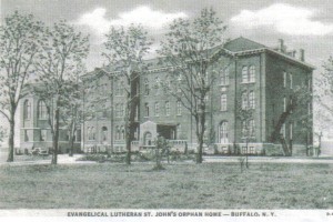
Postcard Showing St. John’s Home

The bathing house from the resort became the  home for boys as part of St. John’s Evangelical Lutheran Orphan Home in 1874.  The church and the original orphanage was located on Hickory Street.  The home for girls stayed on Hickory Street while the boys moved out to the Springs.  The boys home was destroyed by fire in 1876 and a new building was erected.   In 1898, a new building was added to the Sulphur Springs property to transfer the girls from their original home in the city and consolidate the home to one site.

The orphanage was run by the church.  The children usually remained at the Home until the age of sixteen, when they were placed out into the families of the congregation.  The grounds were 105 acres, included a hospital and schoolhouse with a gymnasium.  The students had tennis courts, a baseball diamond, a two-run toboggan slide, an orchard, and a picnic grove with shelters and grills.  In 1956, a swimming pool was added to the grounds.  To help raise money for the pool, donations were collected at neighborhood taverns.

Operating costs rose steadily for the Home following WWII as state regulations became more stringent.  The Home suffered a fire on November 14, 1959.  The increased budget due to regulations and the fire damage forced the Home to close its doors in 1960.

st johns dining hall

St. John’s Dining Hall at LCLC

Although the Home was closed, the Board was still allowed to donate money to those in need.  In 1965, $50,000 was given to Lake Chautauqua Lutheran Camp for the construction of St. John’s Hall.  The Gustavus Adolphus Home for Children in Jamestown was also given a $275,000 grant in 1967.

A portion of the property actually still provides for youth, as it is now the location of the Renaissance House, a drug and alcohol rehabilitation facility for adolescents.

In 1891, the Buffalo Parks Commissioners had considered using a grove of trees near Mineral Springs as a location for a park.   A report was made describing several places as potential for parks in South Buffalo.  The grove at Mineral Springs was described as “wet, except in the driest months of the year”, and the grove had been known informally as “Old Red Jacket Park” and was used as a picnic resort.    The park was rejected for this location and the Cazenovia Park site was chosen as the site to build the new park.  This grove of trees was referred to as “Old Red Jacket Park” until at least the 1920s.  This grove of trees still exists along the north side of Mineral Springs Road.

So the next time you use some bath salts, be sure to think of the mineral springs in Buffalo!  Be sure to read up on other streets in the street index.

Sources:

  1. “Street Names Link South Buffalo to Its Indian Past” Buffalo Evening News 9-14-1960
  2. “The Indian Reservation Sulphur Springs, Near Buffalo NY with an Account of its Analysis, Medicinal Properties, and the Diseases for Which it is Applicable”.  A.F. Lee, Printer:  1848.
  3. http://buffalo-orphanage-studies.com/StJohns.html
  4. Thirteenth Annual Report of the Buffalo Park Commissioners, Buffalo:  Press of the Courier Company,  January 19, 1883.
  5.  Verlag and Druck Van Reinecke & Zesch, History of Germans In Buffalo and Erie County: Buffalo, 1898.  Part I, pgs 282-286.
  6. Alexander, W.P. “What Spring Means to the Lover of Flowers”, Hobbies Magazine,  Buffalo Society of Natural Sciences, May 1920.
Advertisement

Read Full Post »

joseph ellicottThis is the third and final part in a series about Joseph Ellicott.  Click here to read Part One about Joseph’s family and his early life.  Click here to read Part Two, about Joseph’s days with the  Holland Land Company.  Today, I am going to touch on Joseph’s legacy throughout Western New York.

Mindful of Buffalo’s strategic location as a port, Joseph Ellicott was a strong advocate for a canal to be built from the Hudson River to Lake Erie. He served as one of the first Erie Canal Commissioners and was appointed in 1816 to supervise the canal construction.  He was also responsible for convincing Governor Clinton not to send to England for engineers to design the canal, but to use local talent instead.  He donated more than 100,000 acres of company land for the canal project.  He resigned from the Canal in 1818, due to his declining health.

Joseph worked hard to further the settlement of Buffalo by encouraging development on certain transects.   As hard as Joseph worked, his later years were not as bright.  He suffered from physical and mental health issues in his later days.  As early as 1816 he began to suffer from periods of depression and melancholy.  At the time, his condition was thought to have been brought upon by his lonely, unmarried life as well as the disappointments of the unrealized hopes and dreams.  In 1821, the Holland Land Company suggested that he was no longer needed and  Joseph retired.   He became a hypochondriac and was admitted to Bloomingdale Asylum in New York City by his family around 1824.  He died in 1826 by hanging himself.  He was originally buried in New York City, but was exhumed and reburied in Batavia in the Batavia Cemetery.

Joseph Ellicott's Gravestone

Joseph Ellicott’s Gravestone

Joseph’s grave was erected in 1849 by his sister Rachel Evans. and is engraved with the following:

“He was the first resident agent of the Holland Land Company for whom in 1798 he began the survey of the western part of the state then owned by them.  Even at that day his predictions of its future wealth and importance fell but little short what has since been realized.  For more than twenty years, he used with great judgement combined with liberality, the powers entrusted to him as one of the earliest and by far the most efficient advocate of the Erie Canal.  His name is a part of the history of New York.  His reputation among his fellow citizens as a man of the highest intelligence as well as the influence of his station gave his opinions great weight with every successive administration during the first twenty years of the present century, and in every portion of the tract once subject to his control may be seen marks of his foresight and generosity.  He was the founder of Batavia and Buffalo, NY.”

The following places were named after Joseph Ellicott:

  • Ellicottville, New York – a village in Cattaraugus County
  • Ellicott, New York – town in Chautauqua County
  • Ellicott Square Building – A ten story office building in Downtown Buffalo.  When it was built in 1896, it was the largest office building in the world.  The building was designed by Charles Atwood of Daniel Burnham & Company Architects.  The building sits on the lot that Joseph Ellicott originally owned.
  • Ellicott Street – in addition to the one in Buffalo, there’s an Ellicott Street in Batavia, and an Ellicott Road in Orchard Park
  • Ellicott Complex – dorms at University of Buffalo
  • Ellicott Creek – a creek that runs through Tonawanda and Amherst
  • Ellicott Elementary School  -in orchard park
  • Ellicott Run – in Sinnemahoning State Park in Pennsylvania
Joseph Ellicott's Plan for the Village of New Amsterdam

Joseph Ellicott’s Plan for the Village of New Amsterdam

If you look closely at Joseph’s plan from 1804 (click on the picture for a better view), you will notice that some of the streets have different names.  Joseph named the streets after the dutch investors and  members of the Holland Land Company.

The street changes occurred on July 13, 1825.  There was a battle between the Highway Commissioners of the City of Buffalo and Joseph Ellicott.   As discussed in Part Two, Joseph owned a large lot in Downtown Buffalo.  After the Highway Commissioners decided that Main Street needed to be re-routed to cut through his property, Joseph changed his will to avoid leaving the land for a park.  In order to spite Joseph, the Commissioners changed the names of the streets:

  • Willink Avenue and Van Straphorst Avenue became Main Street
  • Schimmelpennick Avenue was renamed Niagara Street
  • Stadnitski Avenue was named Church Street since it was the location of St. Paul’s Church
  • Vallenhoven Street was named Erie Street
  • Cazenovia Street became Court Street, because the Courthouse was located near where the Central Library is currently located
  • North and South Onondaga Streets were merged to become Washington Street
  • North and South Cayuga Street became Pearl Street
  • Franklin was renamed from Tuscarora Street
  • Busti Avenue became Genesee Street
  • Mississauga Street became Morgan Street (which is currently South Elmwood)

In March 1836, Crow Street became Exchange Street.  In the end, Seneca, Swan, Chippewa, Huron, Eagle and Delaware were the only street names given by Joseph Ellicott that remained.

The Highway Commissioners must have felt a twinge of regret, because the changed the name of Oneida Street to Ellicott Street, honoring the man who laid out our streets and helped the fledgling Village of Buffalo Creek become the City of Buffalo.

To learn about how other streets got their name, check out the Street Index.  If you want to be the first to know about new blog posts, subscribe to the blog and updates will be emailed to you.  And as always, if you have any questions about specific streets, leave them in the comments and I can see what I can do to add them to my queue.

Sources:
  1. “Joseph Ellicott”  Memorial and Family History of Erie County New York. Volume 1, Biographical and Genealogical
  2. Beers, F.W.  ”Our County and It’s People:  A Descriptive Work on Genesee County, New York.”  J.W. Vose & Co Publishers, Syracuse NY 1890.
  3. “Our Street Names:  They Tell Much of Buffalo’s History”.  Buffalo Express, November 14, 1897.
  4. Burns, Rosamond.  ”Paving the Way For Settlers:  The Rise and Fall of the Holland Land Co.”  Buffalo News, January 25, 2004.
  5. Houghton, Frederick.  ”History of the Buffalo Creek Reservation”.   Buffalo Historical Society Publications, Volume 24:  Buffalo, 1920.

Read Full Post »

Holland Land Purchase

Holland Land Purchase

This is Part Two of a series on Joseph Ellicott, for whom Ellicott Street is named.  If you haven’t read Part 1 yet, you can read it by clicking here.

Following his time surveying in Washington, DC and along the Georgia-Carolina boundary, Joseph Ellicott began to survey some property in Western PA that a group of Dutch investors purchased.  The Dutch Investors had formed the Holland Land Company to invest in land in New York and Pennsylvania.  The Company also purchased a large tract of land in Western New York known as the Holland Purchase.  The Holland Land Purchase consisted of approximately 3,250,000 acres of land, stretching from 12 miles west of the Genesee River to the present western boundary of New York State.  Much of the land had been owned by Robert Morris, who had purchased it from the Senecas.  Between 1798 and 1800, the area was surveyed under the direction of Joseph Ellicott.  Joseph brought a crew of 11 surveyors, each with his own assistants to survey the property.  Joseph himself surveyed the east line of the purchase.   While Joseph laid out the site of Buffalo, there were many who doubted a city would establish there. Interference from the State and Buffalo Creek Reservations was calmed due to Joseph’s skills as a surveyor and diplomat.  He persuaded the Senecas to leave the Village’s location out of the reservation.  At the time, the Buffalo River as we know it was only a simple stream that ended in a marshland.  Joseph foresaw that Buffalo would be important as a port due to the convergence of Buffalo Creek on Lake Erie.  In Spring 1798, Joseph opened the first wagon track in Erie County, improving the trails from East Transit to Buffalo, and from Buffalo to Batavia.

The Holland Land Company had purchased the land, intending to sell large tracts of lands to investors for a profit. The bankers were unable to sell large tracts of land and began to sell directly to settlers looking to build homes.   Holland Land Company bought the land for 35 cents per acre and sold it for $2-2.50 per acre.

Holland Land Office in Batavia (now a museum)

Holland Land Office in Batavia (now a museum)

Joseph Ellicott was appointed Resident Agent of the Holland Land Company and opened an office in Batavia in 1801.    He oversaw the surveying crews to complete the subdividing the land into townships , each six square miles.  The townships were then subdivided into lots.  The officers of the Holland Land Company had an extensive program to build roads, lay out towns and attract settlers to the area by selling small tracts of land on liberal terms and providing loans to help businessmen set up shops.  The typical agreement was a down payment of  5-25 percent to be paid in 4-8 years at 7 percent interest.  During that period, the settlers were required to clear several acres of land, erect a dwelling and fence in a portion of his property.   Pioneers purchasing land here faced the hard task of relocating.  It took weeks or months to navigate over muddy, rugged roads.   The area was primarily a primeval forest.   A typical settler would have to clear about 50 trees to build a modest log cabin.

The first map of Buffalo was made by Joseph in 1804, calling it the Village of New Amsterdam, to honor the Holland Land Company.   The fledgling Village had a population of about 25 at the time, including a blacksmith, a silversmith, and half a dozen houses.  While Ellicott wanted to call it “New Amsterdam”, the residents preferred the name of Buffalo Creek, so their name stuck, which was then later shortened to Buffalo.  He is responsible for the radial street plan of the City of Buffalo.  He named most of the streets after members of the Holland Land Company.

Buffalo Lots in 1805

Buffalo Lots in 1805
(Lot 104 can be seen in the center of the map)

Joseph Ellicott also purchased his own share of Downtown Buffalo, a 100-acre tract of land known as Outer Lot 104, bounded by the current Main Street, Swan Street, Eagle Street and Jefferson Avenue.  There was a half-moon shaped piece of land along the Main Street frontage of Joseph’s property, from which Niagara, Church and Erie Streets radiated.  Joseph planned to build a mansion on this half-moon; however, in 1809, the Village authorities decided to straighten Main Street.  Ellicott abandoned the idea of building on the lot and during his lifetime, no development occurred on Outer Lot 104.   Also, Ellicott changed his will, which had been drawn to leave the tract of land to the City for a public park.   Today, the Ellicott Square Building sits on the Main Street part of the lot, a fitting reminder of Ellicott’s influence in Buffalo.

Many of the settlers were unable to pay back for their land; however, Joseph was lenient with them and allowed them to extend their payments.   After 10 years, the Holland Land Company opened an office in Mayville in Chautauqua County. This allowed them to better serve the pioneers by ridding them of the burden of travelling all the way to Batavia to make payments.

During the War of 1812, the Holland Land Company allowed settlers to make payments in goods instead of cash.  They mostly accepted black salt, which they would then make into pearl ash to sell to Montreal.

In 1833, New York State laws changed, forcing foreign owners to be taxed the same as residents.  The Holland Land Company began to enforce their payment schedules and were no longer as lenient with settlers.

Holland Land Company Vault postcard, Mayville NY

Holland Land Company Vault postcard, Mayville

In 1835, the Holland Land Company sold its remaining holdings in Chautauqua County to Trumbell Cary, George Lay, Jacob LeRoy and Herman Redfield.  They instituted a new policy called the “Genesee Tariff”, forcing those who still owed to pay a penalty of a specific amount per acre in additional to the original price paid for the land.  They also threatened to sell the land to another purchaser if payments were not made.  The settlers fought back against the Genesee Tariff.  In 1836, 500 men gathered in Hartfield, rioted and marched to Mayville to destroy the Land Office.  The building and furniture were destroyed and the company’s books were burned in a bonfire.  The company salvaged what they could and reopened an office in Westfield.   William Seward was made the Land Agent of the new office, and was able to renew peace.  Seward later went on to become Abraham Lincoln’s Secretary of State, and is best known for “Seward’s Folly”, aka the purchase of Alaska.  A stone vault near the present day County Courthouse is the only visible landmark of the Holland Land Company’s presence in Chautauqua County.

In 1839, the Holland Land Office in Batavia closed.  The last holdings of the company were sold in 1846 at little profit.  The building, which was built in 1815 to replace the original log cabins is still standing in Batavia.   The building is listed on the National Register of Historic Places.  The building was saved by a Batavia High School teacher, John Kennedy, and the Class of 1894.  The site currently operates as the Holland Land Office Museum.

For more on Ellicott’s legacy in Western New York, check out Part Three by clicking here.

Sources:

  1. “Joseph Ellicott”  Memorial and Family History of Erie County New York. Volume 1, Biographical and Genealogical
  2. Beers, F.W.  “Our County and It’s People:  A Descriptive Work on Genesee County, New York.”  J.W. Vose & Co Publishers, Syracuse NY 1890.
  3. “Our Street Names:  They Tell Much of Buffalo’s History”.  Buffalo Express, November 14, 1897.
  4. Burns, Rosamond.  “Paving the Way For Settlers:  The Rise and Fall of the Holland Land Co.”  Buffalo News, January 25, 2004.
  5. Houghton, Frederick.  “History of the Buffalo Creek Reservation”.   Buffalo Historical Society Publications, Volume 24:  Buffalo, 1920.

Read Full Post »

Granger Place is a short road in the Elmwood Village, running less than 1/4th of a mile, between Elmwood Avenue and Lincoln Parkway between Forest Avenue and Bird Avenue.  The street was originally known as Elmhurst.   The street is named for Erastus Granger, one of Buffalo’s earliest residents and the Village’s first postmaster.

Erastus Granger was a businessman raised in Connecticut.  He was sent by a group of New England businessmen to look after their investments in Virginia and Kentucky.  While in the south, he met and befriended Thomas Jefferson.  He worked on Jefferson’s campaign for President, and when Jefferson took office, he sent Erastus Granger to Buffalo and appointed him postmaster of the Village in 1803.  When Mr. Granger arrived in Buffalo Creek (which is what Buffalo was called at the time), there were only 16 huts, three blacksmith shops, a taverns, a drugstore and a jail.   He sent up his post office in a desk at Crow’s Tavern on Exchange Street.  You can visit Mr. Granger’s desk and see a replica of Crow’s Tavern in the Pioneer Gallery at the Buffalo and Erie County Historical Society!

Mr. Granger built a house near where the Main Street entrance of Forest Lawn cemetary is today.  His farm extended north to West Oakwood and west to Elmwood Avenue.   Granger Place is located on a small portion of his 800-acre estate, which he called Flint Hill, due to the rock in the soil.  His estate included all of the lands now containing Forest Lawn, Delaware Park, Buffalo State College and the Richardson Complex!    He built the Buffalo Harbor lighthouse in 1817, which was replaced in 1830s by the current Buffalo lighthouse.

During the War of 1812, Mr. Granger worked with Red Jacket and other indian leaders to get them to sign a treaty of neutrality.  The Native Americans kept the treaty until the Indians from Canada invaded their territory, at which time they joined the Americans.    Mr. Granger opened his property as a safe haven for refugees of Buffalo after the British burned the Village.

During the Winter of 1812-1813, The Army of the Frontier under General Alexander Smythe set up camp at Flint Hill in anticipation of invading Canada.  Nearly three hundred soldiers died there.  The dead were buried in Granger’s meadow, in the present Delaware Park.    A plaque at Main Street and Humboldt Parkway, and a stone in the Delaware Park meadow memorialize the Flint Hill Encampment and the 300 soldiers buried there.

Erastus Granger’s grave is located on land that he once owned in Forest Lawn cemetary.   Red Jacket delivered the Eulogy at his funeral.

Sources:

“Granger Place Honors Memory of First Buffalo Postmaster” Courier Express Sept 18, 1938, sec 6 p 10

Read Full Post »

Hidden Waters blog

Companion blog for the book "Hidden Waters of NYC"

DenCity

Urban History Blog

Hoping for a Tail Wind

Because I definitely brought way too much gear.

priorhouse blog

Photos, art, and a little bit of LIT.

Sheepie Niagara

The most popular sheep in Niagara Falls

Nonprofit AF

Exploring the fun and frustrations of nonprofit work

Gather by Image

An anagram. And a reason to write... to Grieve... to Heal