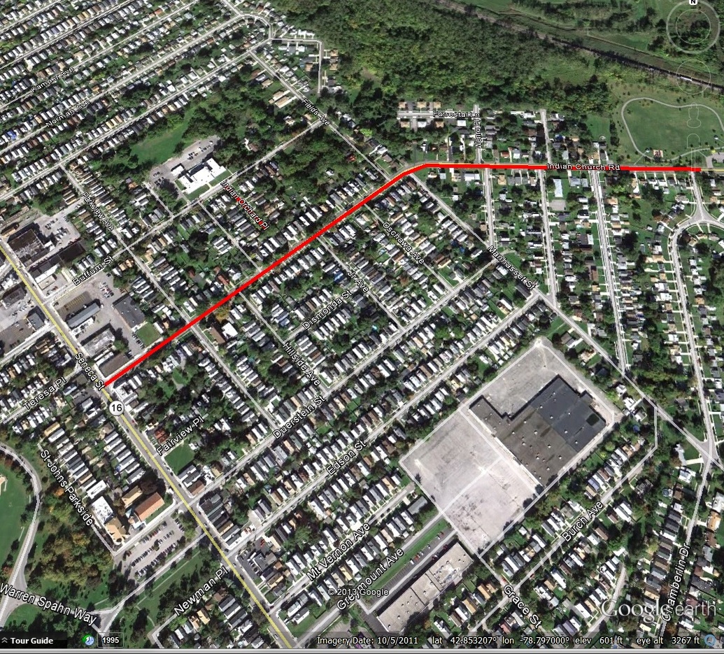
Spaulding Street, shown in red on the map
Spaulding Street runs for two blocks between Hopkins Street and South Park (formerly Triangle Street in the Triangle Neighborhood of South Buffalo. The street opened in 1890 and is named after Elbridge Spaulding.
Elbridge Gerry Spaulding was born in Summer Hill, Cayuga County, on February 24, 1809. His ancestors arrived in Massachusetts in 1630 and many of them fought in the Battle of Bunker Hill. Mr. Spaulding attended the common schools in his area. When he was 20, Elbridge began his study of law in the office of Timothy Fitch in Batavia. He completed his studies in Attica, at the offices of Harvey Putnam.
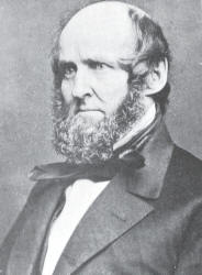
Elbridge Gerry Spaulding
Mr. Spaulding moved to Buffalo 1834 to practice law in the office of Potter and Babcock, the leading attorneys in Buffalo at the time. He became a partner in Potter and Babcock. Just two years after arriving in Buffalo, Mr. Spaulding was appointed City Clerk in March 1836. Also in 1836, he was admitted to practice as an attorney of the Supreme Court and in 1939 as a counselor of the Supreme Court and the Court of Chancery.
In the 1840s, Mr. Spaulding was law partners with John Ganson. Mr. Spaulding’s law practice was large. In 1841, Mr. Spaulding was elected as Alderman of the Third Ward and became Chairman of the Finance Committee.

Spaulding Exchange Building. Source: Buffalo Express
Around 1845, Mr. Spaulding acquired what became the Spaulding Exchange, which was a five-story building with many shops and stores on the first floor and offices on the upper floors. The Exchange was located at the corner of Lower Terrace and Main Street and became the hub of Buffalo’s financial industry. It quickly became one of the most important office buildings in the City and was home to lawyers, bankers, insurance agents and real estate dealers of the time. Mr. Spaulding’s office was located in the building, as well as the Farmers & Merchants Bank and the Bank of Attica (two banks which Mr. Spaulding was involved with). The building was destroyed by fire in 1851 and reconstructed shortly afterwards. The building was remodeled again by the Spaulding Heirs in 1917. The Spaulding Exchange building was still owned by the family when it was was demolished for construction of Memorial Auditorium in 1938, after standing for nearly 100 years!

Elbridge Spaulding. Source: History of the City of Buffalo and Erie County.
In 1847, Mr. Spaulding was chosen as Mayor of the City of Buffalo by the Whig party. While he only served a year, his administration was considered one of progress and achievement. While he was Mayor, State Aid was obtained to enlarge the Erie and Ohio Basins to improve facilities for lake and canal commerce in Buffalo. He also oversaw the construction of an extensive sewage system. The Buffalo Gas Light Company was also organized while he was Mayor, bringing light to the city’s streets and houses.
Mr. Spaulding was elected to the New York State Assembly in 1848. While there, he was Chairman of the Canal Committee. He also served on the Canal Board, helping to secure a $9 Million loan on State Credit to enlarge the Erie and Oswego Canals.
Mr. Spaulding was elected to Congress in 1849, as a Whig candidate. He was a member of the Foreign Relations Committee. He also worked with factions of both the Whig and Democratic parties to oppose slavery. Particularly, fighting against extending slavery into the new states of California and New Mexico, which was an issue at the time. He supported President Taylor’s policy to admit California as a free state and opposed the Omnibus Bill which is better known as the Compromise of 1850.
In 1853, Mr. Spaulding was elected Treasurer of New York State. He was the founder and President of Farmers & Mechanics National Bank in Buffalo from 1852 until his death.
Mr. Spaulding was elected back into Congress in 1859, this time as a Republican. In 1860, he gave speeches in Buffalo and Washington at meetings held to ratify the nomination of Abraham Lincoln. The speech denounced the Democratic Party and it’s pro-slavery views. He said:
“A change is essential to the stability of the Constitution and the Union. We must unitedly resist the Democratic party, and redeem the country from thraldom into which it has been placed by corrupt leaders. Why should we thus unite? I answer, because the perilous condition in which the country is placed demands it. Who is responsible for the agitation of the slavery question? Who obstruct the public business by agitation? Who threaten disunion? Who are sectional in their speeches and action? and who seek to extend the area of slavery and slave representation in Congress?”
He urged Republicans to support Abraham Lincoln for the US Presidency.
During the Civil War, the U.S. Government had to be loaned money to finance the war. The Banks of New York, Philadelphia and Boston had loaned the US Government $150 Million in gold. Their resources were so depleted that there was a danger of national bankruptcy and panic. Mr. Spaulding was the Chair of the Ways and Means Committee in the House of Representatives. The committee was instrumental in formulating the most important legislation authorizing war loans. In December 1861, Mr. Spaulding presented Congress with a speech proposing the currency bank bill, later known as the Legal Tender Act and teh National Currency Bank Bill. These bills allowed treasury fundable notes to be circulated as money as a war measure. It also expanded the nation’s credit and bolstered confidence in the American dollar. These acts are what makes paper bills legal tender, and why American money says “This note is legal tender for all debts, public and private”. The issuance of our paper money is still based on the Legal Tender Act, as presented by Mr. Spaulding. Because of his finance experience and knowledge, his proposal for the Greenback won respect from his fellow members of Congress. For this reason, he is often referred to as the Father of the Greenback.
Elbridge Spaulding was married three times. First to Jane Antoinette Rich in 1837. Jane was the daughter of G. B. Rich, proprietor of the Bank of Attica. Mr. Spaulding encouraged the bank to move to Buffalo and became an officer of the bank. Jane died in 1841 at just 22 years old. They had no children. Elbridge married Nancy Strong in 1842. Nancy was considered to be one of the most beautiful girls in Buffalo. Nancy and Elbridge had three children – Charlotte, Edward Rich, and Samuel Strong. Nancy died in 1852. After her death, he married Nancy’s sister Delia. Elbridge and Delia bonded over their grief of the loss of Nancy as well as Delia’s grief over becoming recently widowed herself and was also mourning the loss of her 16 year old daughter Mary who died in 1847. Delia and Elbridge were married 40 years.
 In 1850, the Spaulding Family moved into a in a mansion at 775 Main Street, at the corner of Goodell. The house was originally built for William Hollister in the 1830s. The house was built on what had been the site of Jabez Goodell’s Broadwheel Tavern.
In 1860, The Spauldings lived with Patrick Cunnington, a 25-year-old Irish man who served as coachman; and servants John Myer, a 17 year old boy from Prussia; Ellen Match, a 22-year old woman from New York; Catherine Ott, a 22 year old woman from Bavaria; and Caroline Riehl, a 17 year old girl from New York.
In 1870, the Spauldings lived with seamstress Sarah McConkey, a 30-year-old woman from Canada; and Domestic servants Mary Kraemer, a 26-year-old woman from Mecklenburg-Schwerin; Johanna Roth, a 36-year-old woman from Ireland; and Peter Duringer, a 21-year-old man from Hesse-Darmstadt.
In 1875, the Spauldings lived with “jack of all trades” Peter Dearing, a 26 year old man from German; Rachel Bradley, a 25- year old cook from Ireland; Katie Cofield, a 25 year old “dining room girl” from Prussia; and Mary Flynn, a 25-year -old seamstress from England.
In 1880, the Spauldings lived with cook Rachel Bradley, a 29-year-old woman from Ireland; Marianne Cofield, a 23-year-old servant from Ireland; and seamstress Caroline Schroeder, a 27-year-old woman from Bavaria.

River Lawn, the Spaulding Estate on Grand Island. No longer standing. Source: Lost Grand Island
The Spauldings also built a summer home, called River Lawn, on Grand Island around 1870. At this time, Grand Island became an ideal recreational place for many of Buffalo’s wealthy families. They would arrive on Grand Island by small steam boats. River Lawn was located between the Beaver Island Club, a private hunting and fishing club and Lewis Falley Allen’s estate, Falconwood. The River Lawn house was built in the Stick Style. River Lawn’s 350 acre estate overlooked the Niagara River and encompassed a half-mile of riverfront, broad woodlands and cultivate fields. The estate included a farm, where Mr. Spaulding bred Holstein-Fresian cattle. Many of the estates and resorts began to close around WWI, as a result of fires, the development of the automobile and the opening of the Canadian lakeshore resorts. Between 1925 and 1930 the State of New York began to purchase land on Grand Island. The State ended up purchasing 780 acres, including the Spaulding Estate and other estates. In 1935, Beaver Island State Park opened for public use, the same year the Grand Island bridges opened.

River Lawn Boathouse, built in 1870 by Mr. Spaulding
The boathouse from River Lawn was also built in 1870 by Mr. Spaulding. A fancy Victorian era structure, with balconies, arched windows, and French doors. When River Lawn became part of Beaver Island, the boathouse was going to be demolished. It was saved by Mr. Spaulding’s grandson, Frank St. John Sidway. Frank floated the boathouse upriver to his property. The Boathouse is not part of the state park, it is privately owned. The Boathouse was listed on the National Register of Historic Places in July 1998.
In 1875, for the centennial of the Battle of Bunker Hill, Mr. Spaulding erected a granite cenotaph in Forest Lawn Cemetery in honor of “100 Years of Progress”. Mr. Spaulding dedicated it in memory of his family members who had fought in the battle, which included Elbridge’s grandfather and 8 other family members!

Battle of Bunker Hill Monument at Forest Lawn in the Spaulding Plot
Mr. Spaulding was involved in many organizations in Buffalo. He was a life member of the Young Men’s Association (the predecessor to the Buffalo Library), a life member of the Buffalo Historical Society, a member of the Society of Natural Sciences, and a member of the Buffalo Club. He was president of the International Bridge Company and a stockholder in several local banks. He was also involved in the early Buffalo Street Railroads. He helped found the University of Buffalo in 1846 and was a member of the University Council until his death. The Spauldings were member of First Presbyterian Church.
Mrs. Delia Spaulding died on August 12, 1895. Mr. Spaulding died May 5, 1897, at 89 year old, after suffering a stroke. They are buried in Forest Lawn. The Spaulding Plot at Forest Lawn is home to more than 30 Spaulding relations. The most recent burial in the plot was Elbridge Gerry Spaulding’s great grandson in 2013! In addition to the street, Spaulding Quadrangle at University of Buffalo is named for Mr. Spaulding.

Spaulding Building on Main Street in 1908. Source: A History of Buffalo
Mr. Spaulding left behind an estate estimated to be valued at between $12 and $14 Million (approximately $430 to $502 Million in today’s dollars). Mr. Spaulding’s will stipulated that the house at 775 Main was to be demolished after his death. Daughter Charlotte and son Edward developed the site with two buildings. The Spaulding Building was built at 763 Main Street in 1906 by Edward Rich Spaulding. The Spaulding Building is a three story commercial and residential building with Classical styling. The building was designed by McCreary, Wood and Bradney. The building was purchased by Nick Sinatra in 2015 and is still residential and commercial mixed use.

Sidway Building image from 1979. Source: NYSHPO
Charlotte and her husband Franklin Sidway built the Sidway Building at 775-783 Main Street in 1907. The Sidway Building is a six-story mixed use building, also designed by McCreary, Wood and Bradney. When it opened, the Sidway Building was one of the largest buildings in this part of Main Street. It was originally built as a four-story loft style building for light manufacturing. Two stories were added in 1913. In 1927, the building was remodeled into a modern office building. In the early 2000s, the building was converted into 67 apartments on the upper floors.

Spaulding-Sidway House at River Lawn on Grand Island. No Longer Standing. Source: Lost Grand Island.
After Mr. Spaulding’s death, River Lawn was inherited by daughter Charlotte. Charlotte and Franklin built a grand Georgian style home on the Estate. The house was destroyed when it became a part of Beaver Island State Park.
Mr. Spaulding’s grandsons Steven Van Rensselaer Spaulding and Elbridge G Spaulding II were successful in the coal industry in the early 1900s. Their company, Spaulding & Spaulding, merged with the Hedstrom Company to become the Hedstrom -Spaulding Company.

Restored Spaulding Portrait. Source: Buffalo News.
In the 1990s, Mr. Spaulding’s portrait from 1876 was found languishing in a closet in City Hall. The portrait was restored by Buffalo State College’s Art Conservation Department. The restoration of the portrait took a year. Spaulding’s portrait was the first to be restored in partnership between Buff State and the Buffalo Art’s Commission, who oversees public art in the City of Buffalo. Several Spaulding descendants were in attendance when the restored portrait was unveiled in Mayor Masiello’s office in 1996.
Want to learn about other streets? Check out the Street Index. Don’t forget to subscribe to the page to be notified when new posts are made. You can do so by entering your email address in the box on the upper right-hand side of the home page. You can also follow the blog on facebook. If you enjoy the blog, please be sure to share it with your friends. As I post this, we are currently in the midst of the Blizzard of 2022 – I hope you all are staying safe and warm. I hope you all have a lovely holiday weekend and a happy and healthy New Year!
Sources:
- Smith, H. Katherine. “Spaulding Avenue Named for Father of Greenback”. Buffalo Courier-Express. October 23, 1938, p12.
- Vogel, Charity. “1870s boathouse ‘jewel’ is placed on historic registry”. Buffalo News. July 22, 1998, p2.
- Lost Grand Island. isledegrande.com/preservation.htm (accessed December 2022).
- Buckham, Tom. “Former Mayor Basks in Restoration to Office.” Buffalo News. December 17, 1996, p12.
- Spaulding, E. G. “The Republican Platform”. Speech delivered at Buffalo and Washington, at meetings held to ratify the nomination of Abraham Lincoln and Hannibal Hamlin. 1860. Found online here: https://archive.org/details/republicanplatfo00spau (accessed December 2022).
- “Spaulding Funeral” Buffalo News. May 6, 1897, p17.
- “The Late E. G. Spaulding. Buffalo Morning Express. May 9, 1897, p3.
- “Old Buffalo Landmark to be Improved.” Buffalo News. August 18, 1917, p13.
- “Convention Hall to be Monument to City’s Past”. Buffalo News. February 18, 1939, p16.
- “A History of Buffalo It’s Men and Institutions”. Buffalo News. 1908.
 Abbott Road is a road that starts in the City of Buffalo at an intersection of Bailey Avenue and South Park Avenue and runs to an intersection at Bayview Road/Armor Duells. Abbott Road is about 9 miles in length and runs through not only the City of Buffalo, but also the City of Lackawanna and the Town of Orchard Park. Abbott Road used to continue north across the Buffalo River towards the First Ward neighborhood, but that portion of the road was changed to
 Seth Abbott died on June 8, 1831 and is buried in Hillcrest Cemetery in Hamburg.
 Samuel Abbott died on October 2, 1846 and is buried in Deuel Cemetery in Orchard Park.
 Kimmel Avenue is a short street, running two blocks between Abbott Road and Cazenovia Creek in South Buffalo. The street is named after Christian Kimmel, an inventor.
 Mr. Kimmel owned much of the real estate on the street that now bears his name. In addition to real estate and politics, he enjoyed working in his yard and garden and was proud of his horses, which he’d drive around town on their carriage.