Feeds:
Posts
Comments

Posts Tagged ‘South Buffalo’

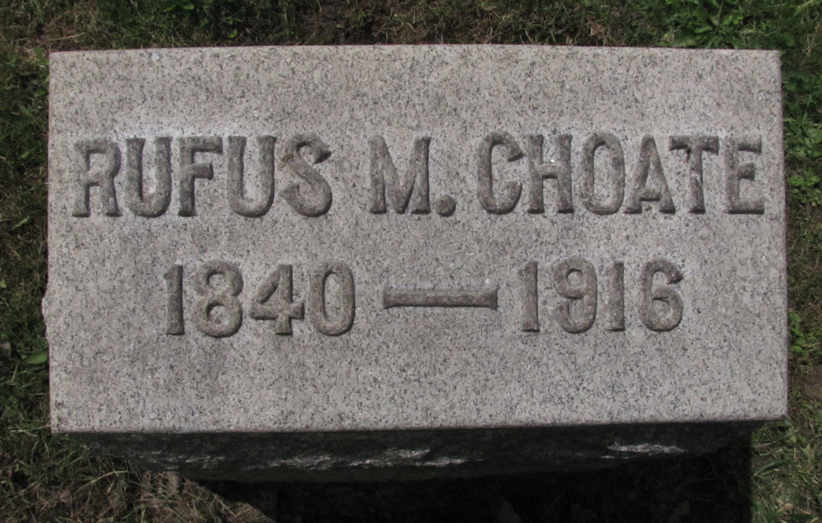
McKinley Parkway is one of the Frederick Law Olmsted designed parkways.  The parkway system Olmsted designed allows the greenspace of the park system to radiate out into the neighborhoods.  McKinley Parkway runs from the main entrance of South Park past McKinley and McClellan Circles to Heacock Place.  During the 1890s, much of the land for the parkway was donated by residents of South Buffalo who wanted to have the benefit of having a parkway in front of their homes.  McKinley Parkway was often referred to as the Delaware Avenue of South Buffalo, as it was a street of stately homes occupied by prominent Buffalonians.  During the 1930s, a portion of McKinley was extended north across Abbott Road to connect to Bailey Avenue.  The parkway was originally known as South Side Parkway.  The name was changed in December 1915, to honor McKinley.  South Side Parkway’s name was selected as the street name to change because many residents about their mail delivery – residents living on South Park and South Side Parkway often got each others mail.  At this time, they also changed the name of Woodside Circle to McClellan circle, for a similar reason.  The traffic circle at McKinley and Dorrance Avenue is known as McKinley Circle, but was also originally known as South Side Circle.   When South Park Avenue was created from various South Buffalo Streets in 1939, they renamed a portion of the former South Park Avenue, reusing the Southside Parkway name.

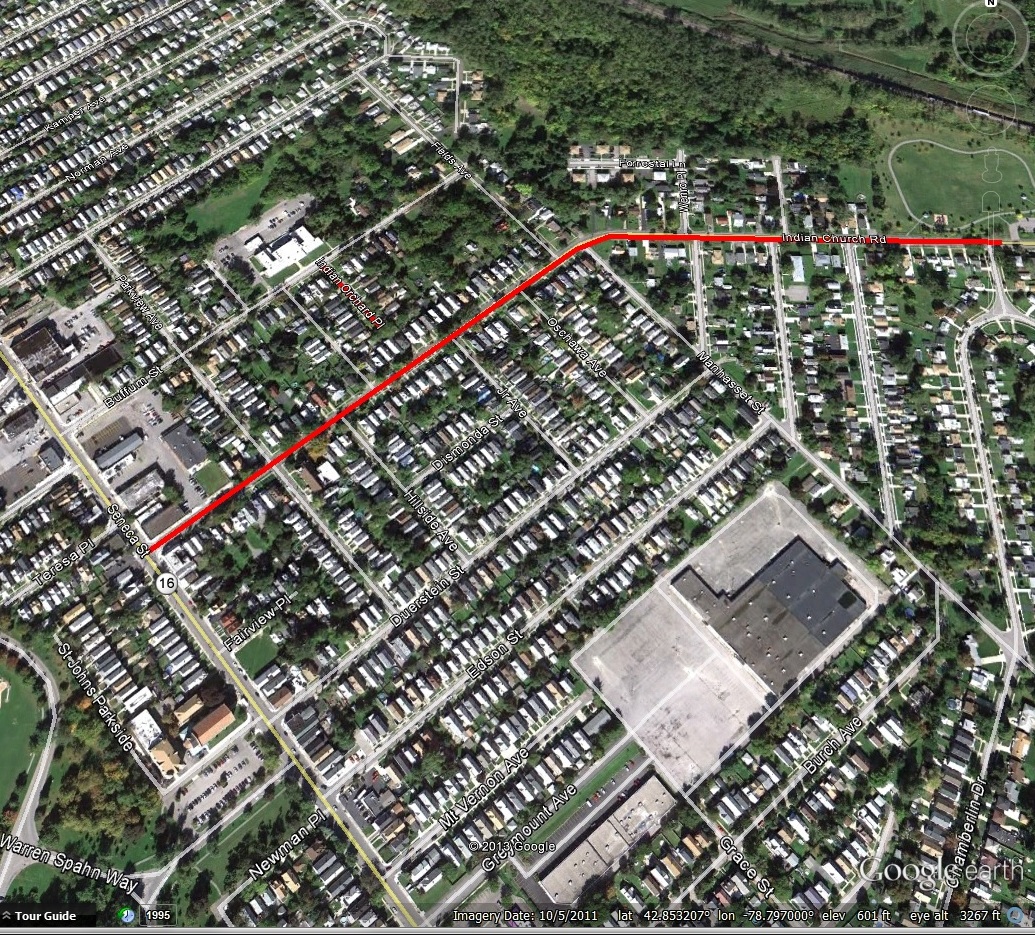
Heacock Place – the start of the South Buffalo Olmsted Parks and Parks system and where McKinley Parkway originates

The South Buffalo Olmsted parks and parkways system was listed on the National Register of Historic Places in 1982.  The system consists of the following:  Heacock Place, McKinley Parkway, McClellan Circle (formerly Woodside Circle), Red Jacket Parkway, Cazenovia Park, McKinley Circle and South Park.  The South Park-Cazenovia Parks and Parkways were created later than the Delaware Park-Front Park-Humboldt Park system.  Fillmore Parkway was originally designated to be a link between Humboldt Park (now Martin Luther King Jr Park) to South Park.  Olmsted originally proposed the plans for South Park in 1887.  South Park was built on a smaller scale than originally planned, as by 1893 when the park was approved by Common Council, industrial development had begun to take over the lakefront area originally designated for the park.  Planning for Cazenovia Park coincided with the development of South Park, and Olmsted planned for the South  Side Parkways to link the two parks.  Fillmore Avenue was partially laid out, but the full vision was never completed to connect the southern parks with the older parkway system in the northern part of town.

President McKinley on Cayuga Island, 1897.
Source: Niagara Gazette, March 26 1931, pg 8

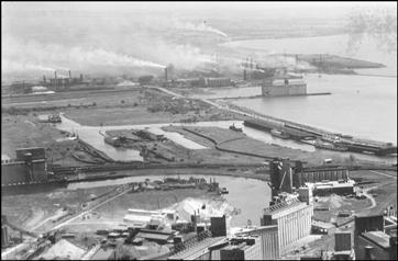
President McKinley enjoyed world’s fairs, and referred to them as “the timekeepers of progress” and said that “they record the world’s advancement”.  He attended the Colombian Exposition in Chicago in 1893 and the Cotton States Exposition in Atlanta in 1895.  He was involved in the Pan American Exposition as well.  He came to Western New York to celebrate the choice of Cayuga Island in Niagara Falls as an exposition location in 1897.  This fair was to happen in 1899 but was pushed back by a few years due to the Spanish-American War.  After a selection committee examined a slate of 20 different potential fair locations,  the Pan American Exposition committee selected Mr. Rumsey’s land in North Buffalo.

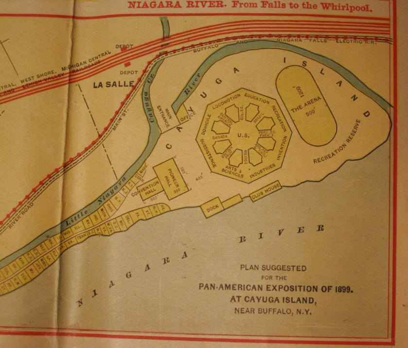
The original Cayuga Island plan for the Pan American Exposition of 1898

The McKinleys had hoped to be in town for the Pan American’s opening day in May of 1901, but Mrs. McKinley fell ill.  The President sent Vice President Theodore Roosevelt in his place.  Vice President Roosevelt talked to the President about how impressed he was with fair and particularly the electric tower, increasing President McKinley’s desire to come to see it for himself.  On September 4th, the McKinleys made it to Buffalo.  The following is a link to Thomas Edison footage of McKinley’s speech at the Exposition.

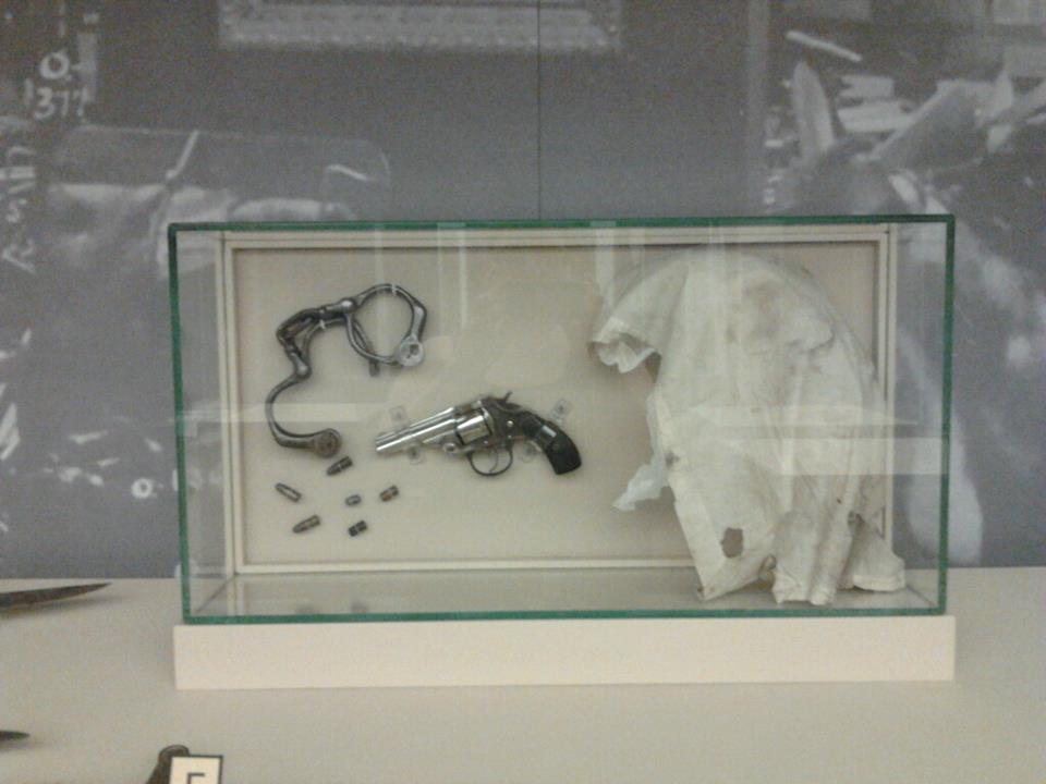
The gun that shot McKinley, in the collection of the Buffalo History Museum

The rest, as they say, is history.  On September 6, 1901, at the Pan-American Exposition in Buffalo, New York, anarchist Leon Czolgosz shot President William McKinley.  President McKinley held on for a few days, but died on the 14th.  Vice President Teddy Roosevelt was inaugurated as President at the Wilcox Mansion on Delaware Avenue here in Buffalo.  Following the closure of the Pan American Exposition, the fair was torn down and the land was subdivided for residential development.  The location where McKinley was shot is marked by a boulder with a plaque on it on one of these residential streets.

Front page of the Buffalo Courier following McKinley’s shooting.
From the Collection of the Newseum in Washington, DC

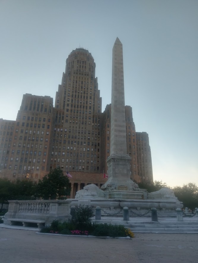
McKinley Monument in Niagara Square

The McKinley monument in Niagara Square was dedicated in 1907.  Daniel Burnham was called in to Buffalo to consult about the design of the monument.  The monument was designed by Carrere and Hastings, who also designed the Pan American Exposition and had worked with Daniel Burnham on the Chicago Exposition in 1893.   The sleeping lion and turtles sculptures were designed by A. Phimister Proctor.  The lions represent strength and the turtles represent eternal life.

The McKinley Monument was restored this summer, the monument’s first full restoration in 110 years.  The work was coordinated by the City of Buffalo, Buffalo Arts Commission and Flynn Battaglia Architects.  The monument should be completed on September 6, 2017, the 116th anniversary of McKinley’s shooting.

Want to learn about other streets?  Check out the street index here.


Sources:

  1. “Change Street Names to Avoid Confusion”.  Buffalo Courier.  December 19, 1915, pg. 82.
  2. Goldman, Mark.  City on the Edge.  Amherst:  Prometheus Books.  2007.
  3. Kowski, Francis, et.a.  Cambridge:  MIT Press, 1981.
  4. Sommer, Mark.  First Restoration of McKinley Monument in 110 Years Begins.  Buffalo News.  June 12, 2017.
  5. Williams, Deirdre.  City Hallways (August 31):  Rehab work at McKinley Monument wrapping up.  Buffalo News.  August 31, 2017.
Advertisement

Read Full Post »

aldrichAldrich Place is a short street in South Buffalo between South Park Avenue and McKinley Parkway near the Buffalo-Lackawanna border.  The street is named after a man who was one of the first settlers in that part of South Buffalo.

Alexander Aldrich came to Buffalo from England as a young man with his wife, Lucinda.  In 1855, Mr. Aldrich purchased a 50-acre farm that included the land that is now Aldrich Place.  His farm stretched from the present day South Park Avenue to McKinley Parkway, south to the railroad lines and north to Downing Street.  His farm mainly raised celery, black walnuts and flowers.  At the time, this section of South Buffalo was famous for its celery.  He built a greenhouse for the flowers on the South Park Avenue side of his property, selling to people on their way to Holy Cross Cemetery.

In those days, the Aldrich farm was located in a sparsely populated neighborhood.  Lucinda would tell stories of days when Native Americans would peer in the window.  They were curious about the light coming out of the windows and wanted to watch what a white family did at night.

During the Civil War, Alexander and Lucinda traveled to Washington, DC.  While there, Alexander had his photo taken with President Lincoln on the steps of the White House.  If any members of the Aldrich family are reading this, I’d love to see the photo if it still exists!!

Alexander and Lucinda had three sons – Henry, Wallace, and Albert – and a daughter, Sally, who became Mrs. Ace Reed.  Henry was a taxidermist.  Albert was in charge of most of the excavating and grading for the South Park Botanical Gardens.  To do this work, ten teams of horses were used; Albert hired his neighbors to assist in the work.

Alexander Aldrich's Grave

Alexander Aldrich’s Grave

Mr. Aldrich later sold his farm to the Pixley Land Company for development in 1903.  The Aldrich family house was moved to Downing Street and converted into apartments.

Alexander Aldrich died in 1897 and is buried in Woodlawn Cemetery in Orchard Park.

Alexander’s grandson, Robert Reed, was the first mayor of Lackawanna.

Check out the street index to learn about other streets!


Source:

Memorial to Farmer-florist.  Courier Express Se. 1, 1940, sec 6 p3

Read Full Post »

choateChoate Avenue is located in South Buffalo, running between South Park Avenue and Abbott Road.  The street cuts through land once owned by Rufus Choate, a man who helped build South Buffalo.

Rufus Mortimer Choate is a descendant of the Choate Brothers who were among America’s pioneer settlers from England who settled in Massachusetts in 1643.   A more famous Rufus Choate was a senator from Massachusetts.  Mr. Choate was born in Clarence on October 4, 1840.  He attended public schools, the Classical Academy in Clarence and Bryant & Stratton’s Business College.  During the Civil War, he volunteer at the first call for soldiers, enlisting in 1861, but was never called to the front.  After the War, Mr. Choate began working as a clerk in the ticket office at the Buffalo Docks and for the U.S. Customs Office.  He served as a local passenger agent for all four of the ship lines which used the Buffalo Harbor from 1866 until 1888.  In 1888, he resigned to begin working in the real estate business.

In 1866, Mr. Choate married Ellen Strickler.  Millard Fillmore’s brother performed their ceremony.  The Choate family lived at 1365 Abbott Road, their home was known as  Windermere House.  At the time, it took an entire day to travel into the city to do your shopping and then home again.  Several rail crossings were located along the route.  When they arrived at the railroad crossings, the horses would often rear up on their hind legs due to fear.  Mr. Choate worried that his wife and children would be injured if the horse would lose control.  He worked to eliminate those at grade crossings.

Windermere House was one of the first houses in South Buffalo to be lit by natural gas.  It was an English villa style home, and was surrounded by a high brick wall with iron fence and gates.  The home had nine bedrooms, a billiard room and spacious rooms for entertaining.  The grounds consisted of orchards, gardens, lawns and a tennis court.

http://digitalcollections.nypl.org/items/510d47e3-71a7-a3d9-e040-e00a18064a99

Wndermere House  Source:  http://digitalcollections.nypl.org/items/510d47e3-71a7-a3d9-e040-e00a18064a99


Windermere House became the first Mercy Hospital.  The Sisters of Mercy who were brought in 1858 by Bishop Timon to assist with schooling at St. Brigid’s.  The Sisters soon realized that a hospital was needed.  The original hospital was a 30-bed facility opened in the house in 1904.  The hospital is still located at the corner of Choate Avenue and Abbott Road and has grown to be one of the largest in Western New York.  The sisters also started Mount Mercy Academy, a high school for girls and Sancta Maria College (now called Trocaire, which means Mercy in Gaelic).

Mr. Choate owned a great deal of  real estate.  He sold off properties, developed houses along and named the streets of Richfield, Bloomfield, Whitfield, and Sheffield, as well as Choate Ave.  He served as secretary of the Woodside Land Company, which developed other real estate in South Buffalo as well.

When the Windermere House was taken over by the hospital, the Choate Family moved to 193 Cleveland Avenue  and then 61 Brantford Place in what is now the Elmwood Village.  The houses are still standing.

Mr. and Mrs. Choate had six children.  Sadly, at age 18, their oldest son, Rufus Jr., who went by “Rufie”, disappeared following an argument with his father.  His body was found 4 months later in the hayloft of his father’s barn, after an apparent suicide.

Rufus Choate is said to have done more than any other man toward building up South Buffalo.  He was instrumental in creating Cazenovia Park, as well as South Side and Red Jacket Parkways.  He contributed 12 acres of his own land for the parks system.  He was organizer and president of the South Buffalo Business Men’s Association.  Through the Association, he abolished the old toll gate at Seneca Street and Cazenovia Creek and the 16 hazardous grade railroad crossings of South Buffalo.

choate grave

Mr. Choate died in 1916 and is buried in Forest Lawn Cemetery.

Choate Avenue was requested by a friend.  If you’d like to request a street, email buffalostreets (@) gmail.com and if information is available, it might get moved up in the queue.  Be sure to check out the street index to learn about other streets.

Sources:

  1. “Choate Avenue Honors Donor of Park Areas”.  Courier Express.  September 17, 1939.
  2. Our County and Its People:  A Descriptive Work on Erie County, New York.  Edited by Truman White.  Boston History Company:  1898.
  3. Memorial and Family History of Erie County, New York.  The Genealogical Publishing Company.  Buffalo, New York:  1906.
  4. “Rufus Choate’s Body Found at Last”.  New York Times. May 6, 1895.

Read Full Post »

tifftstTifft Street forms an important east-west path in South Buffalo, running from McKinley Parkway to Fuhrmann Boulevard/Route 5.  It is one of the few streets in South Buffalo that reaches the waterfront.   The road is named after the man who first owned the land in the vicinity of the street, G.W. Tifft.

George Washington Tifft was born in January 1805 in Nassau, Rensselaer County, New York.  One of Tifft’s first land purchases was 5 acres in Orleans County.  He cleared the land to sell  the wood.  He hired men to chop timber, realizing that he could reap a profit on the labor of each man.  He later bought a more land and hired additional men to work for him.

tifftBy the time George was 21, he had saved $1,200.  Mr. Tifft received another $1,000 from his father’s estate, and began a new business venture.  He first traveled to Michigan City, Indiana, where he bought grain to ship to the east.  At the time, all grain was shipped through the lakes.  While in Michigan City, he learned of Buffalo’s shipping and moved to Buffalo in 1842.

Mr. Tifft formed a partnership with Dean Richmond, a member of a prominent Buffalo family.  Mr. Tifft set up the Troy and Michigan Six Day Line, named b/c it did not operate on Sunday.  He purchased more mills to increase his commercial holdings. Mr. Tifft established the International Bank of Buffalo and was the first president of the bank in 1854.  He invested $100,000 in the Buffalo Steam Engine Company and was elected president of the New York, Lake Erie and Western Railroad in 1858.

Tifft House

Tifft House

He then turned his attention to his Buffalo real estate holdings.  In 1863, Mr. Tifft erected 74 houses, a hotel (the Tifft House) and the Tifft Grain Elevator.  The Tifft House hotel opened in 1865 and was demolished in 1902, after serving as a hotel during the Pan American Exposition, and was replaced in 1903 with the William Hengerer Company department store.

Mr. Tifft also purchased a 600-acre tract of land in the southern portion of Buffalo which people referred to as the Tifft Farm.  Mr. Tifft was among the first in Buffalo to experiment with growing “winter wheat”.  He invested his money in the Pennsylvania coal fields and experimented with smelting processes.  His vast land holdings spread across the country – he owned a 5,000-acre farm in Shelby county, Iowa which was stocked and cultivated.  The large Tifft Farm tract in South Buffalo was broken up into residential and industrial areas when Mr. Tifft sold it to Pennsylvania capitalists who leased the land to the Lehigh Valley Railroad Company for 50 years.

The canals at Tifft Farm shown near center of this photograph

The canals at Tifft Farm shown near center of this photograph

The Lehigh Valley Railroad Company constructed 11,400 feet of canal to connect a system of canals on the Tifft Farm property with the City Ship Canal and Buffalo Creek (now Buffalo River).  They also constructed 9,280 feet of dock on the Tifft Farm, each dock had railroad facilities and totaled 20.6 miles of railroad.  Today, Tifft Farms has been renamed “Tifft Nature Preserve” and is managed by the Buffalo Science Musem.  The preserve was created in 1972 from 264 acres of land the City of Buffalo purchased for a landfill site.  Concerned citizens worked with city legislators to plan for preservation of the area.  The landfill incorporated safety measures, which allowed the land to serve a new purpose and the preserve opened in 1976.  The former canals have been allowed to revert to nature and now form Lisa Pond, Beth Pond and Lake Kirsty on the Nature Preserve site.  The “mound” area of the preserve contains landfilled waste materials brought on site from Squaw Island.   During the 1980s, approximately 100 drums of acid sludge from a nearby industrial plant were found dumped into Lake Kirsty.

tifft engines

Mr. Tifft’s later years were spent managing the George W. Tifft Sons and Company, successors to the original Buffalo Steam Engine Works.  He also owned a group of stores at the corner of Washington and Mohawk Streets and had a furniture business there. George Washington Tifft married Lucy Enos in 1827.  They had seven children.  Mr. Tifft was an active supporter of the Republican Party and an admirer of President Lincoln.  Mr. Tifft donated large sums in support of the Civil War, and also towards charities, always considering that he had been blessed to have made his fortunes and eager to help others.

Tifft Monument

Tifft Monument

Mr. Tifft died on June 24, 1882 and is buried in Forest Lawn.  There is also a cenotaph for George at the Tifft Cemetery in Nassau, New York, located on the former Tifft homestead.  One obituary read:  “His name was a tower of strength, and was sought in every movement requiring moral, social or financial support.  He filled a large place in the affairs of the city he has done so much to build up.  His name will long be enshrined in the hearts of a people that had learned to know his worth and appreciate his virtues”.

Check out how other streets got their name in the Street Index.

 Sources:

  1. Buffalo Directory, 1860, pg. 12.
  2. Holder, Robert “The Beginnings of Buffalo Industry.”  Adventures in WNY History Series.  Buffalo and Erie County Historical Society, 1960
  3. Mansfield, John Brandts, editor.  History of the Great Lakes.  Volume 1.  J.H.Beers & Co:  Chicago.  1899.
  4. Magazine of Western History. Western History Co. Mar 1886.

Read Full Post »

indianchurchThis entry is about two streets in South Buffalo:  Indian Church Road and Indian Orchard Place.    The streets are located on the border between Buffalo and West Seneca in the southeastern part of the City.

Indian Church Road runs from Seneca Street into West Seneca towards Mineral Springs Road.  Indian Orchard Place is a small street off of Buffam Avenue, near Seneca Street and Indian Church Road.

This part of Buffalo was the location of an Indian Village.  They hunted game around the salt licks near the Mineral Springs, worshiped in the Indian Church near Seneca Street and picked apples, cherries and plums in the Indian Orchard.  As early as 1600, a tribe of Indians known as the Kahquahs hunted bear and deer in the forests and built their bark houses on the banks of Buffalo Creek.  The Kahquahs were the only Indian tribe living in Erie County during the time when the French controlled the trade in the region.   But the Kahquahs were conquered by the Iroquois (the Haudenosaunee…or people of the Long House) and the Seneca moved in following the Revolutionary War.  The Seneca established a village in roughly the same location, the village was centered around the council house.

Seneca Mission Church

Seneca Mission Church

Around 1804, missionaries came to live with the Indians, shortly after the Village of Buffalo was established.  they built a school where they taught the English language, agriculture, reading and writing; they also taught the women how to knit and sew.  A church was established in 1823 and by 1828, there were so many converts, they needed a place to worship.  The Seneca built a church, and in 1829, the church was dedicated.  The church stood about 400 feet from Seneca Street and was known as the Seneca Mission Church.  The church was located approximately in what now would be the middle of Indian Church Road.

1880 Erie County Atlas depicting Seneca Indian Church Ground and Cemetery location.

1880 Erie County Atlas depicting Seneca Indian Church Ground and Cemetery location.

An Indian burial ground was located in the present location of Seneca Indian Park, at the corner of Buffum Street and Fields Avenue.  This burial ground was where Red Jacket and Mary Jemison were buried.  The bodies of those interred in the cemetery were moved to Forest Lawn (Mary Jemison was moved to Letchworth).  The Buffalo Historical Society oversaw the removal and reburial of the remains of the Seneca.  They raised funds to build the Red Jacket Statue in Forest Lawn, erect headstones, pay all expenses for the Indian delegates and for ceremonies held October 9, 1884 to inter the remains.

After the Seneca moved from the Buffalo Creek Reservation in 1842, the church fell into disrepair. The church was abandoned and was blown down during a storm. The only part of the church which remains today is the arrow from the weathervane from the top of the cupola. It is currently in the collection of the Buffalo and Erie County Historical Society. The mission house was replaced by School 70, Indian Park Academy.

Plaque at Seneca Indian Park

Plaque at Seneca Indian Park

The burial ground was later purchased in 1909 by John Larkin of Larkin Soap Company, Mr. Larkin then donated the land to the City of Buffalo for a public park, which was dedicated in 1912. John’s wife had taught at the Seneca Mission House in her youth.

Despite living on the Cattaraugus Reservation, many Seneca returned frequently to the sacred burying grounds, camping at the foot of Buffum Street.  As time passed, these pilgrimages became less frequent.

Learn about other streets by checking out the Street Index.

Sources:

  1. “Street Names Link South Buffalo to Its Indian Past”.  Buffalo Evening News 9-14-1960
  2. H. Perry Smith.  History of Buffalo and Erie County.  D. Mason & Co, Publishers:  Syracuse NY 1884.
  3. McCausland, Walter.  “Landmark of Indian Days to Pass from Scene”.  Buffalo Courier-Express, October 13, 1940.
  4. Severance, Frank.  “Seneca Mission at Buffalo Creek”.  Publications of the Buffalo Historical Society, Volume 6.  Buffalo Historical Society Publications.  1903.

Read Full Post »

zittelLouis Zittel was born in Johnsonsburg, Wyoming County, New York in February 1836.   His parents, Anna and Peter, came to the States from Germany shortly before Louis was born.  Mr. Zittel was educated in the public schools.  As a young man in the 1860s, Mr. Zittel moved to Buffalo and purchased a farm at the corner of Seneca and Cazenovia Streets.  At the time, the area we know of as South Buffalo only consisted of four streets – Buffum, Seneca, Cazenovia and Indian Church.  You could take a stagecoach to South Buffalo from Buffalo, and the trip was so long, it was generally only worth it if you were going to spend the night.  Mr. Zittel established a post office in South Buffalo.  Before 1891, the Post Office Department had no established policies regarding post office naming.  Postmasters were allowed to name their post offices as they wished.  Mr. Zittel named his post office “South Buffalo”, thereby creating the hamlet of South Buffalo and forever banishing “south side” from our city’s geography.

In 1887, Frederick Law Olmsted was commissioned to design a new park for the southern portion of the City (at this point, he had already designed what we know as Delaware, Front and Martin Luther King Parks).  Olmsted’s original vision for the South Buffalo park consisted of a large waterfront park along the Lake Erie shore south of what is now Tifft Street, east to the railroad corridor.  The original design was rejected as it was too costly, too likely to be damaged by storms coming off the lake and too far away from the residential areas of South Buffalo.  In 1888, Park Commissioners began looking for another site suitable for park use.  Three sites were identified to be used – the 76-acre Hart Farm which was being promoted for residential development along Cazenovia Creek, the grove at Mineral Springs, and a 156-acre just outside the southern boundary of the City limits.  The Parks Commissioners ended up approving two parks, that we now know as South Park and Cazenovia Park.

Olmsted's Cazenovia Park Plan

Olmsted’s Cazenovia Park Plan

Louis Zittel was a strong proponent for creating the park at the Cazenovia Creek site.  Serving as a Park Commissioner, Mr. Zittel worked hard to get the unused Hart Farm tract used as a park.  The park is a monument to Mr. Zittel’s perseverance and interest in benefiting his section of the City.  After the park was laid out, he moved to 150 Cazenovia Street, where he could view the park from his front windows.  The property where his house stood is now the American Legion.

After his move, he subdivided his farmland and developed the streets surrounding the street that bears his name.

Mr. Zittel died on April 22, 1921 at his home on Cazenovia Street at the age of 87 years.  He is buried in Forest Lawn.

grave

To read about other streets, check out the Street Index.

Sources:

  1. “Proceedings of the Society”, Volume 26. Edited by Frank H. Severance.  Buffalo Historical Society Publications, 1922.
  2. “Named after Park Commissioner”.  Courier Express, March 12 1939, sec 5, p 12.

Read Full Post »

Kenefick Ave is a street in South Buffalo running between South Park Avenue and Abbott Road.  The street was named after Judge Daniel J. Kenefick.  Judge Kenefick is the author of the Buffalo City Charter, which was written in 1927.

Judge Kenefick was born in the Old First Ward in 1863.  He attended Buffalo City Schools, graduated from Central High School in 1881 and studied law in the Buffalo office of Congressman Richard Crowley.  He served as assistant district attorney and district attorney of Erie County and also was Justice of the New York State Supreme Court.  He served as director of the Buffalo Niagara Electric Company.  The Judge lived at 841 Delaware Avenue, at the corner of Barker Avenue.  841 Delaware Avenue is the current location of the Himalayan Institute, but I am not 100% sure that this is the same building which the Judge lived in.

Judge Kenefick grew up in the Old First Ward.  He married Maysie Germain of the Germain Family of Buffalo. He grew up alongside developer John F. Burke.  Mr. Burke grew up to become a developer and developed the part of South Buffalo where Kenefick Avenue is located.  Mr. Burke honored his boyhood friend by naming Kenefick Avenue after him.

Sources:

  1. Biography of Daniel Kenefick.  Our Country and It’s People:  A Descriptive Work on Erie County, New York.  Edited By:  Trumen C. White.  The Boston History Company, Published 1989.
  2. “Kenefick Avenue Among Few City Streets Honoring Living Citizen”.  Courier Express, October 9, 1938, sec 5 p 2.


Read Full Post »

Hidden Waters blog

Companion blog for the book "Hidden Waters of NYC"

DenCity

Urban History Blog

Hoping for a Tail Wind

Because I definitely brought way too much gear.

priorhouse blog

Photos, art, and a little bit of LIT.

Sheepie Niagara

The most popular sheep in Niagara Falls

Nonprofit AF

Exploring the fun and frustrations of nonprofit work

Gather by Image

An anagram. And a reason to write... to Grieve... to Heal