Feeds:
Posts
Comments

Posts Tagged ‘Battle of Buffalo’

expressway

Scajaquada Expressway (NYS 198)

The Scajaquada Express (aka NYS 198) has been in the news a lot in the last few years.  Everyone has a lot of opinions on the road and what it should look like – whether to remain an expressway, be downgraded to a parkway, etc.  Of course, the expressway takes its name from the creek along who’s route it follows.  Did you know that in addition to the creek, there is also a second Scajaquada Street in Buffalo?
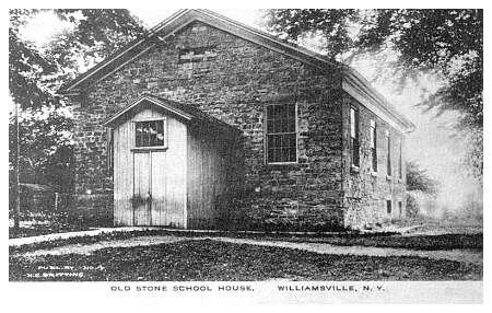
scajaquada street

Scajaquada Street

Scajaquada Street runs between Bailey Avenue and Grider Street on the east side of Buffalo, cut into two pieces by railroad tracks.  Scajaquada is the type of word that Buffalonians know, but the kind of word that immediately stumps out-of-towners, a relic of our Native American roots here in Western New York.  Both the street and the expressway get their names from Scajaquada Creek.  Did you know that Scajaquada Creek was named after a person?

The creek is named after Philip Conjockety.  His name was also spelled Kenjockety.  He was also known as Ska-dyoh-gwa-deh (meaning “Beyond the Multitude”), which was also spelled Skandauchguaty or Conjaquady.  There are estimated to be as many as 90 different spellings of the word.  No wonder we still have trouble spelling the word today!  (One of my favorite Buffalo jokes:  How do you spell Scajaquada?  “198”)  The Seneca name was commonly Ga-noh-gwaht-geh, meaning “after a peculiar kind of wild grass that grew near its borders”.  The grass was important to early settlers, because it was used to create woven baskets, fishing nets, and supplies.

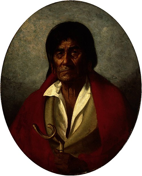
1850 Portrait of Philip Conjockety by Lars Gustaf Sellstedt

Philip had come to Buffalo with the Senecas shortly after the Revolutionary War, when they were driven away from the Genesee Valley.  Philip’s great grandfather was a member of the Kah-kwahs, who once lived in the Western New York area.  The Kah-kwahs were overtaken by the more powerful Senecas around 1651, and the survivors were adopted into the Seneca nation.  Philip’s father, John, became Chief of the Seneca, and was part of the influence which brought the Seneca Nation to the banks of the Niagara River near what became Scajaquada Creek when they left the Genesee Valley.

Philip was born near the Tonawanda Reservation and lived in Fort George during the Revolutionary War, when he fought with the Senecas against the Americans.

Philip died April 1, 1866, at Newtown, on the Cattaraugus Reservation.  When he died, the Courier reported at the time that he was the oldest resident of the region.  Some accounts listed him as 120 to 130 years old, but it was generally believed that he was nearly 100 when he died.  His mind was clear in his old age, so much of the early history of Buffalo was gathered from Philip’s stories.

During the War of 1812, the navy yard at the mouth of Scajaquada Creek was where five of Commodore Perry’s ships were reconditioned during 1813.  A plaque commemorating this location of this navy yard is on the Niagara Street Bridge, north of Forest Ave.   On South Side of the creek near its mouth was Sailor’s Battery – the last in a line of 8 batteries stretching from the Terrace to the Creek that helped defend during the War of 1812.   The Sailor’s Battery was the first to be overtaken during the night of December 29, 1813 during the Battle of Black Rock which led to the Burning of Buffalo.

Doreen-DeBoth-Buffalo-NY

“Battle of Scajaquada Creek Bridge” Artist: Doreen Boyer DeBoth

The Battle of Scajaquada Bridge was fought August 3, 1814.  British forces were attacked by American forces at the bridge, west of where Niagara Street crosses the creek.  The American forces were entrenched on the south side of the creek and began to dismantle the bridge to prevent the British from crossing.  The British attempted to rebuild the bridge, but failed and ended up retreating to Canada.  The outnumbered American men were able to stand up to the British men in what was the last act of British aggression towards Buffalo during the war.  The victory is described as a decisive engagement and a triumph for the United States.

By 1902, the area around the mouth of Scajaquada Creek had become a city dump.  The area was a popular place for “mouchers” to rifle through the discarded waste of the city to resell things.  Of the Scajaquada Creek dump, it was written:  ” Once it was a picturesque stream, but here its glory is departed.  It has banks of ashes six or eight feet high and between them flows the noble stream in a sluggish, dirty current.  Its channel obstructed by peach baskets, bottomless coffee pots, kerosene cans, bed springs, tin cans and other materials which the moucher rejects.”

Historic View of Scajaquada Creek Source: Buffalo News

In 1899, the National Motor Transit Company entered into a 1 year contract with the Park Board of Buffalo to operate an automobile transit service to travel along what would become, 60 years later, the route of the City’s first intra-urban highway, the Scajaquada Creek Expressway.  Four cars traveled from Lincoln Parkway past the zoo to Humboldt Parkway and Main Street every half hour.

Around 1946, New York State began planning for a system of highways throughout the City of Buffalo in a report titled Report on the New York State Thruway and Arterial Routes in the Buffalo Urban Area.  In 1951, the Buffalo Planning Commission adopted a Major Traffic Ways Plan that included the Scajaquada Expressway as a component of the system.  Traffic was quickly growing within the City and the highways were designed to find a place for the cars by channeling them onto expressways.  The Scajaquada Expressway was constructed during the 1950s and 1960s.   The route was designated by the Surface Transportation Act of 1982 as NYS Route 198.

Buffalo NY Courier Express 1958 a - 2435

Proposed plan for Delaware Park Shortway. Source: Courier Express, September 5, 1958

Other plans to create a second limited access highway was proposed for Delaware Park in 1958.  The “Delaware Park Shortway” would have run parallel to 198 across the north side of the Delaware Park meadow.  The City Planning board tabled the proposal in order to finish construction of the Scajaquada and Kensington Expressways to be completed before the Shortway was built, so plans never came to fruition.

Studies have been going on since the late 1990s regarding downgrading and/or removal of the Scajaquada Expressway, particularly the section through Delaware Park.

Historically, Scajaquada Creek was a shallow, wide, meandering creek.  Over time, the creek was channelized and portions were routed underground in three ares.  Residents would use the creek to dump their waste, creating a public health issue in the stagnant water.  Putting the creek underground would help resolve this issue, and created numerous pocket parks along the former length of the creek.  The largest tunnel was created as the Scajaquada Drain project in 1928.  This project buried 3.5 miles of the creek, from Pine Ridge Road to Forest Lawn Cemetery.  A portion of the buried creek runs under Scajaquada Street.

FotoJet

Top photo 1924.  Bottom photo modern image same site.  Corner Scajaquada Street and Kilhoffer during construction of Scajaquada Drain.  Source:  WNY Heritage.

During the 1930s, the sewer systems crossing the creek were disconnected, connected the creek into the city’s combined sewer overflow system.  The Delevan Drain was built to try to divert the combined sewage near Main Street, but it is designed to function during low flows, and during storm events or high flows, the water exits the Delevan tunnel and flows into the stream channel.  At Forest Lawn Cemetery, the creek is recharged by underground springs, and the Onondaga Escarpment creates Serenity Falls within the Cemetery.  When Delaware Park was originally designed, the 42 aces lake was formed by damming Scajaquada Creek.  As part of the Expressway construction, park, portions of the lake were filled.  The lake retains little of its original shoreline.  During the 1950s, the lake was declared by the Department of Health a health hazard and was closed to the public due to the sewage overflow issues.  The creek was rerouted to separate it from the lake in the early 1980s.  Buffalo Niagara Riverkeeper and other organizations are working to restore and provide environmental restoration to the creek.

So the next time you drive over the Scajaquada, think of Philip Konjockety, a highway that were never built, and a creek that’s been buried.  To learn about other streets, check out the street index.

Sources:
  1. Carstens, Patrick Richard and Timothy L. Sanford.  Searching for the Forgotten War – 1812.  Xlibris Corporation:  2012.
  2. “Death of Philip Kenjockety”.  Courier & Republic.  Wednesday Evening, April 4, 1866.
  3. OH Marshall. “The Niagara Frontier” Vol. II Buffalo Historical Society Publications
  4. Parke, Bill.  “Battle of Scajaquada Bridge”.  Black Rock Historical Society.  Online at http://www.blackrockhistoricalsociety.info/battle-of-scajaquada-creek-bridge.html
  5. Delaware Park Shortway. Courier Express. September 5, 1958.  Pg 6.
  6. Cichon, Steve.  The Buffalo You Should Know:  The Slow Death of Humboldt Parkway in Building the 33 & 198.  Buffalo News. May 8, 2016.
  7. NYSDOT.  NY Route 198 Scajaquada Corridor Study P.I.N. 5470.14.  June 2005
  8. WNY Heritage.  Scajaquada Drain Project.  Online at https://www.wnyheritage.org/content/scajaquada_drian_project_-_1920s/index.html
  9. Treasure at the Dump.   The Illustrated Buffalo Express.  1902.


Advertisement

Read Full Post »

streetPerry Street was originally named Beaver Street by Joseph Ellicott in the original 1804 Plan of New Amsterdam/Buffalo.  In 1907, Alderman Hendrick Callahan suggested new names for a bunch of streets.  The streets that he renamed were Liberty, Erie, Columbia, and Perry.  He also suggested renaming Main Street to Iroquois Avenue; however, this was not approved.  Liberty Street was later renamed Baltimore Street.  Perry also lends his name to the Commodore Perry projects, located near Perry Street.

Additionally, Perry Boulevard used to be located along the former route of the Erie Canal where the I-190 Thruway is currently located.  The road led from Main Street up to Porter Avenue, and was constructed when the canal was filled in during the construction of the Lakeview Housing Project.  At the time, the unused canal bed was considered a health hazard, so it was filled in to protect the residents of the public housing.  A short portion of the roadway under the Thruway is still called Perry Boulevard.

OliverHazardPerryEngraving

Oliver Hazard Perry

Oliver Hazard Perry was born in 1785 in Rhode Island.  His younger brother Matthew Calbraith Perry was involved in the opening of Japan. Matthew Perry also served under his brother during the Battle of Lake Erie.

Perry served in the West Indies, the Mediterranean, and the Caribbean, but he is best known as the “Hero of Lake Erie” for his role during the War of 1812.   At the start of the War of 1812, the British Navy controlled the Great Lakes, except for Lake Huron.  The American Navy controlled Lake Champlain.  The American Navy had only a small force, which allowed the British to make advances on the Great Lakes and northern New York waterways.

Perry was named Chief Naval Officer in Erie, P.A., and built a fleet on Presque Isle Bay.   On September 10, 1813, Perry fought a successful action during the Battle of Lake Erie.  During the battle, Perry’s ship, the USS Lawrence, was severely disabled.  the British Commander, Robert Barclay, thought Perry would surrender.  Commander Barclay sent over a small boat to request that the Americans pull down the flag.

1911 Painting of the Battle of Lake Erie by Edward Percy Moran.  Perry is standing in front of the boat

1911 Painting of the Battle of Lake Erie by Edward Percy Moran. Perry is standing in front of the boat

Perry remained faithful to the phrase “DON’T GIVE UP THE SHIP”, which were paraphrased from the dying words of Captain Lawrence, Perry’s friend and the ship’s namesake.  The men rowed through heavy gunfire to transfer to the USS Niagara.  Perry’s forces continued until Barclay’s ships surrendered.  Although Perry was aboard the Niagara during the fighting of the battle, he had the British surrender on the deck of the Lawrence to allow the British to see the price his men had paid.  Perry’s report following the battle was brief but became famous:  “We have met the enemy and they are ours; two ships, two brigs, one schooner and one sloop”.  This was the first time in history that an entire British naval squadron had surrendered.

Perry's Congressional Gold Medal

Perry’s Congressional Gold Medal

He was awarded a Congressional Gold Medal and for his role during the Battle of Buffalo.  He also helped completed successful outcomes at all nine Lake Erie military campaigns, which was a turning point during the War of 1812.

The Perry statue in Front Park was erected by the State of New York Perry Victory Centennial Committee.  The statue was dedicated at the 100th annual reunion of the New York Veterans Association.  The statue has recently been restored and returned to the park, along with cannons that were originally located in the park due to the park’s connection to Fort Porter, which was located near where the Peace Bridge plaza is currently located.

statue

Perry Statue, Front Park

Commodore Perry did not live to old age.  He died in 1819, on his 34th birthday, of yellow fever while at sea.  He was buried at Port of Spain, Trinidad with full military honors.  In 1826, his remains were moved to Newport, Rhode Island.

Learn about the origins of other street names by checking out the Street Index.

Sources:

  1. “What Think You Of These Names” Buffalo Express May 31, 1907
  2. News May 6 1937 (clipping in local street scrapbook vol 2)

Read Full Post »

Hopkins Street in South Buffalo

Hopkins Street in South Buffalo

Hopkins Street is a north-south thoroughfare in South Buffalo.  The road leads from South Park north towards the Buffalo River.  Historically this area was a mix of commercial and industrial uses, connecting the steel mills to the adjacent South Buffalo neighborhoods.

Hopkins Street is named for Brigadier General Timothy S. Hopkins, a War of 1812 general.    Hopkins Road in Amherst is also named General Hopkins.

The Hopkins family descended from Stephen Hopkins, who came over on the Mayflower.  Oceanus Hopkins was born aboard the Mayflower.  Most history books list Oceanus as a son; however, Hopkins family lore indicates that the family was bad at latin, she was a girl and should have been thus named Oceana.  A second Stephen Hopkins signed the Declaration of Independence and Ichabod Hopkins signed the Constitution in Philadelphia on behalf of Massachusetts    Ichabod Hopkins had a son, Timothy Soveral Hopkins.

Timothy S. Hopkins

Timothy S. Hopkins

Timothy S. Hopkins was born in Massachusetts in 1776.  He arrived in Clarence at the age of 22, arriving by foot.  He then purchased land in 1804 from the Holland Land Company.  Mr. Hopkins is said to have grown the first wheat on the Holland Purchase, on a farm in Clarence Hollow.   When it was ready to be ground, he had to travel to Street’s mill at Chippewa, a village that became a part of the City of Niagara Falls, Ontario.  This was a distance of 40 miles!  The trip took four days and included a ferry ride from Black Rock, where only one family resided – the family of the ferry owner!  Timothy married his wife Nancy Kerr in Williamsville; their marriage was the first recorded marriage in Erie County.  They settled on Main Street on a farm in Snyder, near where Amherst Central High School is currently located.

Burning of Black Rock, December 1813

Burning of Black Rock, December 1813

During the War of 1812, Mr. Hopkins rose through the rank to Brigadier General.   He was an important part of the Battle Of Buffalo (also known as Battle of Black Rock), where he was stationed in Black Rock.  Following the war, he resigned from his post.

In 1819, he became the first Supervisor of the Town of Amherst and later served as Justice of the Peace.  His reputation spread through the area, and he was elected Sheriff of Erie County.  He was later elected to the New York State Assembly.

The Cayuga Street Stone School

The Cayuga Street Stone School

The Cayuga Street stone school-house in Williamsville was built by Timothy S. Hopkins in 1840 and still stands in Williamsville at 72 Cayuga.  He died January 23, 1853.

Nelson Hopkins grave

Nelson Hopkins grave

Nelson Kerr Hopkins, Timothy’s son, owned much of the land which included Hopkins Street.  Nelson subdivided the land into building lots and named the street after his father.  Nelson served as President of the Common Council of Buffalo and was New York State Comptroller from 1872 to 1875.  Nelson also organized the City’s first paid fire department and served as fire commissioner for ten years.  Nelson died in 1904 and is buried in Forest Lawn.

Timothy A. Hopkins

Timothy A. Hopkins

Nelson’s brother, Timothy Augustus Hopkins owned the Eagle Hotel in Williamsville, which is now known as the Eagle House.   He also operated a mill near the Eagle House, served as Justice of the Peace and Erie County Sheriff.  Timothy A. Hopkins is responsible for building a bridge over the Erie Canal in the Tonawanda Creek area, and constructing drainage ditches in the northern part of Amherst to reclaim thousands of acres of land that were often covered by spring floods after a dam was placed near the mouth of Tonawanda Creek for canal purpose.  Timothy A. Hopkins passed away in 1894 and is buried in Williamsville Cemetery.

The Hopkins Street area is currently a part of the City of Buffalo South Buffalo Brownfield Opportunity Area (BOA).  This study being done by New York State is working to revitalize the neighborhood by cleaning up vacant industrial sites and marketing properties for redevelopment.  More information about the South Buffalo BOA can be found through Buffalo Urban Development Corporation.

Be sure to check out the Street Index to learn about other streets!

Sources:

  1. “Hopkins Street named for 1812 General” Courier Express.  Oct 30 1939, sec 6 p 4.
  2. Larned, Josephus Nelson.  The Progress of the Empire State:  the History of Buffalo.  Published by The Progress of the Empire State Company, New York:  1913.
  3. Smith, Henry Perry.  History of the City of Buffalo and Erie County, Volume 1:  1620-1884.   D. Mason & Co Publishers, Syracuse NY: 1884.

Read Full Post »

Hidden Waters blog

Companion blog for the book "Hidden Waters of NYC"

DenCity

Urban History Blog

Hoping for a Tail Wind

Because I definitely brought way too much gear.

priorhouse blog

Photos, art, and a little bit of LIT.

Sheepie Niagara

The most popular sheep in Niagara Falls

Nonprofit AF

Exploring the fun and frustrations of nonprofit work

Gather by Image

An anagram. And a reason to write... to Grieve... to Heal