 Today’s post is is a little different. We’ll be learning about JFK Park. Unlike most of our posts, we’re not going to look much at the person for whom this was named, but rather the circumstances that created the park. You can google President John Fitzgerald Kennedy if you’d like to learn more about him – there are plenty of books, movies, documentaries about him – see Note 1 for recommendations. JFK Park and the Community Center were created in the 60s, and, like many things built following President Kennedy’s death, named after him.
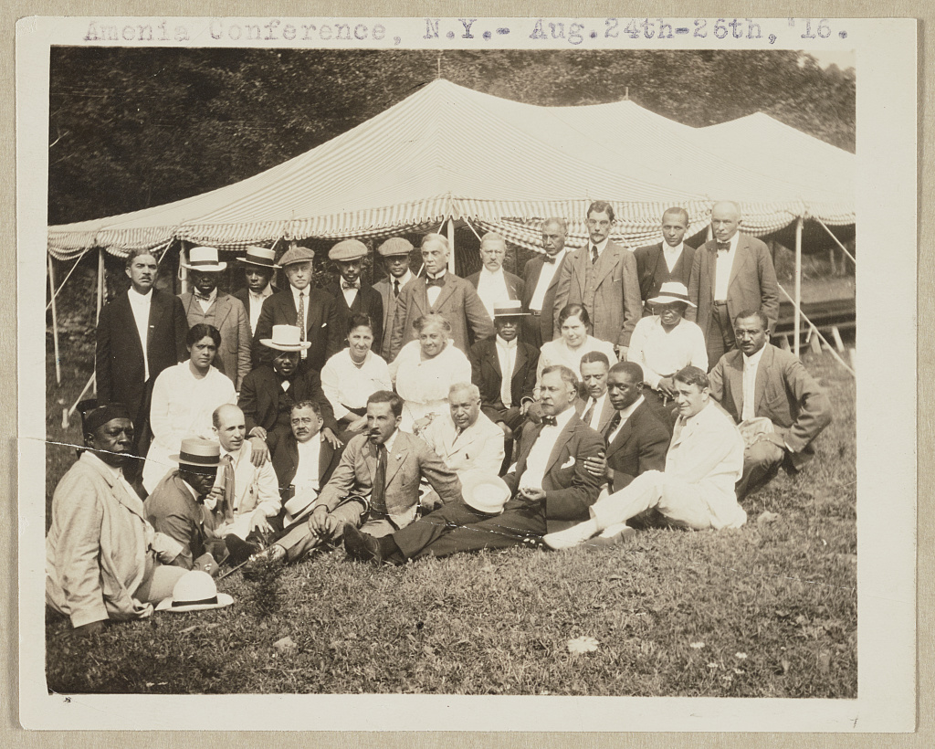
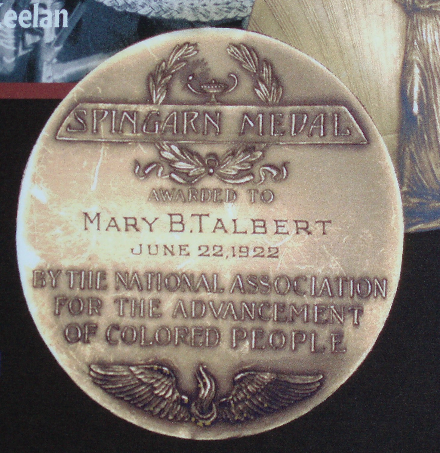
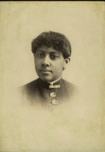
I spent the summer knee-deep in the history of the neighborhood surrounding the park, researching for the blog. I have written about the Ellicott Mall on one end, and the Talbert Mall on the other. To learn more about the Ellicott and Talbert Malls, and about the namesakes of some of the streets that run through this area, you can read the following posts:
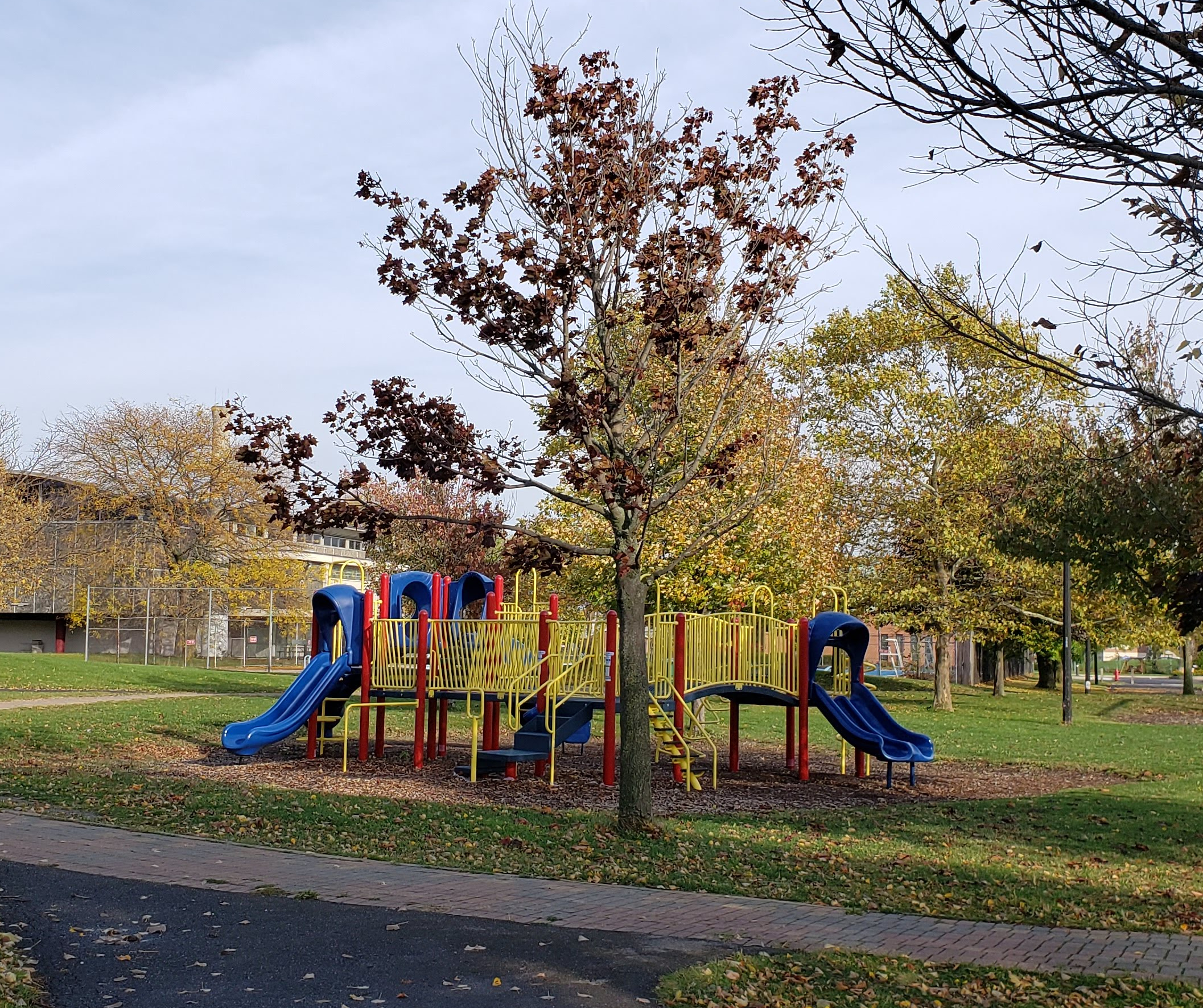
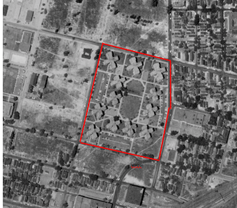
 JFK Park fills most of the space between the Ellicott Mall and the Talbert Mall. This is also my neighborhood park, and I’ve spent a lot of time here the last few months during the pandemic. I walk through the park often during my daily walks. Sometimes, I’ll bring a blanket to sit and read while listening to kids play in the playground and (during non-pandemic times) on the ballfields, basketball court, pool, and tennis court. The photos I’m sharing here lack people out of respect for not wanting to post pictures of children without consent, but even during the pandemic, this is a well used and well-loved park. It also serves as recreation space for the JFK Community Center, Bennett Park Montessori (PS #32), and Buffalo Elementary School of Technology (PS #6).
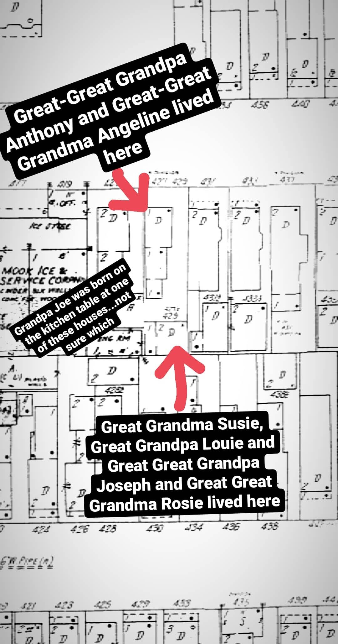
427 and 429 N Division
This is also the place where my Italian immigrant family’s roots here in Buffalo started. My Great-Great Grandparents Anthony and Angeline Valerio lived across Hickory Street from what is now the park, at 429 North Division Street. Anthony and Angeline’s daughter, my Great Grandma Susan married my Louis Violanti at St. Columba Church in September 1927. The church has merged with St. Brigid’s and has built a new building, but it is still located near the same spot on Hickory, across from JFK Park. The Violantis moved into 427 North Division Street, located right in front of the Valerio’s house at 429 North Division, along with Louie’s parents – my Great-Great Grandparents Joseph and Rosie Violanti. My Grandpa, Joe Violanti, was born on the kitchen table at one of these houses in December 1928. One generation later, the entire neighborhood as they knew it was gone.
This neighborhood was called the Ellicott Neighborhood. It’s a name that isn’t used much anymore. Sure, there’s the Ellicott Council District, but you don’t hear people refer to the neighborhood as much any more. It may have had earlier names as well, before it was called Ellicott, I often struggle to find information about historic neighborhood names. If you know, I’d love to learn more. Like much of the East Side, it’s identity is lost and it’s lumped into a larger area. It gets assigned a vague description “the area between Downtown and Larkin”. It was demolished, and therefore lost much of its identity.
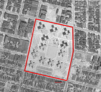
This park that I love so dearly was 7 blocks of active city life. In 1950, the neighborhood looked like this:
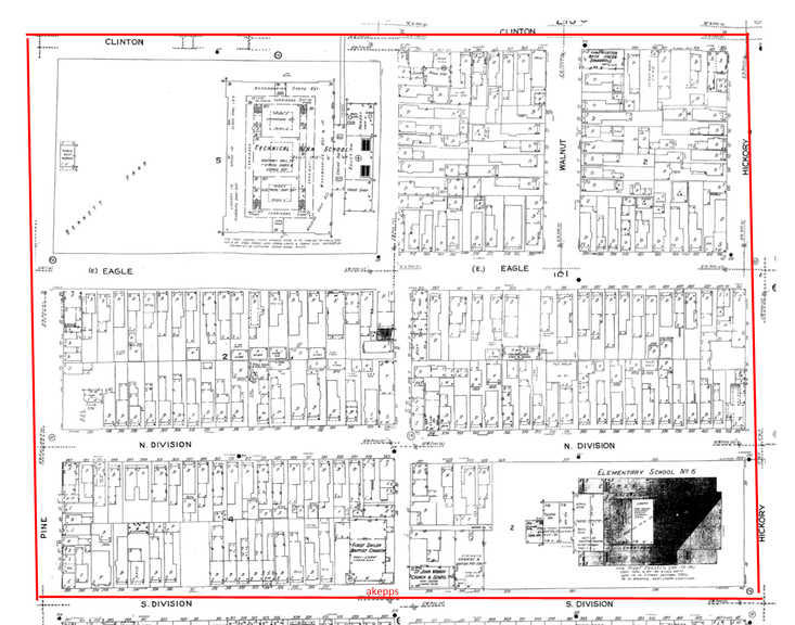
Sanborn Map of JFK Park area in 1950
In 1950, there were 253 buildings with the following uses: 36 stores, 3 schools, 2 restaurants, 2 churches, 1 synagogue, 1 junk exchange, 1 contractor’s yard, 1 filling station, 1 clubhouse, 197 private dwelling units, 4 buildings of flats, and 3 apartment buildings. At the time, a private dwelling referred to a building that was home to up to two families, flats referred to a frame structure where a family occupied each floor (the common Buffalo upper-lower houses).

288 South Division Street in the 1950s. Now part of JFK Park. Source: WNY Heritage
What remains of those 253 buildings? Just two buildings, both are schools – the former Technical High School, now administrative offices for the Buffalo Public Schools and other is PS 6, still an active elementary school.
In 1950, the average household size in Buffalo was 3.4 people per dwelling unit. Assuming that there were 2 units in each of the flats buildings and 4 units in each apartment building, that gives a conservative population of about 737 people on these seven blocks. (For comparison’s sake, the average number of people per dwelling unit in 2018 is 2.24)
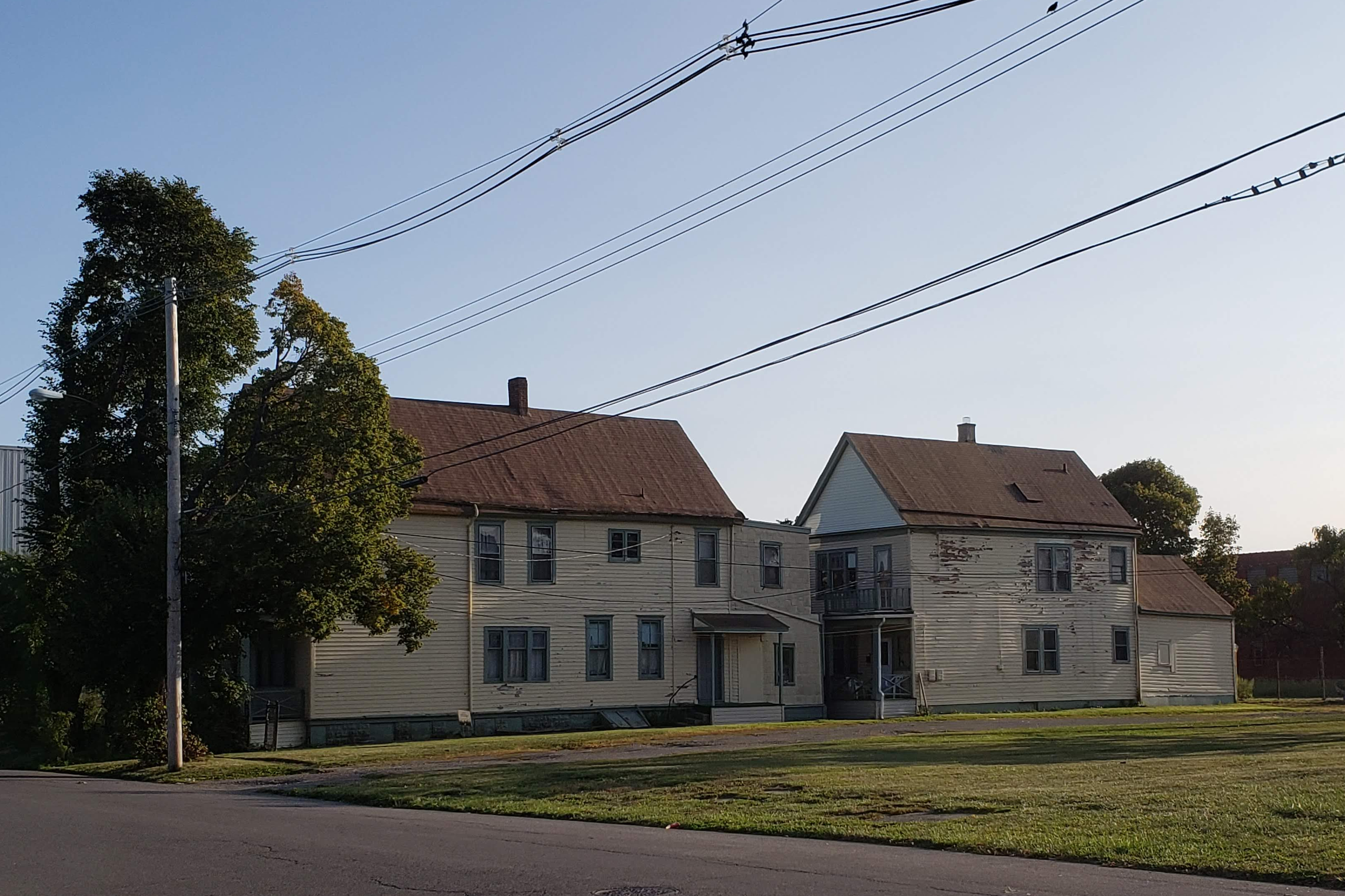
Example of houses stacked on a lot. Picture houses on either side of these houses as well to picture how dense the neighborhood was.
This is just 7 blocks, and we demolished at least 32 blocks of this area, basically everything surrounded by William, Jefferson, Swan, and Michigan. Picture if the Allentown Neighborhood was shifted from north of Downtown to just east of Downtown, that’s about how dense the Ellicott Neighborhood was, except it was actually even more dense. A common thing in this neighborhood was houses stacked on lots – so there’d be both a front house and a back house on the lot. You can still see evidence of this on some of the blocks there weren’t completely demolished, and on the historic maps showing just how many houses were crammed onto these blocks.
“Urban Renewal” is typically used to refer to a series of programs that were used by cities in the middle of the 20th Century to address urban decay in cities. The programs cleared out blighted areas of cities by clearing out areas that were declared slums. The programs were designed to replace the “slums” with new, higher class housing and new businesses. Often, the projects were implemented by local public housing authorities, which is the case in the Ellicott Neighborhood Redevelopment projects.
Most urban renewal programs involved municipalities taking land within a designated urban renewal area by purchasing properties or taking the properties by eminent domain. The properties would then be razed and selected developers would build a new development on them.
The Housing Act of 1937 created the US Housing Authority, a federal corporation able to loan money to states and local governments to build housing for those unable to find suitable housing themselves. Under this act, one housing unit of slum clearance resulted in one unit of new modern low-income housing built. About 150,000 units of housing were built across the country under this act before the start of WWII. Most of the housing authorities found that new housing alone was not enough to remove the slums and provide urban redevelopment. The new housing often became the new slum a few decades after it was built. The idea became that we need urban renewal- including housing, zoning, schools, enforcement of health standards, transportation, and minimization of racial restrictions.
The GI Bill (The Serviceman’s Readjustment Act), passed in 1944, allowed veterans to obtain mortgages, allowing many to purchase houses in the suburbs.
The Housing Act of 1949, also known as the Taft-Ellender-Wagner Act, provided loans to cities to acquire and clear slum areas to be sold to private developers to develop under a plan prepared by the city. The act also provided grants to cover up to two-thirds of the city’s costs. Under this act, the programs implemented were known as “urban redevelopment”.
The Housing Act of 1954 made these projects more profitable by providing mortgages backed by the Federal Housing Administration. Programs implemented under this act were known as “urban renewal”.
The first major modern Urban Renewal project was completed in Pittsburgh in 1950. This project demolished a portion of Downtown Pittsburgh and converted it to parks, office buildings, and a sports arena (the former Mellon Arena).
Urban renewal programs had an immense impact on our cities. Highway construction was often a part of urban renewal programs – getting cars out of crowded city streets and routing them onto highways to allow people to get places more quickly was the reason so many urban highways were built during this era. These highway projects had the additional consequence of exacerbating sprawl, as they allowed people to live further away from Central Business Districts in the suburbs and commute to work via the new highways.
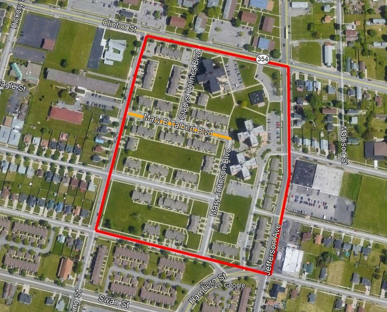
 In 1955, Buffalo Common Council designated the 160-acre Ellicott District Redevelopment Project Area to be totally cleared and rebuilt except for religious and education buildings. This was the first Urban Renewal project in New York State – designated with project number NYR-1. In December 1957, a $10 Million Capital Grant (approximately $92 Million in 2020 dollars) was funded to begin to acquire the 1050 parcels and relocated residents and businesses. In 1961, a $600,000 ($5 Million in 2020) addition was added to PS 6 and $450,000 ($4 Million in 2020) in renovations were completed a the Former Technical High School (at the time, it was Clinton Junior High). 25 acres were set aside for the $1.5 Million ($13 Million in 2020) Elliott District Recreation Center, which became JFK Park.
The Urban Renewal Area was appraised in 1959 and there were 2,219 households in the area. Average household size was 4 people, and a total population of 8,836 people. There were 1004 parcels, 1447 improvements (buildings), and 2,215 dwelling units. Most of the dwelling units were 2 and 3 family buildings. Seventy percent of the buildings in the area were classified as substandard. When inventoried, there was only a vacancy rate of 2% throughout the neighborhood. There were 81% rental units and 19% owner-occupied units. At the time, the City considered a slum and blighted area to be when there were fewer than 45% owner-occupied units.
Relocation continued for 27 months. In total, 1600 family groups and 400 roomer households were relocated. Others had left on their own volition when they saw the writing on the wall, or just the normal course of moving due to life circumstances. The average household size of households relocated by the government was 3.14 people. The average length of time of residence before relocation was 7 years, with owners having a longer tenure in the neighborhood than the renters. Black owners in the neighborhood had lived there an average of 12 years. The white owners in the neighborhood, in particular, had lived there for a long time, with 50% of white owners being 60 years or older and 67% of them had lived in the neighborhood 20 years or more. Most of the relocated families, approximately 70%, remained in the Ellicott District or moved north into the Masten District.
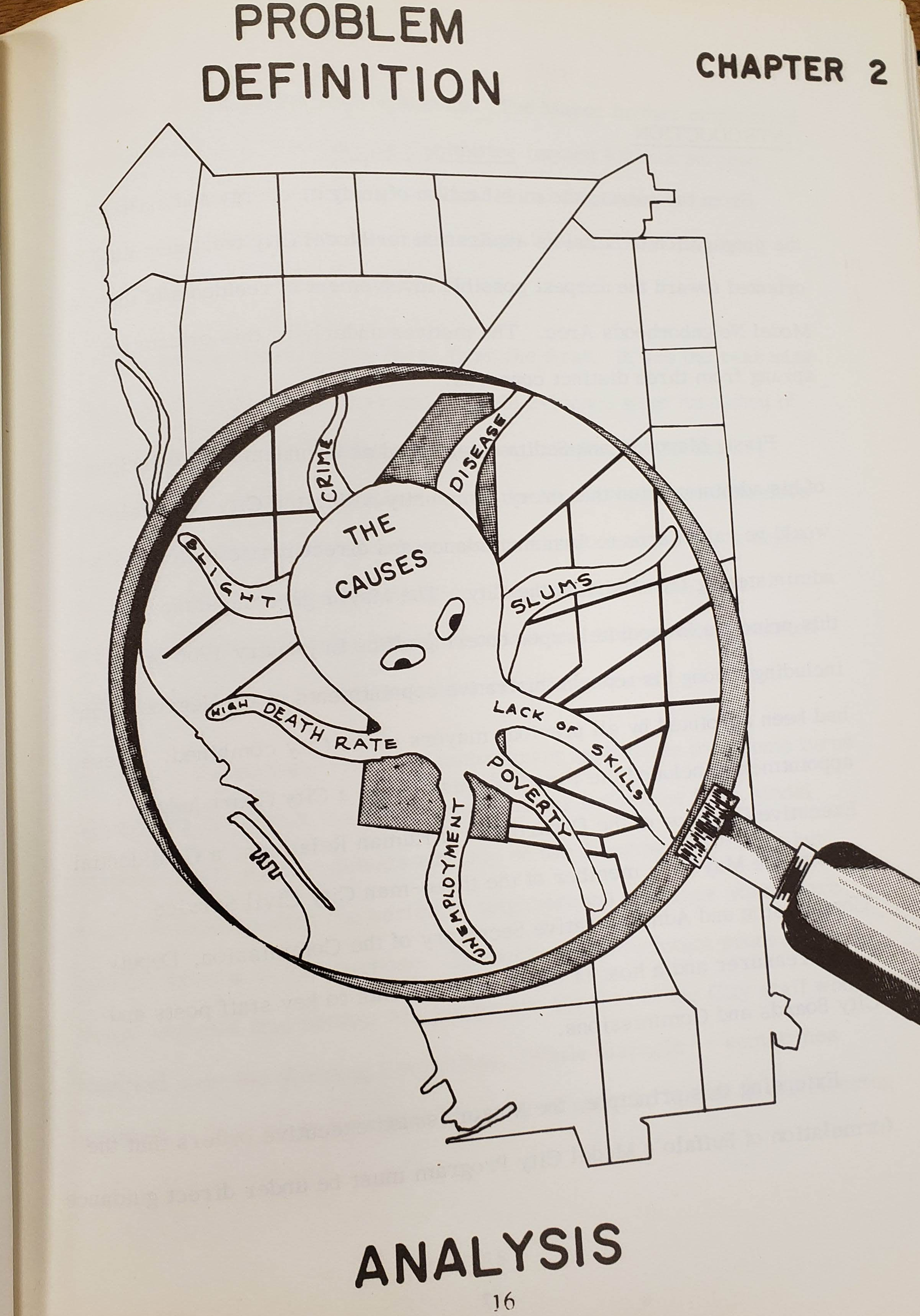
Graphic showing the “problem neighborhood” as an octopus
The housing here in the Ellicott Neighborhood was some of the oldest in the city. Most of the housing was a typical 2.5 story frame structure with a peaked roof and a front porch that you see throughout Buffalo. It was run down and crowded. The Ellicott Neighborhood was labeled as the highest in the city in terms of crime, delinquency, disease, and mortality. In the 1950s, Buffalo was the 15th largest city in the Country, but still had the same boundaries as it did in 1854 (and basically still same area today). As Buffalo grew, many people were tired of the crowded dirty inner-city neighborhoods. Swan Street, just south of here, was once the fashionable neighborhood where “important” people lived – Mr. Blossom, Mr. Tillinghast, Mr. Pratt, to name a few. The rich started to move out to areas where they could have larger houses in the Elmwood Village or mansions along Delaware Avenue. Even regular folks started to want to move into houses in newer, less crowded sections of the City. The blocks between Seneca Street and the Thruway were particularly run down during the 1950s because they had originally been designated as the route of the NYS Thruway. The Thruway shifted south to the railroad corridor, but structures had seen little maintenance and improvements as they had been planned for demolition for highway construction.
Redlining by banks allowed mortgages for white people to move to new houses in newer sections of the city, or in the suburbs. Mortgages and housing loans were not granted to Blacks. This meant that the worst, most crowded housing was often all that Blacks moving to the North during the Great Migration could afford, mostly the housing that was being left behind by those moving into the newer neighborhoods. This furthered decline in the Black neighborhoods as there was no new money coming into the neighborhoods or new investments happening in the neighborhoods.
The City of Buffalo had at least 44 Urban Renewal Plans. The “Ellicott District Redevelopment Project” was approved by Common Council on August 2, 1957. The area was described as “predominantly residential in use but characterized by predominance of substandard and insanitary dwellings, the infiltration of mixed commercial and industrial uses, obsolete subdivision, undesirable street layout and traffic hazards, overcrowding of families, and inadequate public utilities and community facilities”. The plan was to divide the land use in the area as follow: medium density housing suitable for middle-income and lower middle income families (63.18 acres), expansion of public schools and public recreation areas (26.99 acres), community business districts (8.31 acres), existing public school sites (6.94 acres), land for expansion of existing charitable organizations (13.12 acres), existing charitable institutions (3.07 acres), and streets (39.78 acres). (161.39 acres total)
My Great Grandparents, they moved to South Buffalo. Their new house on Ladner Avenue was much closer to Great Grandpa’s job at the steel mill and they were able to own a large two-family house, with lots of land around it for Great Grandpa Louie to grow his large gardens. South Buffalo was kind of like the suburbs back then, but easily accessible via streetcar. Their house was at the end of a row of houses, with nothing beyond their home except fields. My other set of Great Grandparents lived one street over, on West Woodside, and the two families would cut between the fields to get to each other’s houses. I am not sure of the exact circumstances of their move. At the time, there was a lot of discrimination against Italians, but my family was likely able to benefit by their ability to purchase a home outside of the crowded inner city.
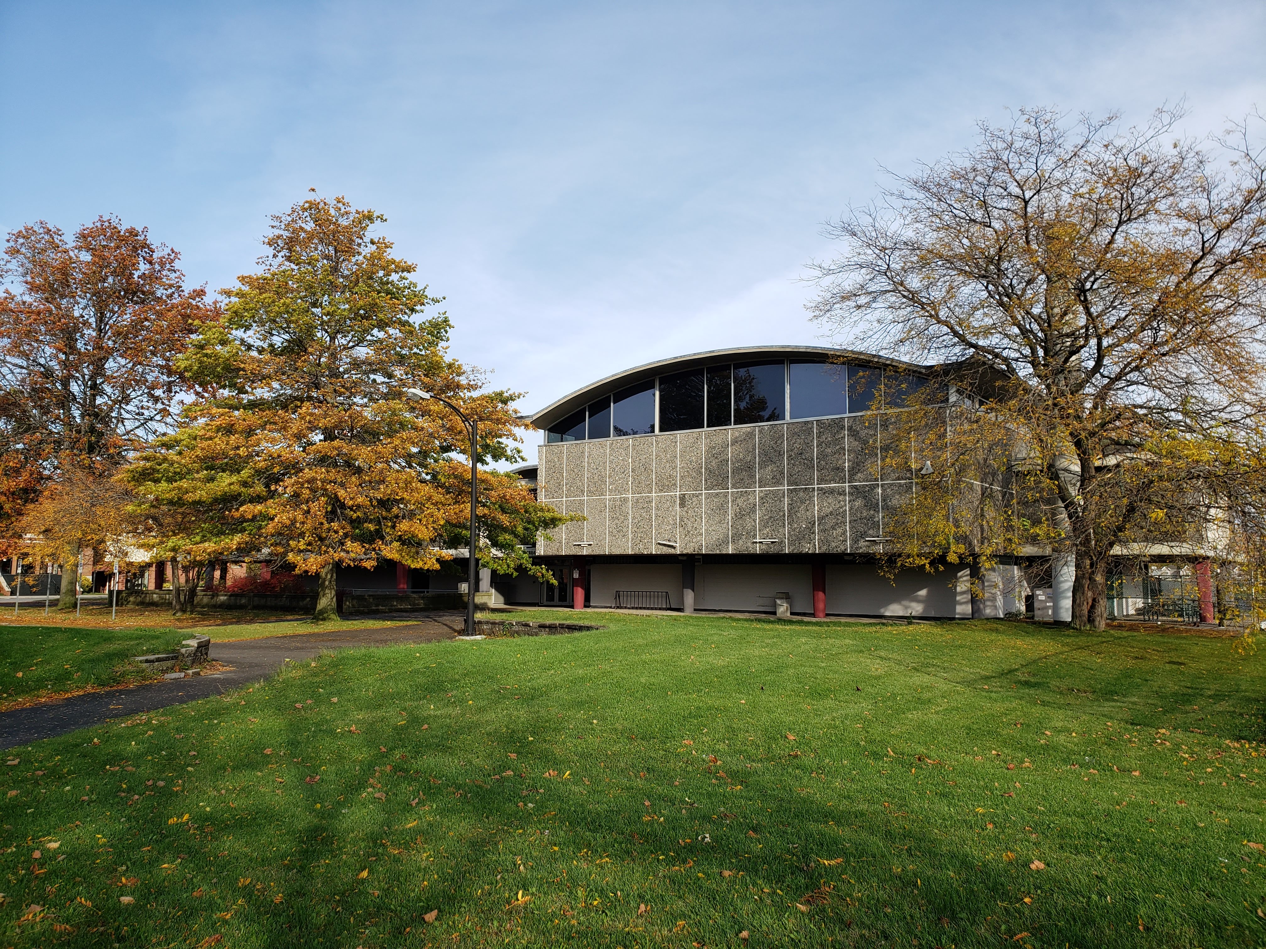 Robert T. Coles, the Buffalo-born architect, wrote his thesis in 1955 at MIT about a plan for Recreational Facilities in the Ellicott Community Renewal Area. In 1960, Robert Coles returned to Buffalo and was placed in charge of programming, design, and construction supervision of the recreation center that became JFK Community Center. The Rec Center building is a great example of Coles’ modern architecture style.
The lead demolition contractor on the project for the JFK Park project was Schwab Brothers. The Schwab Brothers were a demolition company from Buffalo that eventually had offices across the country – they became the largest demolition company in the country and held the demolition contract for the old Madison Square Garden and the old Yankee Stadium. Robert Coles teamed up again with Schwab Brothers to form Mid City Gardens, Inc, which designed the Mid City Gardens Apartments. The plan that had been created for the Ellicott Redevelopment Area was determined not to be urban enough for the area, so the Schwab Brothers proposed their plan. The plan looked at closing streets to prevent traffic congestion and keep local traffic moving – Clinton Street was disconnected from Downtown at this time, making William Street the main east-west thoroughfare to serve this neighborhood. William Street was widened at this time to its current configuration. Mid City Gardens consisted of 1,370 dwelling units and off street parking for each unit. The units were in a combination of high and low-rise buildings with “breathing room” between them. Two-story garden apartments were grouped with their own parking area and play space. There were 616 units in towers and 74 in garden apartments. The towers consisted of 77 units ranging from studios to two bedrooms and the garden apartments were two-story 3 and 4 bedroom units.
What eventually got built was garden apartments – the Ellicott Park Apartments, Towne Gardens, etc and single-family housing along William Street. Clinton Street was eventually reconnected through to Michigan and single family housing was built along there as well. The neighborhood is still home to three schools, five churches and is anchored by JFK Community Center in the middle of it all.
In the 1960s, novelist James Baldwin called Urban Renewal “Negro Removal”, after the way that the programs targeted neighborhoods primarily lived in by Blacks. As we’ve looked at in our previous posts about the Ellicott Mall and the Talbert Mall, the housing projects created by Urban Renewal programs were often not successful. High-rise towers often saw an increase in crime. The buildings were built quickly and inexpensively, so they often were run down quickly, without money to cover maintenance costs. While I covered an overview of urban renewal, this is by no means a conclusive study and I recommend looking into other sources for additional information. Public housing projects were built and demolished in many areas, not just in Buffalo (See Note 3 for additional resources).
 So the next time you’re walking through JFK Park, or any park or neighborhood, think about what used perhaps used to be there. Neighborhoods change over time, both my forces we can control and by those we cannot. Our cities are built on what came before. There might be more to the story than what you first see. A peaceful park might have been a whole neighborhood that no longer exists. Take a moment and remember.
We’ll be back to talking about streets in my next post – which will about William Gaiter Parkway. Some of you may remember Bill, who was a founder of the Juneteenth Festival here in Buffalo. Stay tuned for that! If you’d like to learn about additional streets, please check out the street index.
Note 1: If you’re looking for a biography about JFK, I recommend An Unfinished Life: JFK 1917-1963 by Robert Dallek or Jack: A Life Like No Other by Geoffrey Perret.(Side Note from Angela: in addition to Buffalo history and streets, one of my other hobbies is reading political biographies.)
Note 2: You can read the City of Buffalo Urban Renewal Plans here: City of Buffalo Planning Library
Note 3: For more information about public housing and urban renewal , I recommend watching the following documentaries: The Pruitt-Igoe Myth, about a housing project in St. Louis, Ken Burns East Lake Meadows, about a housing project in Atlanta, and James Baldwin’s Take this Hammer about San Francisco. For more about what happened locally, I recommend reading Partnership for the Public Good’s report: A City Divided: A Brief History of Segregation in Buffalo.
Sources:
- US. Department Of Commerce, Bureau of the Census. “1950 Census of Population Preliminary Reports: Characteristics of the Population of Buffalo, New York”. Washington, D.C. May 14, 1951.
- City of Buffalo. “Redevelopment Project for the Ellicott District Redevelopment Project”. August 2, 1957, as amended Oct 5, 1971.
- Cities Under Austerity: Restructuring the US Metropolis.
- Coles, Robert T. Community Facilities in a Redevelopment Area. Thesis submitted for the Degree of Master of Architecture, Massachusetts Institute of Technology, September 1955.
- Rashbum, William and Charles Bagli. “Demolition Man”. The New York Times. July 23, 2009.
- “MidCity Gardens: A Proposal for the Ellicott District Redevelopment Area” Schwab Brothers – Developer, Robert T Coles – Architect. undated. From the Collection of the Grosvenor Room, Buffalo Library – HT177.B8 S34
- Davidson, Mark and Kevin Ward. Cities Under Austerity: Restructuring the US Metropolis. State University of New York Press, Albany. 2018.
- Buffalo Municipal Housing Authority. Ellicott Relocation: A Preliminary Report. March, 1961.
- Brown, Harris, Stevens, Inc. Appraisal Report Ellicott District Urban Renewal Area, Buffalo NY. Prepared for the Board of Redevelopment, City of Buffalo. April 14, 1959.
Read Full Post »

 Charles Person was born in Alsace-Lorraine in 1827. He came to Buffalo in 1841 at the age of 14. He worked in a liquor business learning the trade. At the age of 23, he started his own liquor business.
 Mr. Person’s business, C. Person’s Sons was the city’s “foremost whiskey rectifier”. Charles started the company in 1850. He sold his whiskey wholesale from 390-392 Elm Street next door to the family home. His firm was the largest liquor warehouse in Buffalo. Their building is currently part of the site that is presently the Catholic Health Headquarters. The company was well known, not just in Buffalo but throughout New York, Pennsylvania and Ohio. Two of their brands were Buffalo Club Whiskey and Riverside Whiskey. The whiskey business continued for three generations until prohibition. For the two weeks before Prohibition started, the line outside of their business went for blocks, everyone stocking up on whiskey. To understand the size of the business, when the doors closed, they still had 2,000 barrels of bonded whiskey remaining! One of the grandsons reported that they kept the whiskey at his house, and that they still had stock into the 1940s! During Prohibition, there were 4 attempted robberies at this house, so he had a special vault constructed to store the whiskey.


 Wasmuth Avenue runs between Genesee Street and Walden Avenue near Martin Luther King Jr Park on the East Side of Buffalo. The street is named after one of the first female developers in Buffalo, Caroline Wasmuth. Ms. Wasmuth was one of Buffalo’s pioneer business women.
 Ms. Wasmuth was married twice and had four sons and five daughters: Frank, George, Maggie, Lillian, Anna, Caroline, John, Fredrick, and Charles. The family lived on Michigan Street (now Ave) near Carlton Street, on what is now the Buffalo Niagara Medical Campus. She was also one of the investors in the Pan American Exposition, having bought a subscription in 1899. She died in 1904 at the age of 75. She is buried in Forest Lawn Cemetery.
  Van Gorder Street is a short street located off of Fillmore Avenue in the Fillmore-Leroy neighborhood of Buffalo. The street runs one block east of Fillmore Ave where it dead-ends at Burgard High School (PS #301).
 The street is named after Greenleaf S. Van Gorder, a politician and banker.