Feeds:
Posts
Comments

Posts Tagged ‘City Honors’

fosdick

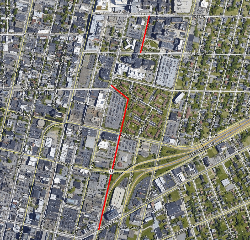
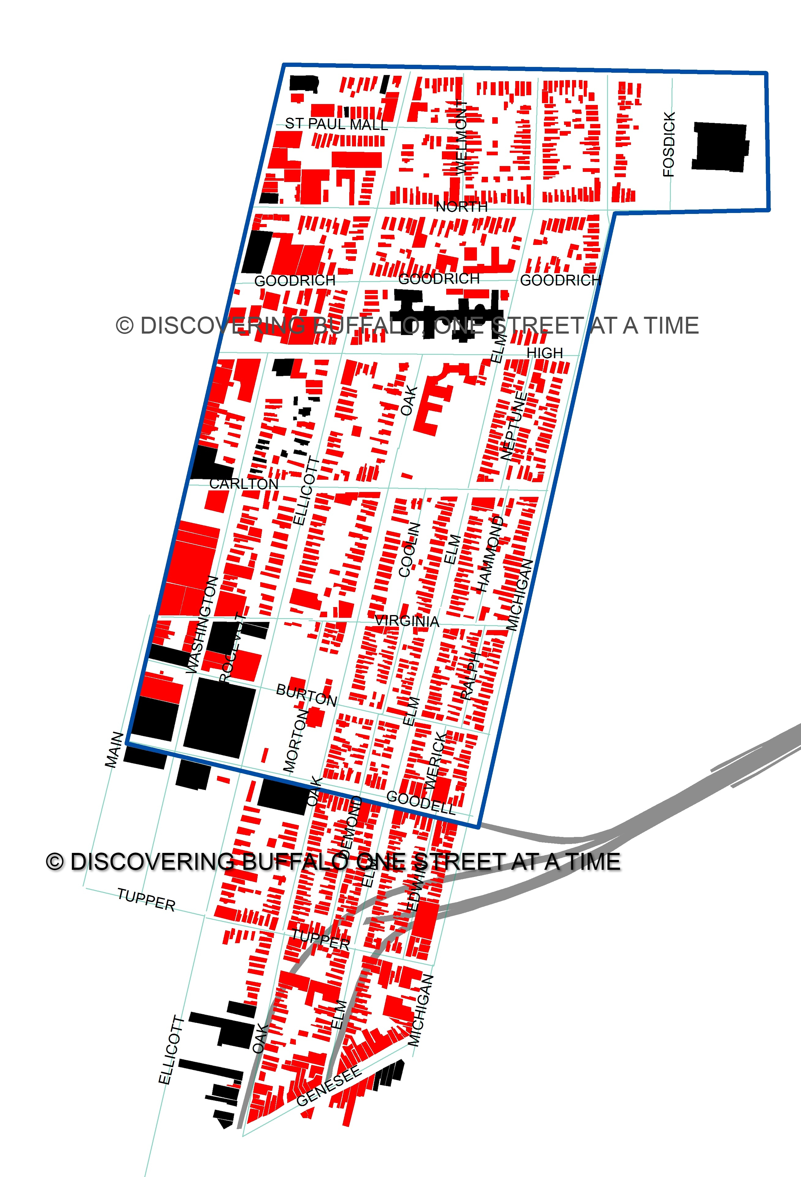
Map showing Fosdick Avenue in Red

Fosdick Ave is a short, one-block, one-way street between North Street and Best Street.  The street is adjacent to City Honors High School, the former Fosdick-Masten Park High School.  Fosdick Ave is a relatively new street, especially for this part of the City of Buffalo.  The street was created in 1977.  Fosdick Ave is named for Frank Fosdick, principal of Masten Park High.  The street is referred to as Fosdick Avenue in many newspaper articles, city documents, and on Google maps, so I will refer to it as Fosdick Ave, however, the street signs do say Fosdick Street.

The Fosdick family has been in America since the 1600.  They have been in Western New York since 1819 when Solomon Fosdick, his wife Anna, and their nine children traveled across New York State in a covered wagon to settle here.  They stopped in Buffalo, which was still rebuilding after the Burning of Buffalo, and then headed to the Boston Valley twenty-two miles southeast of Buffalo.  Boston at the time was a tiny settlement on the banks of 18-Mile Creek, with about two dozen families.  Solomon was a carpenter and was involved in building many buildings in early Boston.

john fosdick

John Fosdick, Frank Fosdick’s Father

Solomon and Anna’s eight child was John Spencer Fosdick.  He was two years old when the family traveled to WNY.  John attended school in the schoolhouse in Boston and then attended Springville Academy (now Griffith’s Institute) and then the Boston Academy when it opened in 1834.  The school year at the time was only 3 to 4 months of the year, so John worked with his dad on carpentry and building projects when he wasn’t in school.  Solomon and John built the Presbyterian Church in Boston in 1837.  The church is still standing and is now the Boston Historical Society Museum.  In 1836, John became a teacher at the Common School in Hamburg.  John continued in the carpentry business during non-school months.  In 1841, John married Eunice Andrews and they moved to Randolph, NY, where he taught in the school there.  A son, Charles, was born in 1842.  A year later, Eunice died suddenly in September 1843.  Her death prompted him to move to Buffalo.  In fall 1843, he was appointed a principal of the Grammar Schools in Buffalo.  He worked within the Buffalo Public Schools for the next 26 years and was known around town as “one of the great teachers of his generation”.  In 1845, he married Mary Blain, daughter of Reverend Jacob Blain, minister of the Dearborn Street Baptist Church in Buffalo.  Mary was also a teacher with the Buffalo Public Schools.

John Fosdick was later Superintendent of Education for Buffalo from 1866-1867.  While he was superintendent, he instituted qualifying exams for teachers, which was a revolutionary idea at the time.  He decided that high standards in teacher were going to be enforced and maintained in all of the Buffalo Schools.  John and Mary moved to Westfield in Chautauqua County in 1869 and John Fosdick worked at the Westfield Academy for 9 years and served on the Westfield Board of Education for 3 years.

John was a member of the Free Soil Party, which was for free soil, free speech, free labor, and free men.  John reportedly served as a conductor on the Underground Railroad and helped bring runaway slaves across the Niagara River into Canada.  The Fosdick home at 677 Ellicott Street, the SE corner of Virginia Street, was a place where slaves would come to be taken across the river.   Unfortunately, the house was demolished during Urban Renewal of the Oak Street neighborhood.

frank fosdick

Frank Fosdick. Source: Buffaloah.com 

Frank Fosdick was born March 11, 1851 in Buffalo to John and Mary Fosdick.  Frank attended School 14 (Franklin Street School, between Edward and Tupper), where his father was principal and his mother was a teacher.  Mr. Fosdick attended Central High School and then received a Bachelor of Arts from University of Rochester in 1872.  After graduating from U of R, he became a teacher at Buffalo Classical School (sometimes called Dr. Briggs School).  In 1873, he was appointed principal of School  No. 25 (Lewis Street School, near William).  He also served in School No. 33 (East Elk Street School, near Smith) and No. 36 (Day’s Park) before becoming an instructor of Greek and Latin in Central High School (in the Burt Mansion on Niagara Square) in 1884.  He became head of the Classical Language Department in 1891.  In 1891 he was also made Principal of the High School Annex and later of the High School Annexes.  The Annexes were added to provide overflow space for students while new schools were being constructed.  The only high school in Buffalo was Central High School.  The High School Annex opened in 1891 at the corner of Clinton and Ellicott Streets, in the former Clergy House.  Buffalo was growing and did not have adequate school facilities to meet its growing needs.  In 1894, there were 798 high school students at Central High School, 400 in the Annex on Clinton Street and 400 throughout the additional High School Annexes located at schools in different parts of the city.  Students were turned away because schools was at capacity.

The City looked to built an East Side High School to be Buffalo’s second official high school.  The City first began looking at sites for a new high school around 1890.  They looked at multiple sites, mainly in the Fruit Belt and North Oak neighborhoods.  One of the sites proposed for a new school was Masten Place, a small park built by Frederick Law Olmsted in 1887.  Masten Place is named for Judge Masten, an early Mayor of Buffalo.

Screenshot (18)

1872 Atlas Map depicting the cemeteries between North and Best Streets. The Private Cemetery to the east – current site of the Masten Armory – and the Potters Field to the west – current site of City Honors. Note the small sliver of land that looks like a street west of the Potters Field, this is labeled as property owned by Day & Stevenson, it does not depict the location of Fosdick Ave, which lines up more closely with the end of Maple Street, just to the right of the larger number 7 on the map.

Masten Place had been built on the site of a former Potter’s Field for the City of Buffalo. The cemetery had been created around 1832 to house residents of Buffalo who died from a cholera epidemic.  Five acres of land was set aside for cemetery purposes, with the western portion of it for Roman Catholic burials.  About a year later, General Sylvester Mathews and Birdseye Wilcox purchased another 12 acres for additional cemetery purposes.  This second cemetery was often referred to as the “East North Street Cemetery”.  The Potters Field was used until Masten Place was constructed and bodies were moved to Forest Lawn Cemetery.  The Private Cemetery was used until 1901 when the Masten Street Armory was built.  Bodies  from both cemeteries were reinterred in Forest Lawn.  During construction of the high school building, as well as during more recent renovation activities, additional bodies were located at the site.  It was difficult to know where all of the bodies were buried on the site.  Because the Potters Field was used for indigents and unknowns, there weren’t always good records of where the burials were located.  In 2012, recognizing that other human remains still are on site, a stone monument was placed to recognize the site’s earlier use as a cemetery.

masten

Olmsted’s “Plan for Potter’s Field” which became Masten Park. Source: National Parks Service.

The cemetery site was regraded to make it appropriate for park purposes.  It is located at one of the highest points in Buffalo and the land has a significant slope towards Best and Michigan Streets, which made it hard to maintain the turf of the park.  Olmsted’s plan for Masten Place included winding diagonal walkways crossing the park from each corner, with an open turf playground in the center.  A small shelter house provided toilet facilities and tool storage.  Thick plantings were planted on each side to screen the park from the hustle and bustle of the city.

When the site was suggested for a school, the Board of Parks Commissioners wanted to keep the site a park, so there was a lot of back and forth regarding the school site.  The Parks Commissioners went on record as being opposed, as was reported in the Buffalo Commercial:

“We protest most earnestly against any scheme to take possession of this or any other park property for any purpose. As a precedent alone such action may lead eventually to other encroachments of a most harmful character. It is especially important that every minor place in the heart of the city should be preserved intact. If the present generation is indifferent the next will feel keenly the evil results…”

Eerie words to read when you consider that it just took two generations after Masten Place was lost to turn Humboldt Parkway into the Kensington Expressway, creating detrimental impacts for the neighborhoods of the East Side.

Different school designs were considered to try to build the school and keep the park, such as putting the school on the very edge of the park and leaving the rest parkland.  The Parks Commissioners opposed the idea.  They said that if a portion of the site be used for the school, the whole property should be used and asked to be relieved of the property entirely rather than settle for a lesser park.

8224171227_ea0fb82547_z

Historic Postcard View of the Original Masten Park High School

The school ended up being built upon Masten Place.  The school was constructed by ME. Beebe & Sons at a cost of $240,000(about $8.5 Million today) between 1895 and 1896.  Masten Park High School opened in 1897 to meet the needs of the growing East Side.  Its opening made Buffalo the second city in New York State to have more than one high school (the first being NYC).  Mr. Fosdick was principal of Masten Park High School from its founding until June 1926, for 29 years.  Students affectionally called him Pop Fosdick.  In 1884, he was awarded a Master of Arts degree by the University of Rochester and in 1903 was awarded the same by Princeton.

In 1912, Masten Park High School was destroyed by a 3-alarm fire.  The fire started in an attic on the fourth floor.  The fire was discovered around 12:50pm.  As the students left the building, several were hit by falling bricks.  Principal Fosdick heroically remained in the building until he was sure that all students were out.  After walking out of the building, he then went back into the building with several students to assist in retrieving school records.  When the records were safe, Mr. Fosdick entered the building again to take a final look to make sure no students had been overlooked.  He was injured by flying timbers when the roof and walls collapsed as he was trying to ensure that all students were safe.  Principal Fosdick was taken to his home to recuperate from his injuries.  By 2pm the school was a compete loss.  All students were accounted for with only minor injuries.  The students finished the term doing afternoon classes at Lafayette High School.

s-l1600

Postcard view of the 1914 building for Masten High School. Note the central tower, which no longer exists.

Between 1912-1914, a new building was built for Masten Park High School.  The building opened on September 8, 1914.  The Board of Education was able to build a school quickly by using the plans for Lafayette High School, which was fairly new at the time (opened in 1901).  The exterior surfaces and the shape of the towers are different, but the general layout of the schools are the same.  The new building cost $500,000(about $15 Million in today’s dollars).  The new Masten Park High opened at the same time as Hutchinson High School and Technical High School, providing education opportunities for students throughout the City of Buffalo.  South Park High School was under construction and opened a year later.  Buffalo went from having two high schools when Masten Park first opened to having five High Schools in less than 20 years!

In June 1921, Mr. Fosdick was awarded a degree of Doctor of Laws by University of Rochester.  On his 75th Birthday in 1926, Dr. Fosdick was publicly honored by the City of Buffalo and the school alumni at the Hotel Statler.  They presented “Pop” with a diploma for “29 years of faithful service” to signify his graduation into retirement.  More than 1500 alumni attended the dinner, along with many prominent educators from Buffalo and across the country.  The alumni raised funds to create a scholarship fund to send one male and one female student to college each year.   Dr. Fosdick’s son gave a speech where he calculated that Dr. Fosdick attended 1080 faculty meetings, ate 16,200 school lunches, and listened to 827,640 irate parents – and joked that it was amazing he was still alive at 75 after doing those things!  News of his honor was reported in newspapers across the country.  In October 1926, the University of the Sate of New York conferred on him the degree of Doctor of Letters in tribute to his more than 50 years service as a teacher.

Dr. Fosdick had married Amie Weaver of Westfield in August 1873.  They had four children – twins Edith Wellington and Raymond Blaine; Ethel Dunning Fosdick, and Harry Emerson.  Ethel died at just four months old.  Amie died in 1904.  Mr. Fosdick married his second wife, Mrytilla Constantine on March 18 1907.  Frank and Myrtilla had a daughter, Ruth Sheldon.  The Fosdick Children went on to be successful:

Raymond_B._Fosdick

Raymond B. Fosdick. Source: Wikipedia

Son Raymond Blaine Fosdick went to Princeton and New York Law School.  He was appointed by President Woodrow Wilson to be the top representative to the League of Nations after WWI.  He resigned from that position when he was made President of the Rockefeller Foundation, a position he held for 13 years.  Raymond’s proudest achievement at the Rockefeller Foundation was the development of the yellow fever vaccine.  Raymond authored 14 books, including The Story of the Rockefeller Foundation, published in 1952 and a biography titled John D. Rockefeller, A Portrait, published in 1956.  Raymond married Winifred Finley in 1910.  Sadly, Winifred suffered from mental illness and ended up committing suicide and killing her and Raymond’s two children, ages 15 and 9.

Harry_Emerson_Fosdick_Time_cover

Harry Fosdick on the cover of Time Magazine in 1930 Source: Wikipedia

Son Harry Emerson Fosdick attended Colgate University and Union Theological Seminary.  Harry was named after his father’s friend Harry Emerson.  Mr. Emerson and Frank Fosdick met in college and spent long careers in Buffalo Public Schools.  They promised to name their children after each other.  Mr. Emerson didn’t have any children, but Frank kept his promise and named Harry after his friend.  Harry Fosdick was founder and Pastor Emeritus of Riverside Church in New York City.  Several of his sermons were widely recognized and printed in publications and books.  From the beginning, Harry Fosdick ensured that Riverside Church was interracial, interdenominational and international.  Riverside Church is still known today for its liberal theology and social justice programs.  Harry Fosdick authored more than 25 books.  Reverend Fosdick’s sermons are considered to be an influence on Reverend Martin Luther King, Jr., who called Fosdick “the greatest preacher of this century”.

Edith Fosdick yearbook

Edith Fosdick’s Vassar Yearbook Photo from 1906

Daughter Edith Wellington Fosdick attended Vassar College.  After graduation, she did settlement work in Buffalo at the Neighborhood House and in New York City.  She worked with the YMCA in France during WWI.  She also worked with the State Charities Aid Association.  She devoted her life to overseas teaching and taught at Kobe College in Japan, in Ginling College in China, the American College in Athens, and in Istanbul.  She retired in 1943 and lived at Butler Hall, Columbia University.

escape to freedom

The cover of Ruth Fosdick’s book, Escape to Freedom, about the Underground Railroad in Buffalo

Daughter Ruth Fosdick attended Mt Holyoke College and taught at the Elmwood School in Buffalo before moving to New York City and then Maine.  She wrote children’s books, including “The Boy of the Pyramids” which won the Jack & Jill Award for best manuscript in 1950.  Her book “Escape to Freedom”, published in 1956 is a story about the underground railroad in Buffalo, inspired by the stories of her grandfather John that were told to her by her father Frank.

In 1880, the Fosdick Family lived at 490 North Division Street in the Ellicott Neighborhood with a 22 year old German servant named Carrie.  In 1900, the family lived at 300 Baynes Street on the West Side with a 31 year old English servant named Mary Ann Folsom.  In 1900, they were at the same address but no longer had a servant;  Mrs. Fosdick’s mother had moved in with the family.  By 1920, the family and mother-in-law had moved to 114 Crescent Avenue in the Parkside Neighborhood.

Frank Fosdick was a Mason, member of the Washington Lodge and Adytum Chapter, a member of the Royal Arcanum, the University Club, Independent Club and other various societies.  He was the only person in Buffalo at the time to be a member of the American Philological Association.  He was a member of the National Education Association, the State Teacher’s Association and the Buffalo Principals’ Association.

20221112_152902

Modern View of Fosdick Masten High School (City Honors). Note the lack of central tower compared to earlier image.

Dr. Frank Fosdick passed away on February 26, 1927 at the home of his son, Raymond Fosdick in Montclair, N.J.  The flags in Buffalo were hung at half mast following his death.  He is buried in Westfield near his parents and his first wife.  After his retirement and death, the faculty petitioned to have the Masten Park High School named in Frank Fosdick’s honor.  The resolution to change the name was passed by the School Board in March 1927.  The School was named Frank S. Fosdick High School, but later that year, the name was changed again to Fosdick-Masten Park High School.  The central tower of the school started to crumble and was taken down in 1927.  Students remarked that the very building itself was mourning Principal Fosdick’s death when the tower was removed.

In 1953, Fosdick-Masten became home to the Girl’s Vocational Program and was officially named Fosdick-Masten Vocational High School.  They offered classes in business, foods, clothing, beauty culture and practical nursing.   The Girl’s Vocational school operated at the site until 1979 when the program was discontinued.

woodson gardens

Woodson Gardens. Source:  University at Buffalo

In April 1968, Buffalo Urban Redevelopment Agency (BURA) purchased 39 parcels along Michigan Avenue between North and Best and tore down 29 buildings.  The Board of Education released some of the open space from Fosdick-Masten High School to BURA to build new apartments.  Fosdick Ave was built in 1977 to serve the new apartments, which were called Woodson Gardens.  The apartments were named in tribute to Albert L. Woodson, former chairman of Buffalo Municipal Housing Authority.  Woodson Gardens consisted of 160 units of townhouses and garden-style apartments.  At the time, the school was planning to move to Main and Delevan when their new school building was built.  This never happened and Fosdick-Masten graduated its last class in 1979.  The school became a warehouse and the interior was stripped, preparing to be demolished.  The alumni of Fosdick -Masten protested and the building was declared an Erie County Landmark and was listed on the National Register of Historic Places.  The demolition never happened. In 1980, the school became home to City Honors School, officially known as City Honors School at Fosdick Masten Park.

fosdick field plan

Plan for Fosdick Field. Source: https://restoreourfield.org/

Beginning around 2006, City Honors school officials began looking into purchasing the Woodson Gardens property.  The apartments were planned for demolitions as leases expired.  The Fosdick Field Restoration Project began to look to restore the open space in front of the school, for use as athletics fields for the school.  In 2013, the Woodson Garden apartments were demolished, restoring the open space around City Honors high school once more.  Ownership of the former Woodson Gardens Space was transferred to Buffalo Public Schools.  The school’s property now extends all the way to Michigan Street, which is larger than the property extended when the school was first built, as there were buildings along Michigan Avenue when Masten Place was first built.  Here are some images showing the property over the years:

city_atlas_1_26

1894 City Atlas showing Masten Place.  Note the buildings along Michigan Avenue.

ny57932893330222395501_map

1926 Sanborn Map showing the school, the field and the buildings along Michigan Avenue

fosdick field historc

1944 image of Fosdick Field. Source: restoreourfield.org

Screenshot (19)

2002 Aerial Photo showing the Woodson Gardens apartments between Fosdick Ave and Michigan Ave

Screenshot (20)

Aerial Photograph from 2014 showing the current configuration of the site – note the addition on the northern side of the school (along Best Street) and the open field between Michigan and Fosdick Aves.

20221112_152745

View of Fosdick Ave from the corner of Best (note the street sign says St not Ave)

The City of Buffalo is looking into the removal of Fosdick Avenue to connect the field, which is being called “Fosdick Field”, to the remove the barrier between the two parts of the City Honors campus.  The restored field would include a small regulation FIFA field to be used for recess, physical education and athletics.  In addition to the regulation field, it would include pedestrian pathways, landscaping, seating, off-street parking and a tunnel.  The City has completed a traffic study.  The road is currently blocked off to traffic.  After 45 years, Fosdick Ave may be a relic of the past.

So the next time you are near City Honors, think of the Fosdick Family –  of the fugitive slaves who may have passed through our city led by John Fosdick, the people saved because of the yellow fever vaccine, the souls who were uplifted by Reverend Fosdick’s words, and the countless number of other students influenced by Pop Fosdick in his 50 years in the Buffalo Public Schools!

Want to learn about other streets? Check out the Street Index. Don’t forget to subscribe to the page to be notified when new posts are made. You can do so by entering your email address in the box on the upper right-hand side of the home page. You can also follow the blog on facebook. If you enjoy the blog, please be sure to share it with your friends.

Sources:

  • “Name of Masten Park High Changed to ‘Frank S. Fosdick’.”  Buffalo News.  March 1, 1927, p1.
  • “Dr. F. S. Fosdick, Former Masten Principal, Dies”.  Buffalo Evening News.  February 28, 1827, p3.
  • “Masten Park High Destroyed by Fire”.  Buffalo News.  March 27, 1912, p1.
  • “Students Sing Alma Mater Over the Ruins”.  Buffalo News.  March 28, 1912, p16.
  • “Is it Feasable:  A Schoolhouse Site May be Proposed by the Mayor”.  Buffalo Morning Express. March 30, 1890, p15.
  • “High School on High Street”.  Buffalo Enquirer.  December 31, 1891, p5.
  • Fodick, Raymond B.  Annals of the Fosdick Family.  The American Historical Company:  New York, 1953.
  • “More Teachers Needed”. Buffalo Sunday Morning News.  September 30, 1894, p2.
  • “1500 Masten Park Alumni See ‘Pop’ Fosdick Graduated at 75”.  Buffalo News.  March 13, 1926, p26.
  • “William, Diedre”.  City Honors Campaigns for Restoration of Its Athletic Field”.  Buffalo News.  October 8, 2013, p21.
  • “Authority Names Projects to Honor Commissioners”.  Buffalo News.  September 29, 1982, p25.
  • “Masten Park”.  The Buffalo Commercial.  January 22, 1895, p5.
  • “Olmsted in Buffalo:  Masten Place”.  https://www.olmstedinbuffalo.com/masten-place/  (accessed November 2022)
  • LaChiusa, C.  “From Masten Park High School to City Honors:  The Story of a School Site”.  https://buffaloah.com/a/north/186/hist/tc.htm (accessed November 2022)
Advertisement

Read Full Post »

north-oak.png

North Oak Street shown in red.  Source:  Google

Today, we are going to be talking about urban renewal again, specifically what was known as the “Oak Street Redevelopment Project”. The project revolved around the North Oak neighborhood, bounded by Best, Michigan, Goodell, and Main Streets.  This is basically the same boundary as the Buffalo Niagara Medical Campus today.  North Oak formed the central corridor of the neighborhood. It’s ironic that the street they named the project after was pretty much removed from the area, as Oak Street now runs disjointedly through the medical campus.

North Oak Street runs between Genesee Street and High Street.  This is one of the odd street naming conventions in this area. Elm Street and Michigan Avenue remain Elm and Michigan north of Genesee Street, without the north demarcation. There was historically a North Elm Street, running between Northampton and Riley Streets, but it was renamed Holland Place.  Similarly, nearby Pine Street north of Broadway becomes North Pine while the other streets in this area do not change as they continue across Broadway.  I am not sure of the rationale behind these naming conventions, in the case of North Oak, I imagine it could possibly be to differentiate the residential portion of Oak Street from the business section which runs from Genesee Street to Seneca Street.  The southern section of Oak Street has also been changed greatly by urban renewal as well.  In a separate urban renewal project, everything between Elm and Oak Streets in downtown was demolished.

Historically, the North Oak area was referred to as “The Orchard and the Hill”.  The Orchard is what we would refer to today as the Fruit Belt, with the streets named after fruits.  The Fruit Belt term began to be used in the 1950s and 60s.  More to come on the Fruit Belt in future posts.  The Hill was built around the area that is now Buffalo General Hospital, first built on High Street between North Oak and Ellicott Streets.  High Street is the top of the hill, hence its name as the highest street.  Due to the hospital, the area is sometimes called “Hospital Hill”.  When the hospital first opened in 1858, High Street was a rural area, outside of the city.  Keep in mind that when the City limits were set in 1832, North Street and Jefferson Street were set as the outer limits of the City of Buffalo – most of the city was still concentrated between the Terrace and Chippewa Street.  This was the northeastern corner of the city limits.  Up through the 1860s, much of the area between Mulberry Street and Main Street was open fields.  This is where the circus would pitch tents during summers.  

The gentle slope of the hill set the area aside from the rest of the East Side.  As buildings grew on Jefferson, Genesee, and Main Streets, the neighborhood was hidden from view.  The streets had lots of trees and gardens.  There weren’t large mansions or estates in the neighborhood, so there was a street face of small frame houses built close to the street line.  This created a continuous  urban feel to the neighborhood.  The area was mostly residential.  Many of the first residents came in the 1830s when a group of German Lutherans fled the religious persecution they were experiencing and came to Buffalo to settle in this area.  Due to the German’s proclivity towards brewing, the area is also sometimes referred to as “Brewer’s Hill”.  

best and ellicott - gta photo

Example of a business in the neighborhood – Wil-Bee Dry Cleaners on Ellicott Street near Best Street, circa 1944. Building was built around 1864. Source: George Apfel, friend of author

The main commercial streets were Virginia, High, and Carlton Streets, which were lined with two and three-story cast iron and brick buildings with stores downstairs and apartments above.  Most of the residents lived and worked in the neighborhood – bakers, confectioners, seamstresses, carpenters, blacksmiths, and coopers.  Taverns were important institutions and social centers where the neighbors would mingle.  There were also many churches in the neighborhood.  One of the jokes in the neighborhood was that if you had a nickel, you could have a pint of beer for four cents and still have a penny left for the church offering plate.

By 1894, the neighborhood was mostly built out – mainly with one and a half-story wood-frame houses and two-story commercial buildings.  By the 1920s, this was one of the densest areas of the city.  Since the area developed as a working-class neighborhood, many of the residents relied on shops and services that were only a short walk away.  This was the horse and buggy era, and at that time, those were typically not within the means of a working-class family.  The Washington Market at Washington and Chippewa allowed many of the residents access to a variety of fresh produce and products just a short walk away. 

North Oak Street was a quiet, tree-lined street.  During the 1880s, North Oak was considered the Delaware Avenue of the East Side.  There were stately homes with tall windows and formal gardens.  Three mayors grew up on the street.  Soloman Scheu, Mayor of Buffalo from 1878-80 lived at North Oak and Goodell Street.  Mayor Scheu was famous in the neighborhood for the dinners hosted at his home and his New Years Parties were the hit of the neighborhood.   After his death, his house was used as the Neighborhood House for many years, one of Buffalo’s earliest settlement houses.  The house was torn down to become the M. Wile Company clothing factory.  Louis Fuhrmann, Mayor from 1910-17, lived at North Oak near Tupper in a big frame house with massive fireplaces.  After he was mayor, he moved to the Wicks House on Jewett Street (across from the Darwin Martin House).  Charles E Roesch, Mayor from 1930-33 lived at 633 North Oak.  He was born and raised on the street and continued to live there while he was Mayor.

oak street school

Oak Street School. Source: Buffalo (N.Y.). Department of Public Works, “School No. 15, Oak Street School,” B&ECPL Digital Collections, accessed May 18, 2021, http://digital.buffalolib.org/document/1765.

Public School No. 15 was located on North Oak Street, at the corner of Burton Street.  The College Crèche, a day nursery was also on North Oak Street.  The Crèche served 40 children whose mothers were widowed or deserted.  Buffalo General Hospital, the first big hospital built in Buffalo was at North Oak and High Street.  In the 1850s and 60s, the Ladies Auxiliary helped fight to get the hospital built.  Nearly every society woman in Buffalo was a part of the auxiliary.  It was a small feat at first to get the hospital built, but it continued to grow and prosper into the entity that we know today.  

There were also many churches in the neighborhood, with two churches on North Oak Street – the Hellenic Eastern Orthodox Church, built like an old Greek Temple was located at 361 North Oak Street.  The Hellenic Church eventually moved into the former North Presbyterian Church at Delaware and Utica in December 1952, having outgrown its Oak Street space.  St. Mark’s United Evangelical Church was also located on North Oak Street near Tupper Street.  In 1929, St. Mark’s merged with St. Paul’s and used their building on Ellicott Street between Tupper and Goodell.  The church was demolished as part of the construction of the Oak Street interchange of the Kensington Expressway in 1970.  

oak streets (1)

Oak Street Renewal Area shown in blue. Extant streets shown in green. Non Extant Streets shown in red. Source:  Author, based on historic maps

ralph street

Houses on Ralph Street.  Source

The North Oak neighborhood was a dense neighborhood.  I often get questions from readers researching their family histories.  They’ll say, “I found the house was at this address, but I can’t seem to find it on a map”.  Usually, it’s because a street name has changed, which we’ve covered a few on this blog.  But sometimes, it’s because the street no longer exists.  Here are some of the forgotten streets of the North Oak Neighborhood:

  • Burton Street- a portion of this still exists, but the road used to reach all the way to Mulberry Street
  • Edwin Alley – between Elm and Michigan, running from Goodell to Tupper
  • Werrick Alley – between Elm and Michigan, running from Goodell to Burton Alley
  • Ralph Alley – between Elm and Michigan, running from Burton to Virginia
  • Hammond Alley – between Elm and Michigan, running from Virginia to Carlton
  • Demond Alley – between Oak and Elm, running from Tupper to Virginia
  • Coolin Alley – between Oak and Elm, running from Virginia to Carlton
  • Morton Alley – between Ellicott and Oak, running from Goodell to Virginia
  • Neptune Alley – between Elm and Michigan, running from Carlton to High

While in many parts of the city, the Alley name is reserved for the rear part of the property, often for service to a carriage house or garage.  However, these alleys in the North Oak Neighborhood were lined with their own rows of houses, due to the density of the neighborhood.  Leading to some of the confusion is that some of these alleys had additional names over the years:

  • Demond was Boston Alley
  • Morton was Weaver Alley
  • Edwin was Goodell Alley
  • Hammond was Swiveler Alley
  • Neptune was Ketchum Alley
  • Coolin Alley was also called Codlin or Collin Alley
oak street houses

Example of the type of housing in the North Oak Street neighborhood.  Source:  New York State Department of Health

The neighborhood continued up through the 1950s when project talks began for the redevelopment of the area.  The city applied for funding from the federal government in the late 1950s.  This was the City’s fourth federal aid renewal project.  The City applied for the funds “with the background of the decade old failure of the Waterfront and Ellicott District renewal projects to materialize and slow pace of developing the Thruway Industrial Park as a renewal project.”  The City was slow to move on the Oak Street project, despite announcing plans, leading to many tenants abandoning the area prematurely.  This furthered the decline and blight of the neighborhood.  

Mayor Frank Sedita signed the contract between the city’s Urban Renewal Agency and the US Department of Housing and Urban Development (HUD) for the 145 acre Oak Street Redevelopment Project Area.  The project to acquire and clear the land and build new housing was expected to take five years and a phased approach.  They planned to do a “tear down-then building” approach which at the time was referred to as a “checker-board” method of demolition and new construction.  The intent was to help minimize the relocation difficulties for residents living in the area.  The long-range plan called for 1500 new housing units built over five years.  Approximately 514 families and 311 more individuals would be relocated as a result of these activities.

The Oak Street Redevelopment Project was to include

  • 1544 low/moderate and elderly housing units
  • Recreation facilities
  • Spot residential rehabilitation
  • Commercial Plazas
  • Hospital and Medical Facility Expansions – a $4 Million Roswell Park Research Studies Center, a $4.3 Million Roswell Park Cancer Drug Center, a $4.5 Million Buffalo General Mental Health Center, and a $1.6 Million Buffalo Medical Group building.
  • Three new parking ramps – one on Michigan between Carlton and Virginia Streets – to serve Roswell Park Memorial Institute, one at the SW corner of Michigan and North to serve Buffalo General Hospital, and one on Goodell between Oak and Ellicott Streets – to serve the Courier News, Trico, Eastman Machine, M. Wile and other industrial businesses in the area. These new parking ramps would have built 4,100 new spaces.  The largest of the three ramps, the 2000 space ramp on Goodell to serve the industrial businesses was never built.

The initial new housing was at the site adjacent to what was then the Fosdick-Masten Vocational School.  They purchased 39 parcels and tore down 29 buildings along Michigan between North and Best Streets.  In April 1968, the Board of Education agreed to release the open space around the school to BURA for these new apartments.  The school had been planning to move to Main and Delevan when their new school was completed.  This never happened and Fosdick-Masten graduated its last class in 1979.  The school was used as a warehouse and the interior was stripped, with plans to be demolished.  Those plans also did not come to fruition.  In 1980, the school became home to City Honors School.   Along the Michigan Avenue side of the site, they built 160 units of townhouses and garden-style apartments there, called Woodson Gardens.  A new street, Fosdick Avenue, was built to serve these apartments.  Woodson Gardens were demolished in 2013 and the school is raising money to rebuild their open space into Fosdick Field.  

St. Philip’s Episcopal Church, which was located at 161 Goodell Street worked with the city to be the nonprofit sponsor of the first phase of construction activities.  St. Philip’s was founded in 1861 in a basement on Elm Street between North and South Division.  At the time, they were one of the seven original African American Episcopal churches in the country!  St. Philip’s expanded in 1921 when they moved to Goodell Street, to the former home of St. Andrew’s Episcopal Church.  The church had been built in 1892.  St. Andrew’s moved to Main Street in University Heights.  St. Philip’s worked with the city to help relocate the residents into new housing.  The church was originally going to be moved to a new site within the neighborhood – to the corner of North and Ellicott Street.  Those plans fell through.  In 1973, St. Philip’s church was razed by the urban renewal project.  The church secretary stated, “We survived as an African American community for more than 150 years.  Now we’ve been through trials and tribulations.  It wasn’t all pretty and sweet.  It’s just the way it was”.  The congregation now calls the Delevan-Grider neighborhood their home.

William Gaiter was interviewed in the early 1970s as a leader in the Black Community and was looking forward to seeing the new housing developed in the area.  Especially the 500 units of low to moderate-income housing for elderly people that was planned for the site.  By 1975, the units had still not been built, due to lack of funds. 

oak street houses 3

Example of some of the run down houses in the North Oak Street neighborhood.  Source:  New York State Department of Health

The project was originally planned to start in 1962 and be completed by 1965.  The Urban Renewal Commissioner, James Kavanaugh, earmarked $599,000 for razing properties before the Common Council and the Federal Government approved the project.  This lead to displacement of residents before the relocation study was completed, so they were not eligible to receive their federal grants and assistance with relocating their families, who were made homeless by the urban renewal project.  The buildings started to be razed in May of 1965 because Roswell Park Memorial Institute was planning to start their expansion project, so they needed the building site to be clear.  Buildings were demolished, even though the federal project wouldn’t be approved until July of that year.  In May 1968, the City of Buffalo went to court to obtain titles to 15 of these parcels near Roswell.  The owners would be paid 75% of the federally established price for their properties while the properties went through the condemnation process.  They had already obtained titled to 20 of the properties in this area.  

605 Oak

605 North Oak Street. Source

I was able to speak to the Salvatore Sisters, Melody and Michelle.  Their family lived at 605 North Oak Street.  The house had been purchased by their parents June and Michael Salvatore in the mid-1950s.  The house had been divided into four apartments, they lived in the upper rear apartment.  They attended 2nd and 3rd grade at School No 15.  They would go to Barone’s corner store at North Oak and Carlton.  Like many property owners in the area, the family depended on the rental income.  Offers were made to purchase the properties in the area by eminent domain.  The City’s offer to buy the house didn’t take into consideration the loss of the rental income in addition to the loss of their property and their home.  June Salvatore hired an attorney and sued the city for fair value.  In the meantime, houses around them were demolished, one by one.  Construction crews would leave debris around their property to intimidate them and block access to their home.  In the end, 605 North Oak was the last house standing on the North Oak and Elm Streets.  June Salvatore refused to be intimidated by this and continued fighting.  The sign went up on their house that said “We would rather fight than submit to legal robbery.”  Eventually, June Salvatore won the battle and was given $35,000 for the house (about $240,000 in 2021 dollars).  The family moved in 1968.  

While June Salvatore won her battle, how many were not so lucky?  


20210501_121255.jpg

Vacant lot in foreground where homes had been demolished. Houses in the rear waiting to be demolished.  Source:  New York State Department of Health

Demolition of this area around Roswell began in January 1968.  There were 126 people living on the block bounded by Oak, Elm, Carlton, and Virginia.  There were also commercial properties – businesses on the site included Joseph A Kozy, Volker Brothers Inc, Inro Inc, Pollack Building Corp, and Kreiss Sign Company.

A second area that began to be cleared in 1968 was the 8 blocks that became McCarley Gardens eventually.  This area was home to more than 530 people.  There were also five commercial properties   – the Good Neighbors Store, Nino’s Entrata, W. Martym Cleaner, Mildred’s Food Store, and T&L Cleaners.  Two other non-residential properties were in this area – St. Philip’s Episcopal on Goodell Street and Neighborhood House Association on Ralph Street.  Neighborhood House was a settlement house founded in 1894.  We discussed St. Philip’s above.  In 1981, Neighborhood House merged with Westminster Community House to form Buffalo Federation of Neighborhood Centers (BFNC).  BFNC Drive, which runs between the Locust Street exit of the Kensington Expressway and Goodell Street, is named after the organization, which provides family focused services for adults and youths living in low income and disadvantaged neighborhoods throughout Buffalo, Niagara Falls and Lockport.  The road was previously North Service Drive was renamed after the organization in 1994 as part of their centennial celebrations.  

Screenshot (7)

North Oak Street “Wasteland”. Source: Buffalo Courier Express, May 1973

By 1972, only 60% of the area had been demolished when President Nixon put a freeze on federal funds to build low-cost housing.  The area was left littered with building debris and rubble.  The City had planned to avoid what had happened in the Ellicott District, where the land laid cleared, vacant and strewn with trash for years.  Instead, the Oak Street project created an eyesore on the edge of Downtown, right where motorists were exiting the new Kensington Expressway.  As motorists drove into Downtown, they were greeted with a view of acres of rubble-strewn land, surrounded by empty, crumbling houses.  The City’s Community Development Commissioner’s solution was to screen the view by erecting a fence.  The fence held a sign explaining that the clearance activities were a “measure of progress toward making Buffalo a more attractive and livable city”.  

oak_buildings1951 (3)

The Oak Street Redevelopment Area outlined in blue. Buildings shown in black are still standing. Buildings in red have been demolished. Source: Author, based on 1951 Sanborn Maps

In 1951, the Oak Street Redevelopment Area was home to 1308 buildings.  Only 41 of those buildings remain standing today.  Of the 1268 buildings demolished, 461 were residential:  434 frame houses, 1 rooming house, 13 flats (Buffalo upper and lowers), and 13 apartment buildings.  As was the case with the Salvatore home, many of the houses had been subdivided into multiple units.  The average number of people per unit in this neighborhood was 2.93 people.  Conservatively, this neighborhood had been home to at least 2000 people, and likely many more.  The 1500 housing units that were planned for the redevelopment area resulted in only 513 being built….with most of those units built nearly two decades after the residents were kicked out of their homes and the buildings demolished.  

roosevelt apartments

Roosevelt Apartments, 1978Source

In 1971, the City unveiled plans for its first big modernization project.  This was 80 apartments designed for the elderly at the building at 11-23 High Street, the Roosevelt Apartments.  The building is a seven-story Renaissance Revival Style building that was built in 1914.  The city acquired the building as part of the Oak Street Redevelopment.  This was the first project of its kind undertaken by BURA.  The current rents in the building were about $63 and they were expected to go up to $79/month ($520 in 2021 dollars) for one-bedroom and efficiency apartment.  The project never happened and the city turned out all remaining tenants in 1973 because they were losing money on the building.  the building sat vacant, on the brink between demolition and revitalization.  Groups went back and forth trying to figure out a way to renovate the building and find financing.  The building was slated to be torn down if one of the interested groups, Roosevelt Renaissance Group, was unable to obtain financing for their project.  The building sat vacant and abandoned until 1984 when it was converted into 113 apartments subsidized for the elderly.  The apartments are currently managed by MJ Peterson.

After years of sitting vacant and being an eyesore at the edge of Downtown, McCarley Gardens was built.  The complex consists of 150 affordable apartments,  with rents subsidized by HUD.  The groundbreaking for McCarley Gardens was in December 1977.  The site was built by and is still owned by, Oak-Michigan Development Corporation, an affiliate of St. John Baptist Church, located just across Michigan Ave from the complex.  The 15-acre housing site is located between Goodell, Oak, Michigan, and Virginia Streets.  They were the first low to moderate-income housing built in Buffalo in a decade and they received more than 1000 applications for the 150 units before opening.  The first tenants moved into the complex in March 1979 and the site was formally dedicated in July of that year.  McCarley Gardens is named after Burnie McCarley, a pastor of St. John’s.  Burnie’s daughter Jennie married King Peterson, for whom King Peterson Road is named.  

When McCarley Gardens opened, they were touted by the Courier Express as an “outstanding example of what can be accomplished through private initiative” and that St. John Baptist should be “highly commended for pursuing the project over mountains of red tape and craters of bureaucracy to a successful completion”.  The project took nine years to be completed.  The hope was that McCarley Gardens would serve as a rebirth for the neighborhood.    

1515699392225

UB Medical School, Main and Allen Source

In the early 2000s, University of Buffalo proposed removing McCarley Gardens to turn the site into an academic and research facility to support the Buffalo Niagara Medical Campus.  The plan was vehemently opposed by both residents and politicians.  By 2014, UB backed away from those plans, building their new Medical School at Main and Allen Street and using the former M. Wile Company space as the UB Downtown Gateway Building.  Several different plans have been made for rehabilitation of the McCarley Gardens complex in recent years, including a recent plan involving Nick Sinatra to rehab many of the units to bring them up to date.

The other housing built in the Oak Street Redevelopment Area was Pilgrim Village, an 11.3-acre site at the north end of the redevelopment area, bounded by Michigan, Best, North, and Ellicott Streets. The 90-unit affordable housing community was built by former Buffalo City Court Judge Wilbur Trammell in 1980.  In 2002, the site was passed to Trammell’s son, Mark.  Mark Trammell worked with McGuire Development in 2017 on a redevelopment project for the site that was called Campus Square.  At that time, 25 apartments were demolished to prepare for new buildings.  Campus Square was supposed to be the start of redevelopment for the entire site, but construction was delayed, the project stalled and McGuire ended up taking the whole Pilgrim Village site through foreclosure.  

A portion of the Pilgrim Village site, 4.5 acres at the corner of Michigan and Best, was purchased by SAA-EVI, out of Miami.  The group is planning a $50 Million project to build two affordable housing projects –  a four-story building for seniors and a five-story building for families.  The two buildings are planned to have 230 apartments in total.  Plans for the rest of the Pilgrim Village site include new buildings that are a mix of housing, offices, stores, and medical labs.  The blocks have been difficult to redevelop despite many efforts over the years, so it is yet to be seen what will happen at the site.  There are currently 65 townhomes spread across the site.  

20210502_141406

Washington Place Houses that were preserved in the 1980s.  Photo by Author

Four houses that were supposed to be demolished were saved.  In the early 1980s, these four houses on Washington Street were boarded up, vandalized and filled with trash.  They are brick, Italianate houses built before 1872 and are adjacent to four houses on Ellicott Street used by St. Jude Christian Center and the Kevin Guest House.  The City was looking to demolish the Washington Street homes at 923, 929, 933 and 937 Washington Street to clear the land for a future, undetermined development.  These houses were the last of their kind in this area and the only remaining homes on Washington Street.  Austin Fox, a preservationist and architecture buff stood up to the City and argued the case for the houses.  The restoration project that resulted was called Washington Place.  The project restored the exterior of the buildings with public money with the intent of selling them to private developers.  The City spent $330,000 in Community Development Block Grant money to clean the outside brick, repair the masonry and put on new roofs, gutters, downspouts, doors and porches. The street on this block had been cobblestone, but the city repaved the street and built a 40-car parking lot adjacent to the buildings to make them more attractive for tenants.  At the time, this was one of four city-managed projects happening in this neighborhood that were designed to bring new life to the area. The other projects were the Allen Street subway station along with the metro rail, the renovations of the Roosevelt Apartments, the construction of the 14-story building at Ellicott and High Streets to expand Buffalo General Hospital, and construction of an indoor shopping mall at Franklin and Allen Streets – can you imagine, a MALL IN ALLENTOWN???? Thankfully, the mall never happened, though the other projects were completed!  With the hospital just two blocks away from Washington Place, the houses were marketed for medical offices.  As construction was wrapping up in 1981, the City was in negotiations with a medical group to buy the properties.  Since 2005, the houses have been owned by an entity of the Buffalo Niagara Medical Campus.  

be227c4e0853c5464eafe6d7555dc1f7

Anchor Bar. Source: Buffalo & Erie County Public Library

One beloved Buffalo site – the Anchor Bar  – was among buildings planned to be razed as part of the Oak Street Redevelopment project.  The Anchor Bar property was a part of a 3.1 acre parcel that was intended to be redeveloped with housing with St. Philip’s Church located at the NW corner of Ellicott and North Street, as mentioned previously.  Those plans did not come to fruition, and in 1974, BURA then intended to build a new facility for Carlton House Nursing Home on the site.  The Nursing Home began operating at 60 Carlton Street in the late 1960s, but their original site was purchased by the State for Roswell Park Memorial Institute.   Roswell still uses the Carlton House name for the structure. Many in government were angered by the purchase, as the City of Buffalo needed nursing home beds more than they needed the hospital.  The Anchor Bar was left out of the nursing home site at Ellicott and North, under the condition that the restaurant be rehabilitated and that the restaurant purchase 16,000 square feet of adjacent property around their restaurant to allow for off street parking lots.  The nursing home site at Ellicott and North has been the home of Buffalo Hearing and Speech since their building was constructed in 1994.  Can you imagine Buffalo if the Anchor Bar had been demolished just ten years after they “invented” chicken wings?  They may not be everyone’s favorite wings, but they certainly are a Buffalo tradition….if they had gone away, would Buffalo be known for wings today, or would everywhere call them chicken wings instead of Buffalo wings?

So the next time you are on the Medical Campus, think back and remember the North Oak Street neighborhood that used to be there.  To learn more about how urban renewal shaped the near east side’s Ellicott Neighborhood, you can read this post:  JFK Park, A Case Study in Urban Renewal.   Want to learn about other streets?  Check out the Street Index.  Don’t forget to subscribe to the page to be notified when new posts are made.  You can do so by entering your email address in the box on the upper right hand side of the home page.  You can also follow the blog on facebook.  If you enjoy the blog, please be sure to share it with your friends.

Sources:

  • Oak Street Project Contract Signed – Courier Express December, 16, 1970, pg 14
  • Report on Third Acquisitional Area – Health Research Incorporated New York State Department of Health. 
  • Report on Second Acquisitional Area.  Health Research Incorporated New York State Dept of Health.  Roswell Park Memorial Institute.  1968
  • Cichon, Steve.  “Torn Down Tuesday:  Ralph Street has Been Wiped Off the Map”.  Buffalo News.  November 3, 2015.
  • “City Goes to Court over Land Acquisition”.  Buffalo Courier Express March 1, 1968
  • McAvey, Jim.  3 Auto Ramps Planned for Oak Street Area.  Buffalo Courier Express.  June 29, 1967.  
  • Turner, Douglass and Dominick Merle.  Commitment of $599,000 Asked of City.  Courier Express.  September 18, 1961 p1.
  • “Council Votes Cash for Oak Street Project”  Courier Express, May 18, 1966.
  • Locke, Henry.  “A Conversation with William L Gaiter”.  Buffalo Courier-Express, July 14, 1975. P 9
  • Oak Street Area Project Is Backed.  Buffalo Courier Express.  November 22, 1957. P5.
  • Oak St Project Hearing Is Urged – Buffalo Courier Express, Sept 21, 1965, p 4.
  • Turner, Douglass and Dominick Merle.  Commitment of $599,000 Asked of City.  Courier Express.  September 18, 1965. P1.
  • Dearlove, Ray.  McCarley Gardens Keeps Construction on Schedule.  Courier Express.  August 20, 1989, sect H, p1
  • Williams, Michelle.  Church Dedicates Pastor’s Dream.  Buffalo Courier Express, July 16, 1979, p2.
  • City Aides Back Roosevelt Group for Renovation.  Buffalo Courier Express.  October 25, 1973.
  • Epstein, Jonathan.  At Medical Campus’ edge, a taller plan for a hard-to-develop block.  Buffalo News.  July 20, 2020. 
  • Decrease is Reported in Oversized Classes.  Buffalo Courier Express.  April 25, 1968. 
  • “Yes, Mayors Grow on North Oak Street:  Three Sons of Tree Lined Thoroughfare have Answered to ‘His Honor’ as Buffalo’s Chief Executive”.  Buffalo Timers, Sept 3, 1930.
  • Ritz, Joseph.  “Oak St Wasteland Seems Likely to Continue”.  Courier Express.  May 6, 1973, p B1.  
  • “Planning Board Approve Site for Nursing Home” Buffalo Courier Express.  Sept 27, 1974, p 15. 
  • Cardinale, Anthony and Mark Pollio.  “Community Group to Celebrate Centennial Buffalo Federation of Neighborhood Centers Festival Set for Aug 20”.  Buffalo News.  August 8, 1994.  

Read Full Post »

Masten Avenue runs north-south for about a mile on the East Side of Buffalo, between North and Ferry Streets.   The Masten Park neighborhood, Masten Avenue, Masten Park and the former Masten Park High School (currently City Honors), all get their name from former City of Buffalo Mayor Joseph Masten.

Joseph Griffiths Masten was born in 1809, in Red Hook, New York.  He came to Buffalo in 1836 after studying law.  He was elected Mayor in 1843.   While he was Mayor, he issued the law which says that owners/occupants of buildings and owners of vacant lots need to keep their sidewalks and gutters free of snow and dirt.  Blame him if you get a ticket for not shoveling your walk!

Buffalo was an exciting place to be while Masten was Mayor.  He was Mayor when Joseph Dart invented the grain elevator and expansion of the city resulted as the City began to become an important grain hub.  He was also Mayor during the founding of the University of Buffalo.  He and his wife, Christina, were the first owners of the Wilcox Mansion on Delaware Avenue.  At the time it was an army barracks and the Mastens converted it into a residence; today the mansion serves as the Theodore Roosevelt Inaugural Site.

After his time as Mayor, Masten served as a judge.  It is said that he went on long walks around his neighborhood, always stopping to talk to neighbors and people he met along the way.   He died in 1871 and is buried in Forest Lawn.  His tombstone reads:  “An upright judge, an eminent lawyer, a faithful public servant, an esteemed citizen, a true gentleman”.

Source:  “Masten Avenue Honors Memory of 1843 Mayor”. Courier Express, Dec 4, 1938 sec 7 p 4

Read Full Post »

Hidden Waters blog

Companion blog for the book "Hidden Waters of NYC"

DenCity

Urban History Blog

Hoping for a Tail Wind

Because I definitely brought way too much gear.

priorhouse blog

Photos, art, and a little bit of LIT.

Sheepie Niagara

The most popular sheep in Niagara Falls

Nonprofit AF

Exploring the fun and frustrations of nonprofit work

Gather by Image

An anagram. And a reason to write... to Grieve... to Heal